Atmospheric river storms among 7 systems in 7 days to trigger potential Cascades flood threat

A rainy day in Seattle. (Photo: Tim Durkan)
Time for Seattle to earn that rainy reputation as there is now a solid chance of rain every day for at least the next week, if not even a few days beyond, with the rains gradually increasing in intensity to where river flooding remains a growing concern for next week.
The storms start their parade on Thursday, and I count 7 separate waves of rain just within a week. Yep, doing the math, that’s about a fresh batch of rain each day, with a few of them qualifying as atmospheric river storms — and two in particular looking like potential doozies.
I know we don’t name Pacific Storms, but last year when we had a rapid succession of storms I proposed we name the storms using the cats from the Lego Movie:
“Jasmine, Dexter, Angie, Loki, Bad Leroy, Fluffy, Fluffy Junior, Fluffy Senior, Jeff…”
These first few waves of rain won’t have any significant impacts. Expect “Jasmine” to come in on Thursday with periods of light-to-moderate rain through the day. “Dexter” comes in right on Jasmine’s heels Friday morning with light rain at times continuing through the day.
“Angie” doesn’t have much “meow” to it as it drifts through on Saturday and actually this is shaping up to be our… well, I won’t say “driest” day but how about “least wet” day of the group. Showers will be light and scattered and the day shouldn’t be a washout.
“Loki” does have a bit more “meow” and will rekindle the steady rains Saturday night through much of Sunday.
Through this period, rivers are rising, but so far look to stay underneath flood levels.
SO IT’S “BAD LEROY”, “FLUFFY” and “FLUFFY JUNIOR” WE HAVE TO WORRY ABOUT?
OK, so fair point on why maybe we shouldn’t let Lego be an inspiration for naming storms.
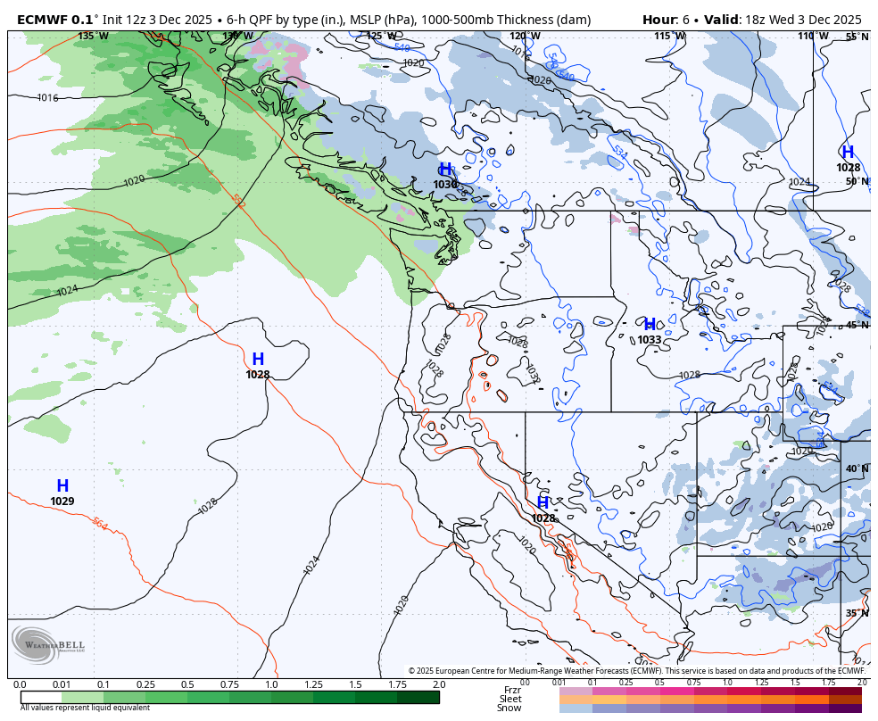
Monday is when an atmospheric river storm heads our way, followed by a second wave along the frontal boundary on Tuesday — and then perhaps a third soaking event on Wednesday.
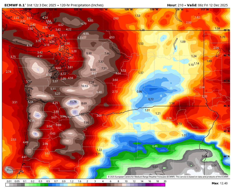
The folks who rate ARs on a 1-5 scale are preliminarily putting this storm at a Category 4, which while not rare, does speak to its rainfall potential.
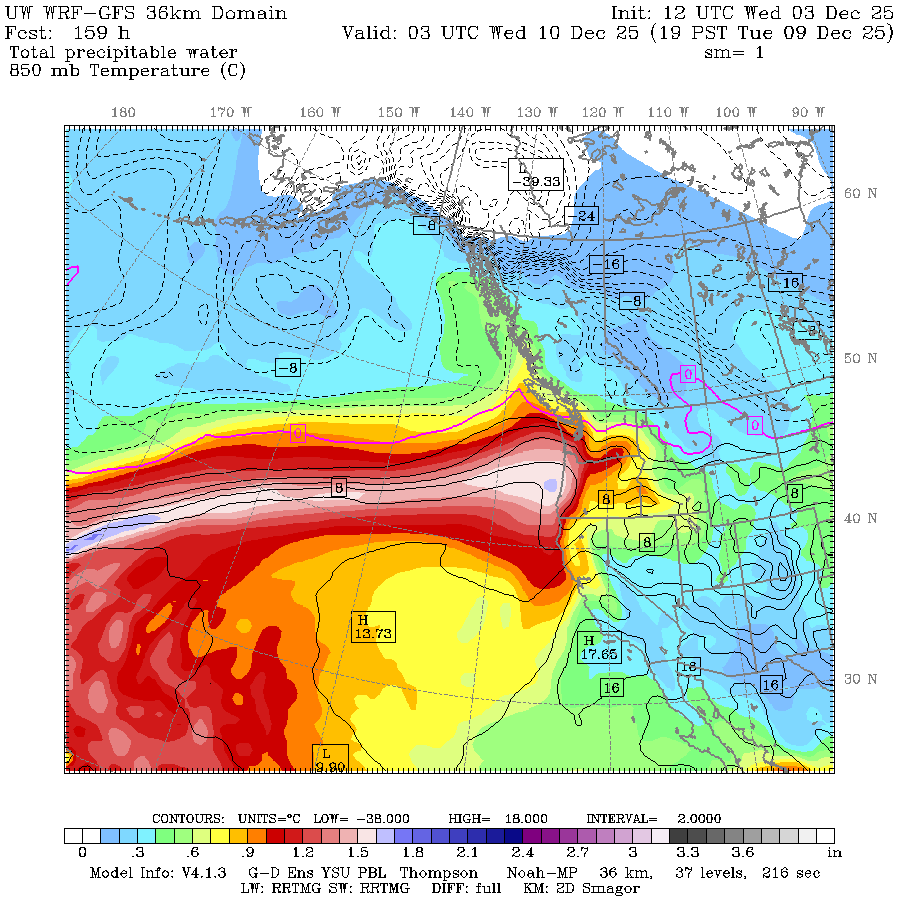
It’ll mean several inches of rain in the mountains where all that warm, moist tropical air slamming into the mountainsides gets squeezed out, and all that rainfall runoff heads for the rivers. And with relatively high snow levels, only limited amount of precipitation will remain stuck on the ground as snow.
We’re still several days out, so the forecast may still shift a bit as to who gets how much rain and when.
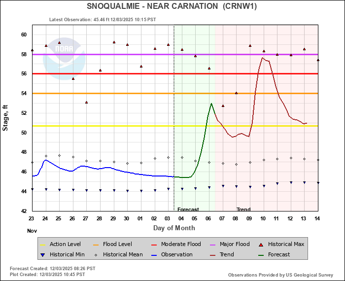
But initial model forecasts from NOAA’s Northwest River Forecast Center are now putting parts of the Snoqualmie and Snohomish Rivers at risk of moderate flooding in the middle of next week, with the Skagit and Tolt getting close to moderate stage.
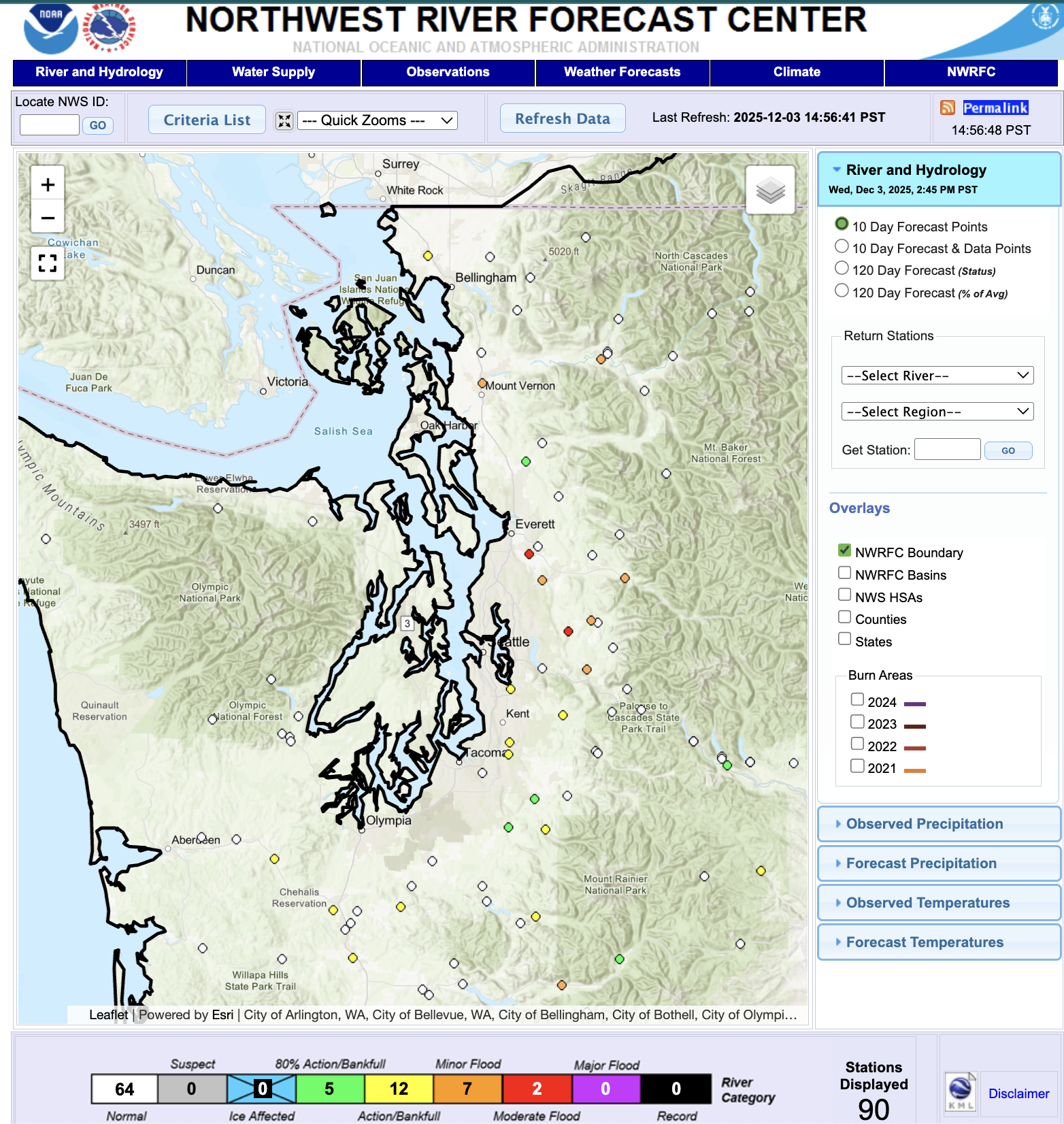
These forecasts too will likely fluctuate over the next few days but those in the river flood plains should bookmark that page, check it often, and be ready to start preparations.
(Quick aside: I know “atmospheric river” gets used a lot these days — including, admittedly, by me — but it is an accurate and literal term when the storms tap into tropical moisture in the Pacific. They can cary as much as 15-25 times the volume of the Mississippi River so they are noteworthy. Not all rain storms are atmospheric rivers, but many of our storms so far this autumn *have* been ARs — why it’s been wet, but we don’t have much snow to show for it… and why you’ve heard the term a lot.)
WHAT ABOUT IN THE LOWLANDS?
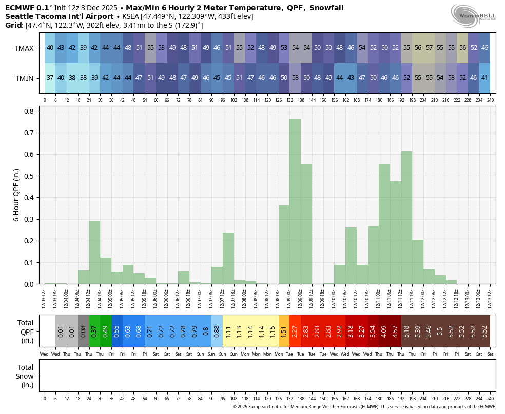
The ensemble models are still showing solid support for possibly 3-4 inches of total rainfall in Seattle and the lowlands from Sunday through Thursday, though the Olympic Rain Shadow will eat away at some of that at times between Downtown Seattle and the North Sound.
It’s been two years since Seattle had a day with 2+ inches of rain in a calendar day and that seems doable. 2+ inches in the city will lead to lots of ponding and localized flooding — plus don’t forget we’ll have the high astronomical tides and some lower pressure around that will present a threat of minor inland waters coastal flooding (like along the shores of Puget Sound and Salish Sea).
And it’ll be breezy-to-windy late Monday into Tuesday, especially in the Northwest Interior and may remain rather gusty through the mid week at times.
DO WE HAVE TO WORRY ABOUT “FLUFFY SENIOR” AND “JEFF” TOO?
It looks like once we get past the middle of next week the firehose backs off a bit. There are still some long range models that continue bouts of (lighter) rain later in the week. But some other models are putting the proverbial Lucy with the football out there teasing colder weather as we get into the middle of December.
That could elicit some cheers… or perhaps some other choice names that Lego would consider unfit for a family movie…
MORE TO EXPLORE:
- November ends up warm; Skiers give 2 thumbs down to early December outlook
- Why did Seattle’s snow forecast map look like this earlier this month?
- ‘I have to get the baby’: A Vancouver mother’s sacrifice during the Northwest’s deadliest tornado