Locally ‘catastrophic’ flooding possible along Skagit, Snohomish rivers as atmospheric river pummels Northwest
SR 906 washed out near Snoqualmie Pass (Washington State Patrol image)
UPDATE: City of Mount Vernon now asking everyone in 100 year flood plain of Skagit River to evacuate. More Info from City of Mt. Vernon including maps and evacuation routes
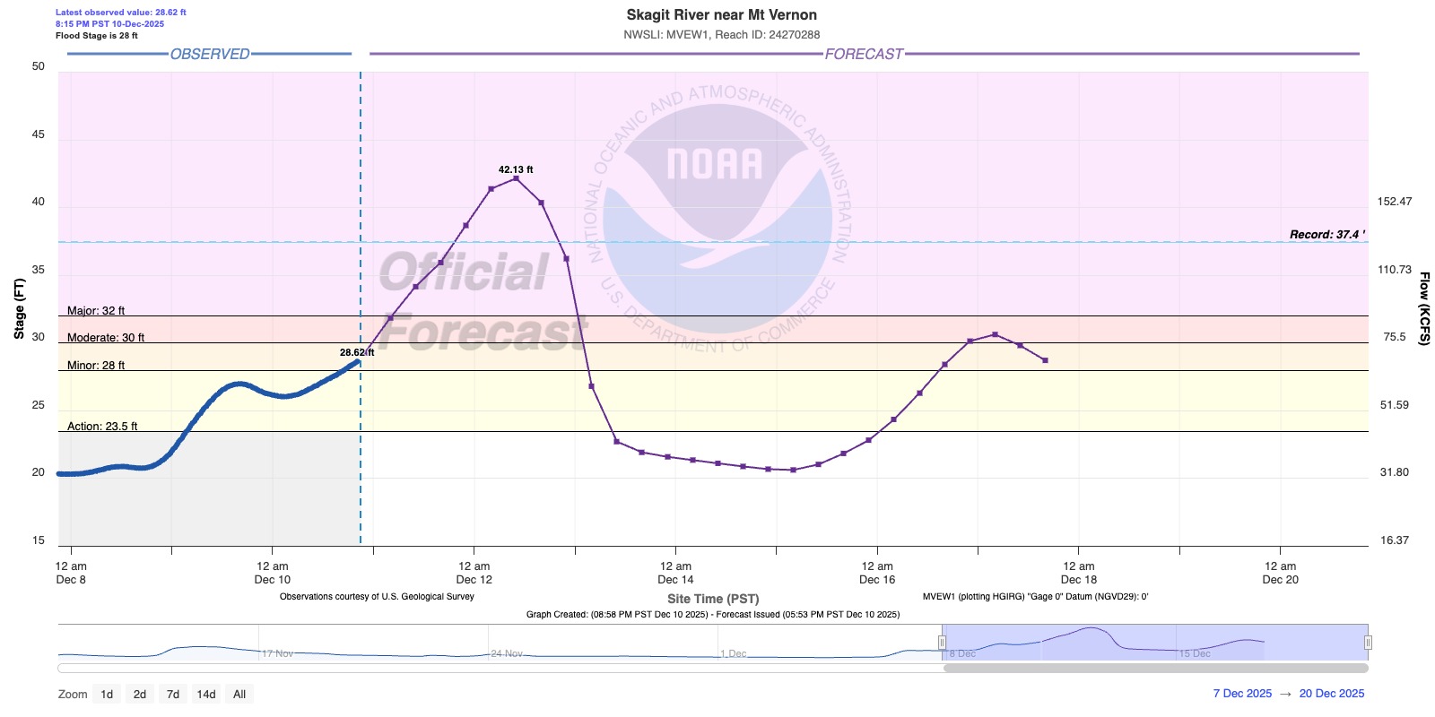
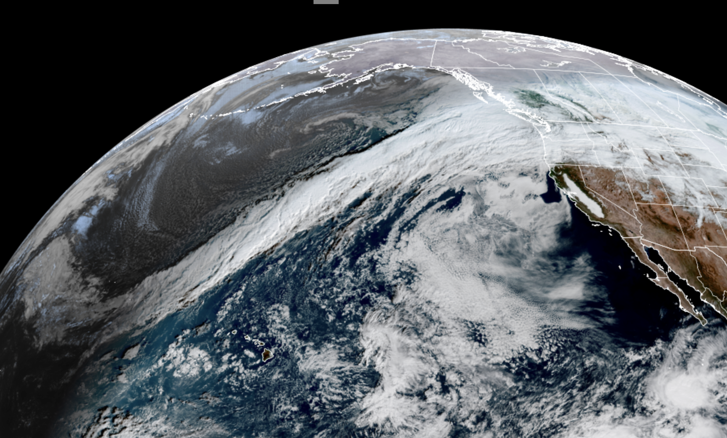
A dire situation is unfolding in Skagit County and other nearby rivers as relentless torrents of rain fueled by a multi-day atmospheric river storm has threatened to push multiple rivers to heights never before witnessed in recorded history.
Tens of thousands have been ordered to evacuate along the 100-year flood plain of the Skagit River, where forecasts show water heights reaching 4-5 feet over previous records, well over dikes and levees along the populated corridor, threatening unprecedented flooding along the likes of Mount Vernon, Concrete and Sedro-Woolley areas.
The National Weather Service has issued a Flash Flood Watch for the Skagit River basin This is DIFFERENT than the Flood Watches/Warnings already in place. Flash flooding is immediate, sudden flooding, usually triggered by convective rain events like thunderstorms but in this case it’s due to potential levee failures releasing sudden torrents of water.
While the Snohomish is still expected to reach just over its record flood from 1990.
“Locally catastrophic flooding impacts are possible along Skagit and Snohomish Rivers,” NOAA’s National Water Center said Wednesday morning. “Major and/or record flooding is expected, bringing an increasing threat to life and property. Overtopping of levees is possible.”

Skagit County has now issued a Level 3 evacuation alert for “anyone living within the 100-year flood plain.” The Level 2 urges residents there to be ready to evacuate within 24 hours. (A Level 3 would mean evacuate immediately.)
The Cedar River at Renton is also expected to come within fractions of a foot either way around its record crest, and up on the Olympic Peninsula, the Elwha River is forecast to hit a record crest Wednesday night at the McDonald Bridge.
There were 25 rivers on Flood Warning as of Wednesday, with 19 river gauges in major flood stage or forecast to get there, including along the Snoqualmie, Snohomish, Tolt, Cedar, Puyallup, Cowlitz and Carbon.
REALTIME FLOOD INFORMATION: RIVER FORECASTS & LEVELS // CURRENT FLOOD WARNINGS
Elsewhere “considerable flooding impacts are ongoing and expected to continue” into Friday, NOAA says.
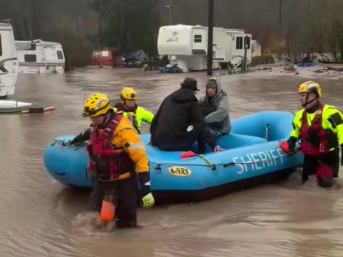
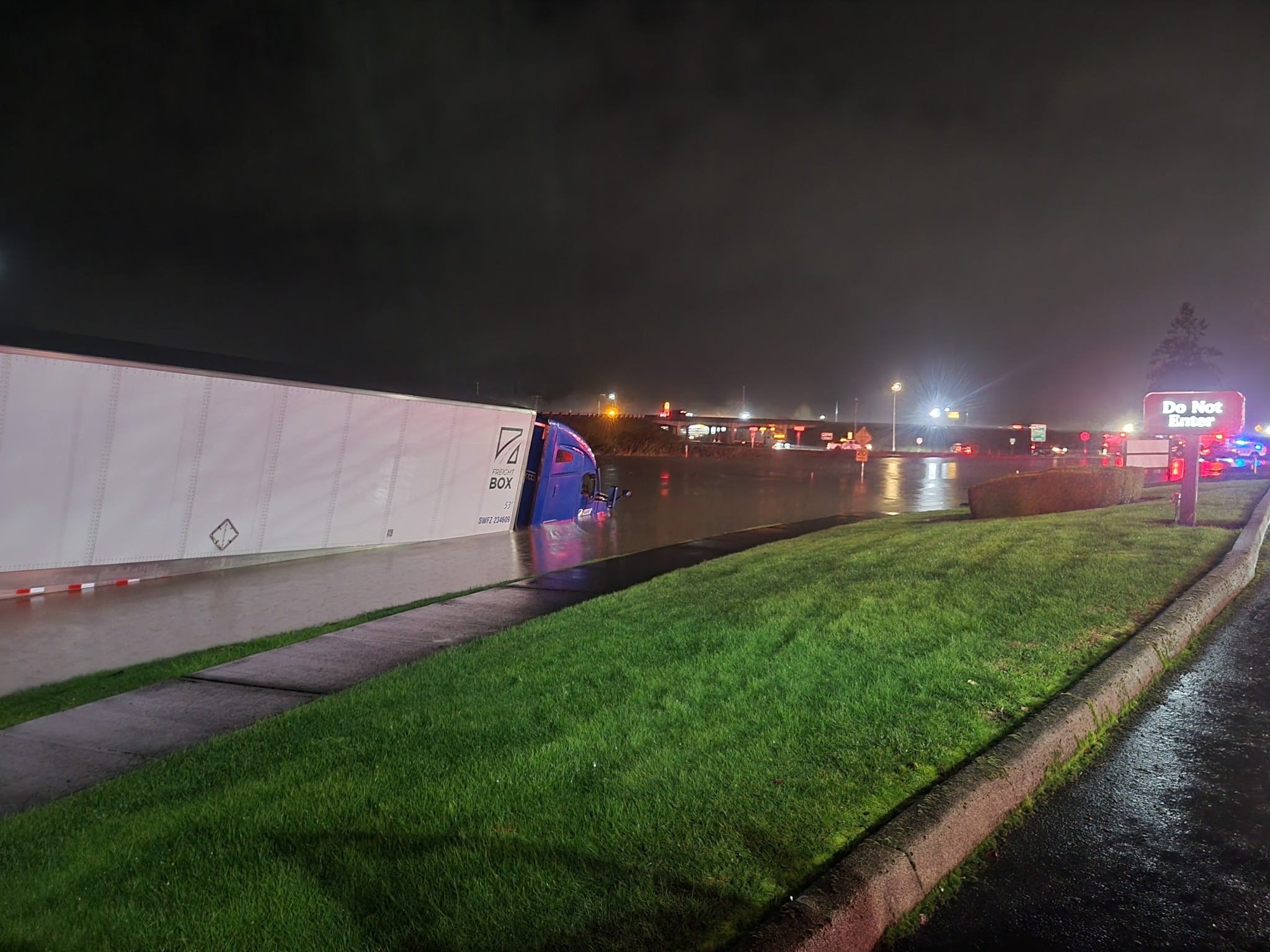
Water rescues have been reported up and down the Puget Sound area. Three people and a dog had to be rescued from their flooded home along the Middle Fork of the Snoqualmie River Wednesday, according to Eastside Fire & Rescue.

Another water rescue was under way at an RV park in Orting, where the Puyallup River left three people stranded and trapped in their RV, according to the Pierce County Sheriff’s Department.
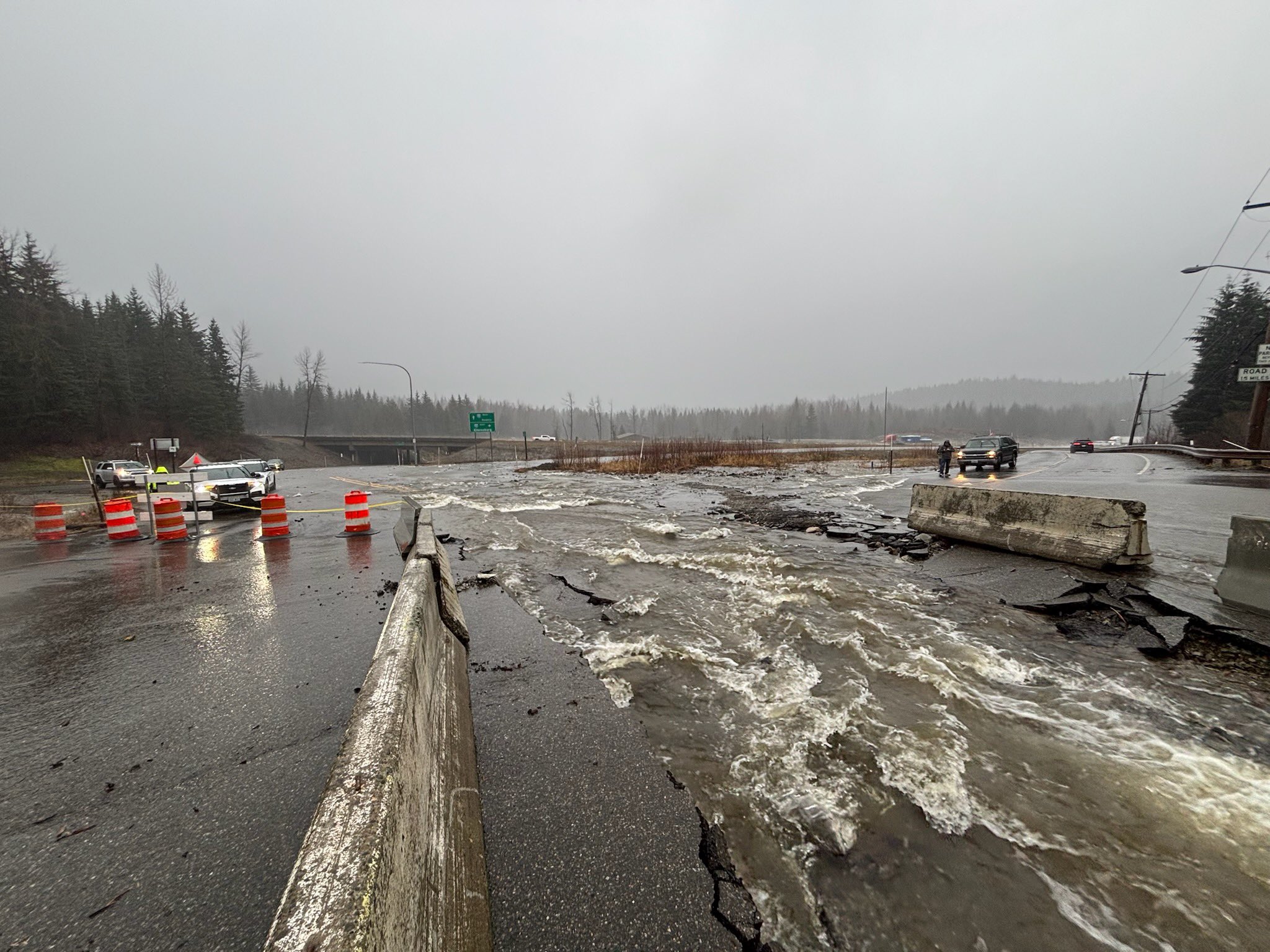
Water washed out a large section of SR-906 near I-90 at Snoqualmie Pass, according to the Washington State Patrol.
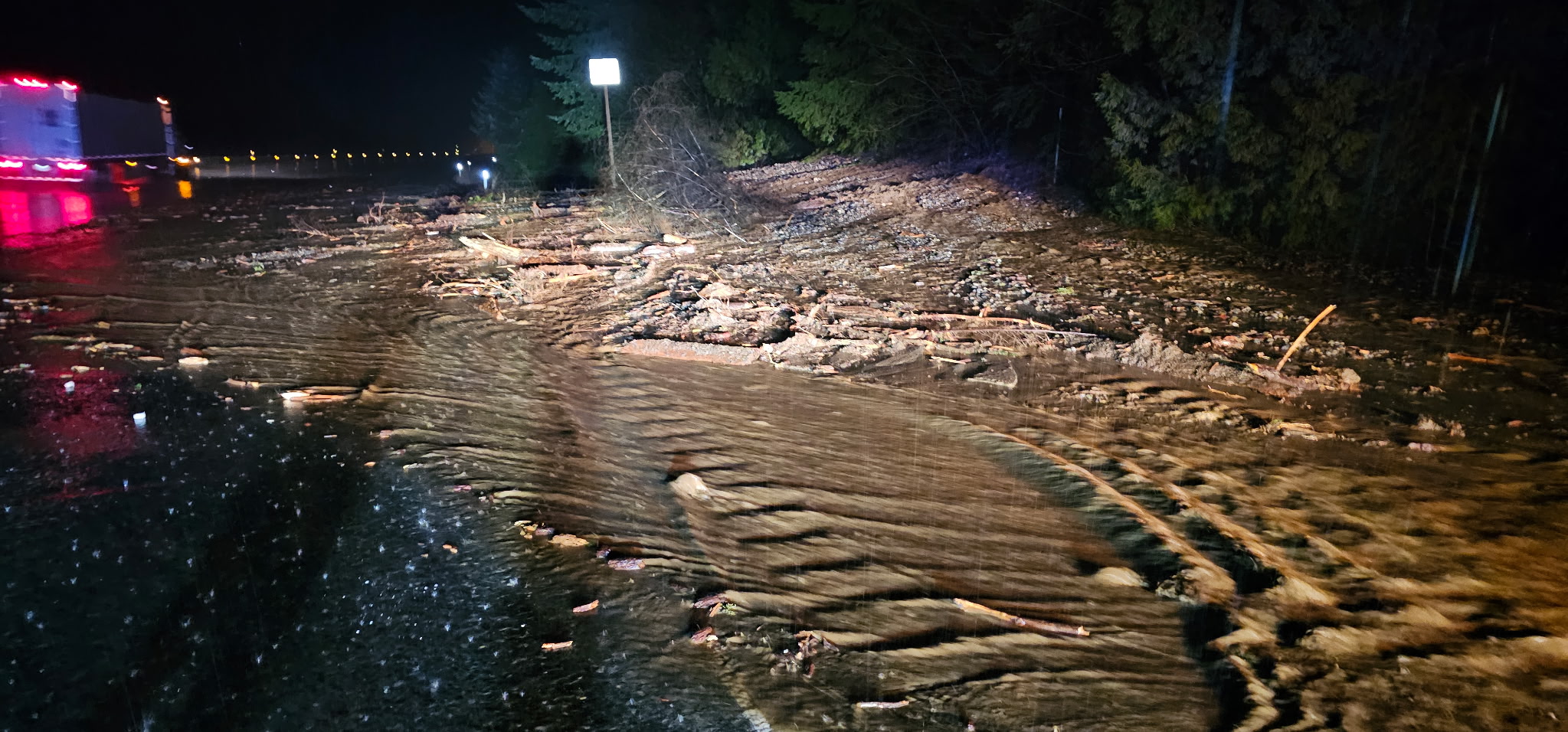
Mudslides are a growing risk as the grounds continue to become saturated. Already, a mudslide blocked the eastbound lanes of I-90 near North Bend early Tuesday morning, forcing a temporary closure.
Wednesday, US 2 was closed for 28 miles between Scenic and Coles Corner, west of Leavenworth, due to rocks, trees, and mud over the roadway in multiple locations, the WSDOT said.
RAINFALL FORECASTS INCREASE FOR SECOND ROUND OF ATMOSPHERIC RIVER
Weather-wise, the local meteorologists at NWS Seattle say forecast models have increased rainfall totals today with an additional 1 to 3 inches of rain across the lowlands and another 4 to 8 inches over the Olympics and Cascades through Thursday morning. “Locally higher amounts are possible over higher terrain of the western Washington Cascades,” NWS Seattle said, ”leading to even higher river forecasts and potential for more widespread major flooding to occur.”
Rain rates in the Cascades this morning near Snoqualmie Pass and Paradise reporting rates near or exceeding a half inch per hour, NWS Seattle said. “Paradise at Mt Rainier has picked up 3.25 inches of rain in just the past 10 hours” as of pre-dawn Wednesday morning.
The storm has tapped into tropical moisture thousands of miles away in central Pacific Ocean, with analysis showing part of the moisture source reaching as far west as the Philippines.
Not everyone it getting soaked yet — the Olympic Rain Shadow is back again for parts of the lowlands Wednesday morning shielding a small area around the Seattle/Puget Sound core from the heaviest rains this morning but the shadow will fade through the day.
Wind Advisories also remain in effect until 10 p.m. Wednesday across much of Western Washington lowlands including the Seattle/Puget Sound area for gusts to 40-45 mph — similar to winds on Monday with the storm’s first round.
EMERGENCY DECLARATION FOR SNOHOMISH COUNTY
Gov. Bob Ferguson has moved the state emergency operations center to a Level 1 activation — the highest level of activation.
Snohomish County has declared a state of emergency allowing streamlined government disaster response.
In Grays Harbor County, Lake Sylvia State Park was closed Tuesday while crews respond to impacts brought on by this week’s heavy rain. The current atmospheric river weather event has raised lake levels and placed added stress on the 100-year-old Lake Sylvia dam. County officials say elevated water levels and continued rainfall are creating concerns about the pressure placed on the century-old dam. Crews are continuously monitoring the dam and at this time there are no visual structural changes. Water levels have receded by approximately one foot since Monday evening.
In Lewis County, Exit 72 in Napavine was closed late Monday into Tuesday due to flooded roads that required 5 drivers to be rescued, according to Lewis County Fire Protection #5 officials. None were injured. Multiple other water rescues were made along the Skykomish River, according to Snohomish Regional Fire & Rescue.
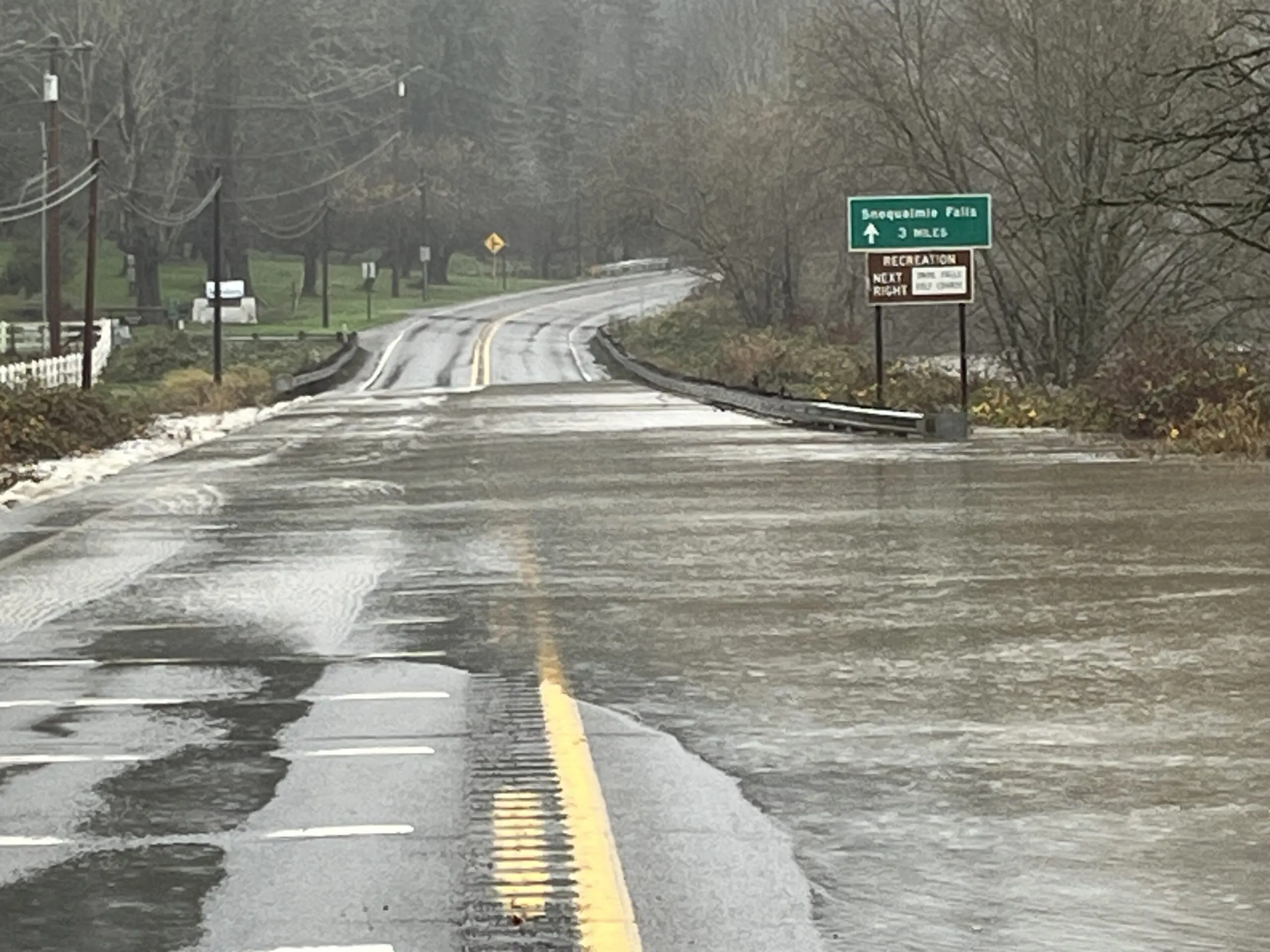
SNOQUALMIE RIVER REACHES HIGHEST LEVEL IN A DECADE
Down on the Snoqualmie River, drone video from Benjamin Jurkovich with Washington Weather Chasers showed farm lands were already flooded in Fall City as the river reached Stage 4 flood alert on the King County System.

Over at Snoqualmie Falls, the river reached heights not seen in 10 years.
SR 202/Redmond-Fall City Road SE was closed Wednesday between Fall City Rd and Fish Hatchery Rd for water over the roadway.
Rainfall totals with the first storm varied widely across Western Washington, an ode to the vast terrain difference and ensuing microclimates. Some of the higher mountains in the Olympics and Cascades registered 7-8 inches of rain through early Tuesday.
In the lowlands, Southwestern Washington got the brunt of the rain with nearly 4 inches in Chehalis and Olympia. Rainfall totals averaged about 1.5-3.0 inches in the Seattle–Tacoma area, while a robust Olympic Rain Shadow shielded the heavy rains for hours in the North Sound, leaving places like Everett and Marysville with barely a half inch of rain.
The heavy rains will taper off Thursday morning and we could get at least a relative lull in the rains with just lighter scattered showers Friday and Saturday. However, the long range forecast remains daunting with steadier rains Sunday and potential for additional heavy rain events next week, slowing the floodwater’s drop and perhaps renewing flooding threats.
MORE TO EXPLORE:
- ‘Hurricane Hunter’ requested to fly mission into strong atmospheric river event this week
- Sequim’s ‘blue hole’; and how the Olympic Rain Shadow literally shines on the city