
ENSO Forecast
Skiers and snowboarders are just about getting close to official Emerald City Weather Blog Emergency Kittens status…
Recent snowstorm aside that brought a few feet of fresh powder to the Cascades this week, snowpacks remain well below average, another warm storm looms this weekend to wash some of the snow away, and long range forecasts show an extended dry period coming soon…
And now, El Niño is making unwanted appearances in headlines.
NOAA has posted their monthly update on the status of the El Niño/La Niña oscillation and we are *still* in a weak La Niña pattern. But their latest data continues to suggest La Nina will just barely survive the winter, and next winter may be a not-so-polar opposite. (Though it’s not like La Niña is about to win any winter awards so far…)
A quick recap: La Niña and El Niño are part of a 3-7 year ocean cycle that formally goes by the name El Niño Southern Oscillation, or ENSO. It’s based of measurements of water temperatures in the central Pacific Ocean, whose changes have been found to influence global weather pattern.
Researchers have learned that when those sea surface temperatures (“SSTs”) in a certain part of the tropical Pacific cool to more than below 0.5 degrees C below average (0.9 degrees F), we get conditions consistent with what we call “La Niña”. If it’s warmer than average, it’s an El Niño, and near average it’s formally called “neutral” conditions and informally called “La Nada”.
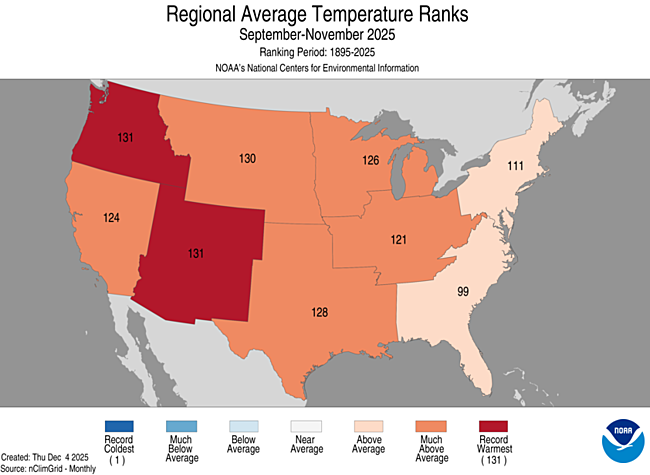
Most La Niña winters end up cooler and wetter than average. We’ve got the “wetter” part right so far, but “cooler”? The Pacific Northwest just had its warmest Meteorological Autumn (Sept. 1-Nov. 30) on record and Seattle’s December was its 8th warmest. Meh.
But El Niño winters are usually the opposite.
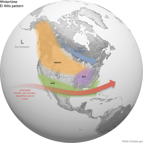
The jet stream typically dips south, pushing our storm into California and the Desert Southwest and leaving us high and dry — or at least warmer and drier than average. Most of lame ski and mountain snow seasons come in El Niño winters, and lowland snow events are rare— even more so than the “usual” rare.
So it’s not exactly welcome news that NOAA has significantly bumped up the odds of El Niño returning later this year, becoming the favorite by mid summer and a 61% probability of being here by late summer, which would have it entrenched by the winter.
The natural progression of ENSO would portend we’re due for El Niño, so this news isn’t surprising. But there are three lifelines though for skiers to cling to:
The Spring Barrier: Mid winter into early spring is when the long range models that try to forecast El Niño are at their lowest skill. It’s the time of year when ENSO effects on the weather patterns fade and with less data to go on, the models are prone to larger errors.
Moderate Status: If we somehow get to moderate El Niño status, surprisingly many of those winters turned out OK.
No Slam Dunk: As I mentioned earlier, it’s not like the La Niña forecasts for skier optimism THIS year have exactly panned out. So it’s not a slam dunk even if we do get El Niño.
Oh who am I kidding? Skiers deserve this:
Very cute kittens! You can never go wrong with kittens!
As for El Nino, if we’re due for it, then we’re due for it. I just hope we get enough snow to meet the region’s water supply needs when it arrives.