La Niña has returned! Here’s the good news it typically means for the Northwest ski season

Photo courtesy: Tim Clifton Photography
NOAA made it official Thursday: La Niña is here.
Skiers and snowboarders probably didn’t even need to hear official word. They likely knew it was coming since it had a 71% chance of coming as of last month, but they still probably knew the moment it happened when whatever the winter sport equivalent of their “Spidey-sense” went off.
But does that mean it is time for me to break out Emergency Kittens for the sun fans this winter? (Trick question — it’s probably always time to break out Emergency Kittens for sun fans in our winters…)
In general though, La Niña is more a winter weather fan’s friend than someone eager to cancel winter. (That would be an El Niño…)
SO WHAT IS THIS LA NINA I ALWAYS HEAR ABOUT, AND WHY DO WE CARE?
La Niña is part of a 3-7 year ocean cycle that formally goes by the name El Niño Southern Oscillation, or ENSO. It’s based of measurements of water temperatures in the central Pacific Ocean, whose changes have been found to influence global weather pattern.
Researchers have learned that when those sea surface temperatures (“SSTs”, if you’ve ever seen that before) in a certain part of the tropical Pacific cool to more than below 0.5 degrees C below average, we get conditions consistent with what we call “La Niña”.
When it’s the opposite and warms more than 0.5 degrees C above average, that’s known as El Niño. When it’s within a half degree of average, it’s “neutral” conditions, or what some informally call “La Nada.”
In the La Niña phase, two important things typically frequently happen for the Pacific Northwest: The Polar Jet Stream arcs high to the north into Alaska and the Yukon, then dives south into the northern tier of the U.S. pulling cool air down along with it. In addition, the Pacific Jet Stream generally sets up shop aiming right off the ocean and into the heart of the Northwest, steering all the storms our way.
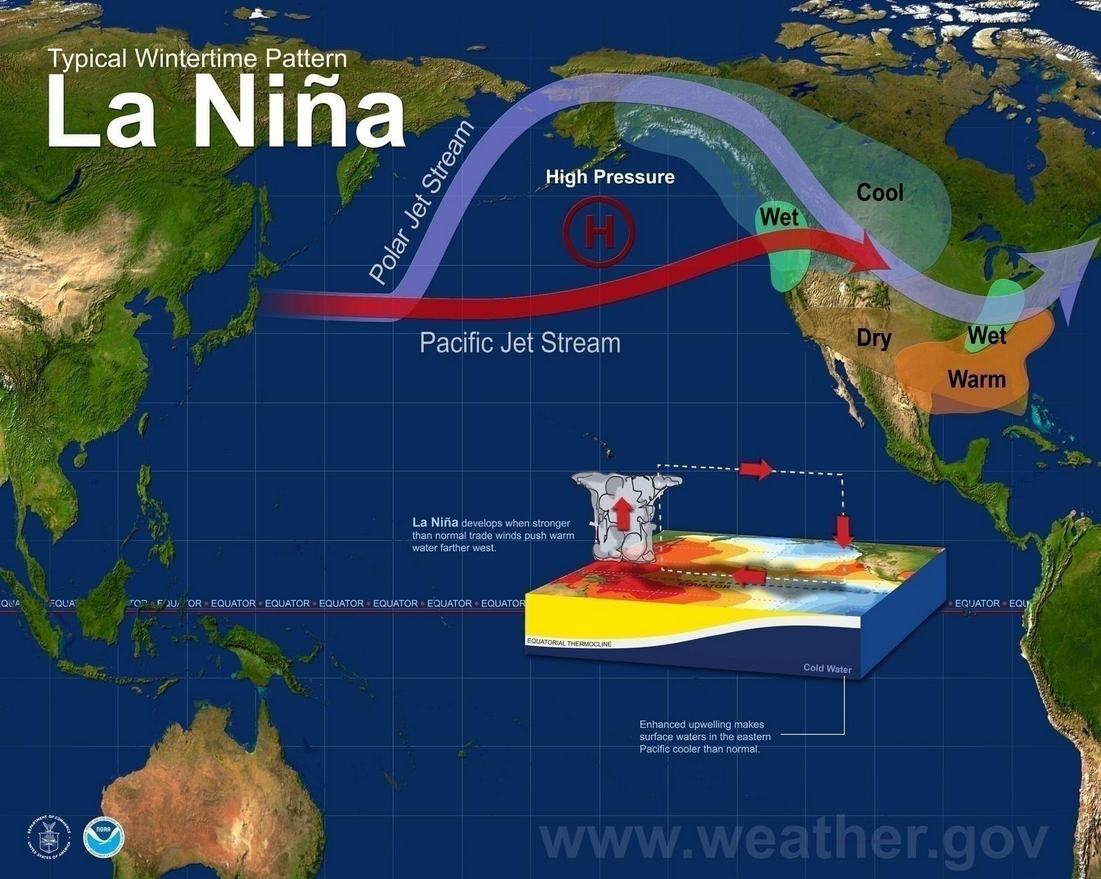
That combo makes for an autumn and winter that in most instances leads to above average precipitation and below average temperatures. So as you might surmise then, La Niña winters tend to be good for our mountain snowpack/ski season, increase the odds a bit for lowland snow events, and on the other hand, not so good for those looking to not have it rain 5 days out of every 7.
But it’s not a slam dunk.
SUN FAN OVER HERE: TELL ME THERE’S AN ASTERISK I MISSED SOMEWHERE?
Hmmm… Not yet, but OK, I’m feeling generous: How about three?***
* Not all La Niña autumns and winters lead to cooler and wetter winters. There have been instances where other factors overrode the predominant La Niña pattern to tilt the season another way. 1984-85 and 2000-01 winters were moderate La Ninas that ended up much below average for rain and snow.
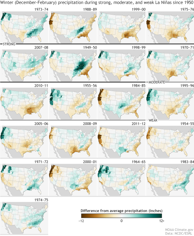
* Last winter was a weak La Niña and as you saw the snow season, while not terrible, underperformed a bit.
* In that regard, this La Niña is also expected to be weak and short lived, with what NOAA says is a 55% chance of returning to neutral conditions by mid winter.
So La Nina’s influence may not last the entire fall and winter season.
CAN YOU SUM IT UP FOR THE TL; DR CROWD?
La Niña will weigh the dice in our favor for a healthier mountain snowpack and good ski season, and also likely mean the lowlands will see above average number of days with precipitation and maybe even a few more lowland snow days. But it’s not a guarantee, as some La Niña winters have failed to live up to those expectations.