Still a tricky travel forecast for Thanksgiving weekend around Western Washington
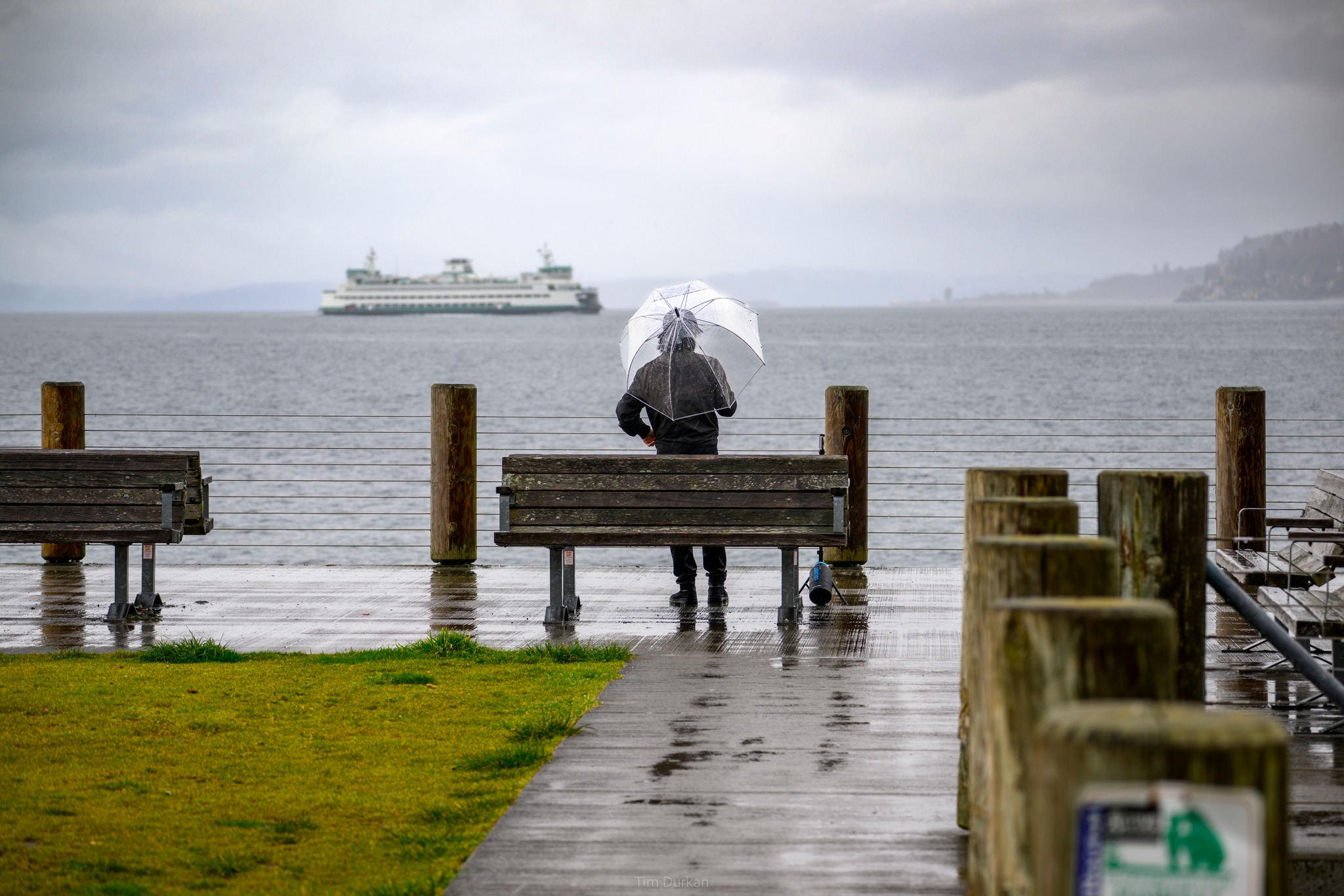
Photo: Tim Durkan
(TL; DR: If you’re not going over the passes, weather shouldn’t be factor for Thanksgiving. If going over passes, expect some snow at times, especially later Tuesday and early Wednesday. Read on for specifics.)
Some Thanksgiving you hear stories of when families get together it can lead to, shall we say, spirited discussions that the dinner table.
This year, someone better sit the European and American GFS forecast models at different ends of the room. They’re already bickering.
The result is a bit of a headache for forecasters as we try to get a grasp on the big holiday weekend with wide-ranging opinions from our models on what the Seattle-area weather will do.
The good news is, they’re fighting over semantics and nothing of like potential for a major impactful storm, though some forecasts show a few periods where the weather can be a bit ornery.
The main hazards for the weekend will be for mountain pass travel. If you’re not going over the mountains or planning to set your dinner table along the banks of the Skokomish River, your Thanksgiving weekend will likely not be impacted by the weather, unless you’re hoping for the big family football match without traipsing mud into the home.
TUESDAY: SNOW IN THE PASSES STARTS IN THE AFTERNOON
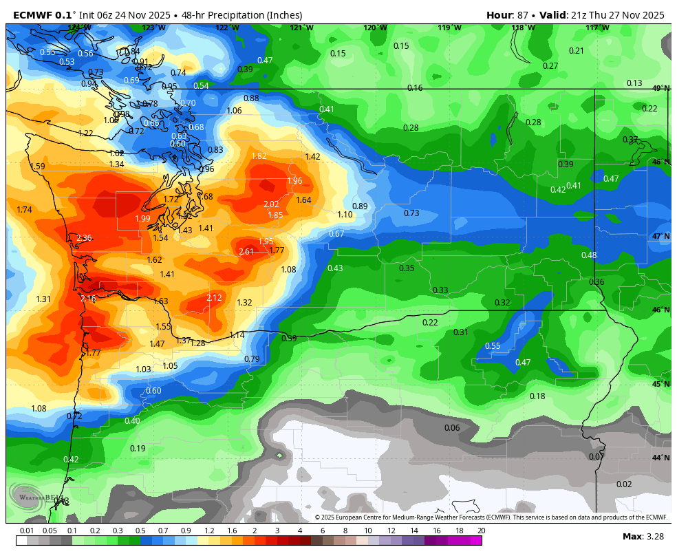
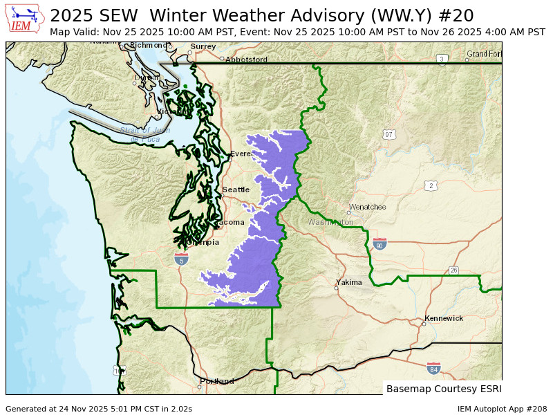
The weather will remain tranquil through about Tuesday afternoon when the first frontal system arrives, spreading rain from south to north in the lowlands, and snow to the mountain passes. It’s not looking like gobs and gobs of snow but 6-10 inches are now possible in at Stevens and Snoqualmie. A Winter Weather Advisory is now in effect from 10 a.m. Tuesday through 4 a.m. Wednesday.
So if you have a full aversion to driving in pass snow, avoid Tuesday afternoon, evening, night and into Wednesday morning. If you are an experienced snow driver, then it’s probably not enough to cause issues.
WEDNESDAY: A HODGE PODGE OF WEATHER
The rest of Wednesday is a bit of a wild card — and I realize it’s one of the most high-interest travel days. A warm front will be pushing through, keeping the rain at times in the lowlands (there may be a few hours’ break in there but the models are bickering about when and how much) but the next storm approaching will draw in some easterly winds.
MORE TO EXPLORE:
- Holiday chaos: Looking back 40 years on Seattle’s epic Thanksgiving snowstorm and arctic blast
- ‘Cirrius’ly cool clouds spotted north of Seattle
- Dramatic sunset and shadows makes it appear skies are almost erupting
The east winds don’t look too impactful as far as the winds themselves, but they can create localized cooling along the passes that even through snow levels are high in general, cold air funneling through the passes could keep snow, a mix, or even freezing rain there.
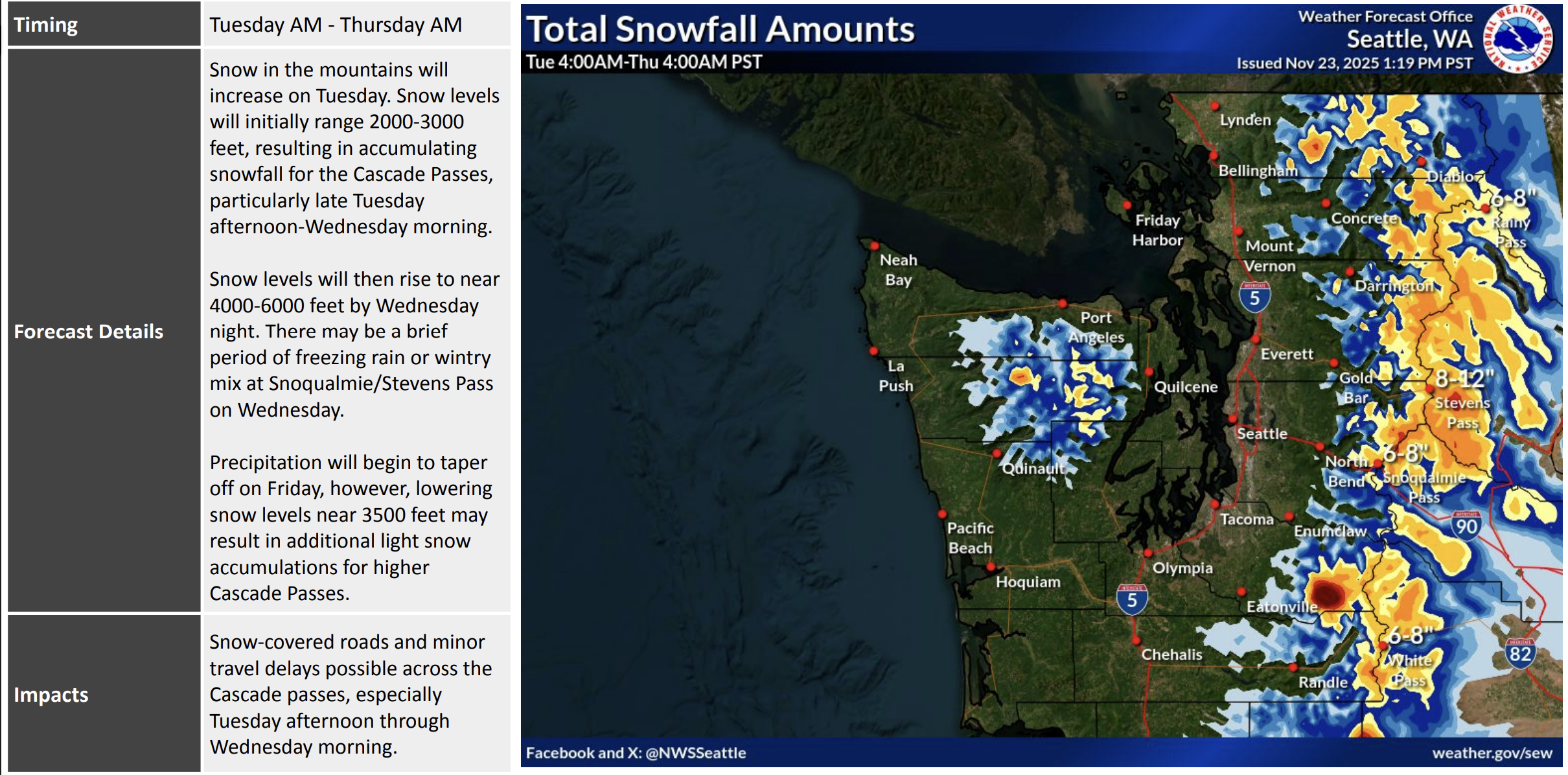
There’s still quite a bit of uncertainty over how the passes will shake out so best advice is to stay tuned. We could luck out that with snow levels generally rising the passes turn out mostly wet but the east wind is a chilling monkey wrench.
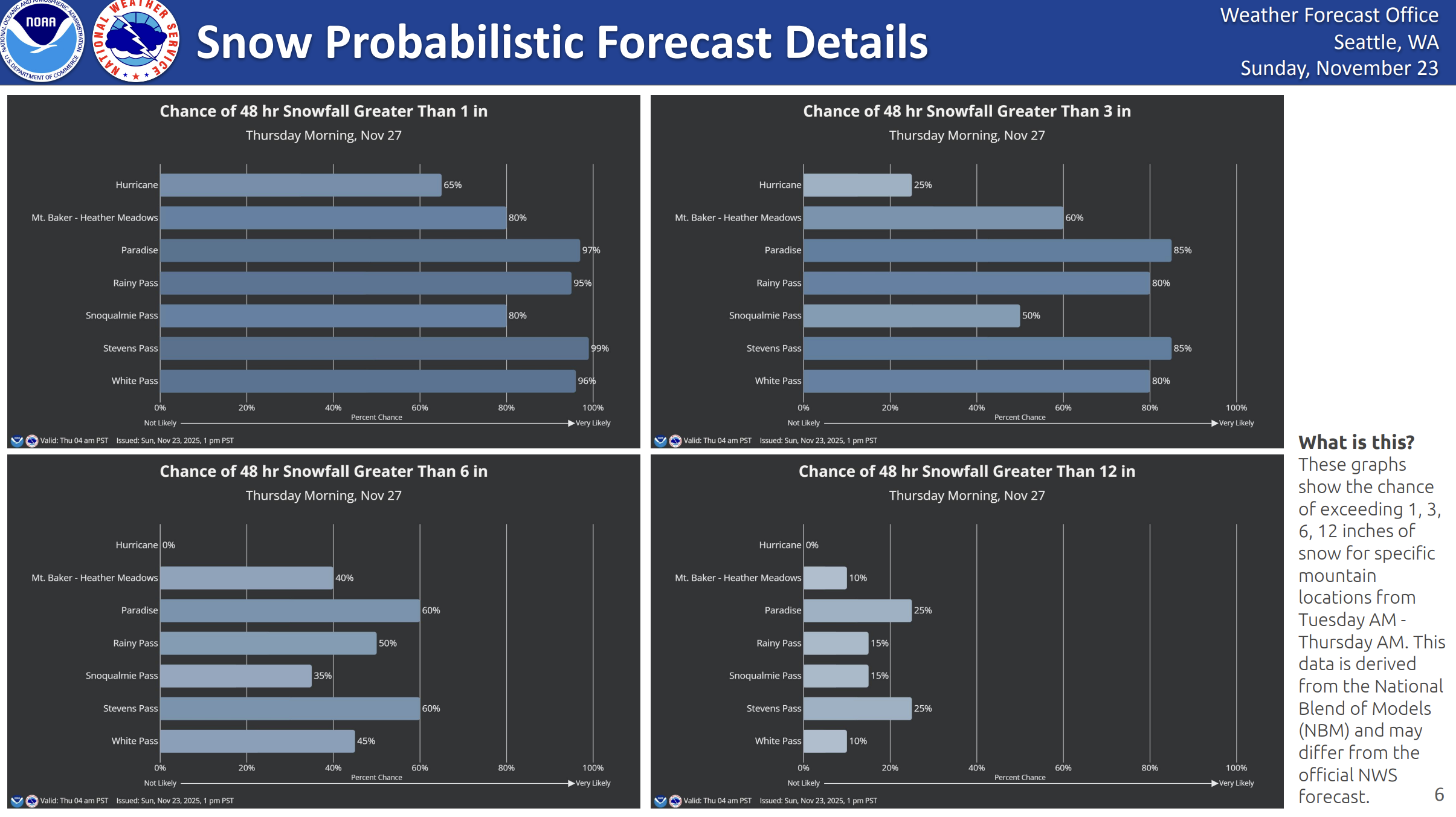
This chart shows the odds of snow accumulations at each Cascade pass in 48 hr period from Tuesday-Thursday a.m. Snoqualmie is just 50/50 at 3” or more but Stevens Pass is 85%.
THANKSGIVING DAY: WET AND BLUSTERY
Ding dong. Who’s at the door now? Oh look, another storm system is looking for a spot at the table.
The Euro and GFS models are surprisingly in some agreement that another low pressure center will move into the region on Thanksgiving day, though they still bicker on its track.
But the good news is even with the track uncertainty, the storm doesn’t look too strong. Thus, no matter where it goes, wind speeds are still looking like they’ll stay under impactful speeds though so turkey cooking should remain a go. We’ll keep an eye on this too though in case the wind speeds end up stronger.
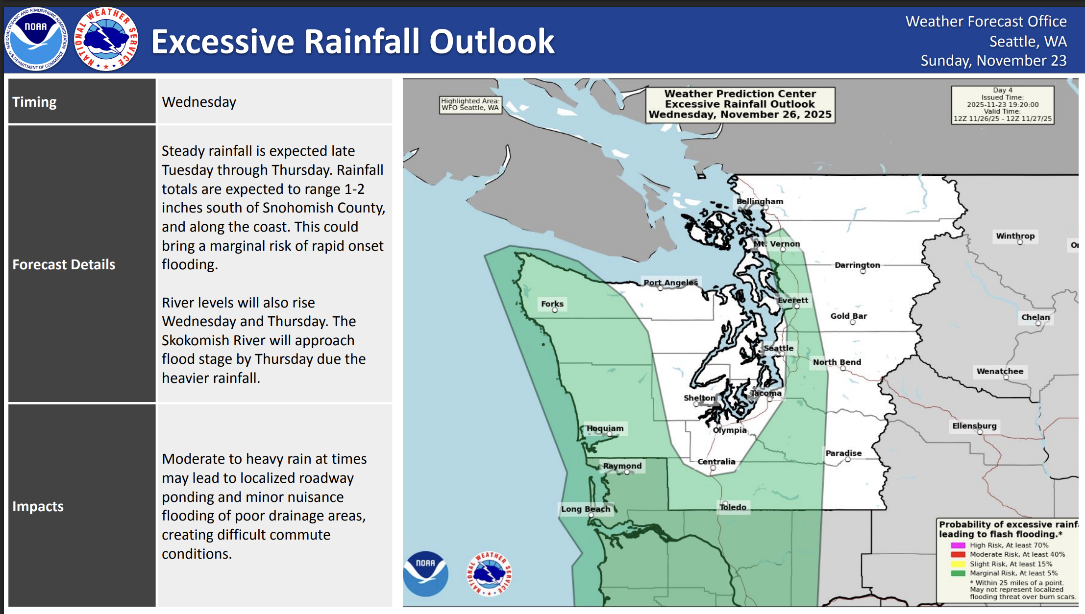
As for rain, NOAA’s Weather Prediction Center still has a level 1 out of 4 risk of excessive rain Wednesday into early Thursday that includes parts of the Puget Sound area which means watch for ponding or localized flooding from heavy rains.
DO WE THEN FINALLY COOL OFF, OR WHAT?
The forecast models resume their bickering for the rest of the weekend. The Euro goes dry and cooler; the American GFS keeps it kinda wet through Friday into early Saturday. What about the big cool down that’s been teasing out there in the extended? Still teasing.
All the forecast models have been struggling with when and where arctic air will set up in Canada. The American model is more aggressive even pulling in some colder air toward the back half of the weekend and is chilly much of next week. The Euro is more subdued, pushing the cold air farther east and leaving us under influence of the milder Pacific. It does eventually have colder air here but much later next week. So far it’s just “cooler” air and not “OMG here comes the snow” cold.
But at least later Saturday into Sunday is looking pretty good so far for return travel. Mother Nature will likely be glad by then to get the GFS and Euro back on the road and restore some peace and quiet 🙂