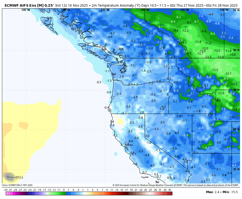
Temperature anomaly map for Thanksgiving Day
For being in the heart of November, the weather around here is going to take what will qualify as a break. Not like a week of sunshine, mind you, but just not very stormy.
But if you’ve got popcorn ready to pop and are looking for some exciting weather to chase, maybe keep an eye on Thanksgiving weekend which isn’t really up to 😮 Emoji status yet, but would qualify as 🧐 or…something else.
WEATHER EMOJI STATUS FOR SUNDAY AND MONDAY: 😶
We have a weak system sliding through the shroud of fog that will bring the return of light rain at times Sunday afternoon into the night. And then getting into the early Thanksgiving spirit, there’s enough leftover rain showers to pepper the region into Monday.
WEATHER EMOJI STATUS FOR TUESDAY AND WEDNESDAY: 🥱
A brief ridge of high(ish) pressure slides through on Tuesday into Wednesday which looks to keep us dry, although that could lead to some continued foggy nights and mornings. Wednesday will feature more non-foggy clouds as approaching system splits apart offshore, picking more on California and B.C. and leaving us without much leftover.
It could be a little breezy in the Cascade foothills with some east winds feeding that shredding storm offshore, but not impactful speeds at this time.
(A dry Wednesday would not be unusual, but a dry November 19 would be HIGHLY unusual as it is statistically the wettest day of the year.)
THURSDAY AND FRIDAY EMOJI STATUS: 😛
Weak weather systems return for the end of the week with just some light rain at times and minimal accumulations.
NEXT WEEKEND EMOJI STATUS: 🥰 or 🫤 or 🙄 depending on your level of being a rain fan.
The weather systems look a little wetter over next weekend but still nothing unusual, just clearing a low bar set by the weaker systems of the days prior.
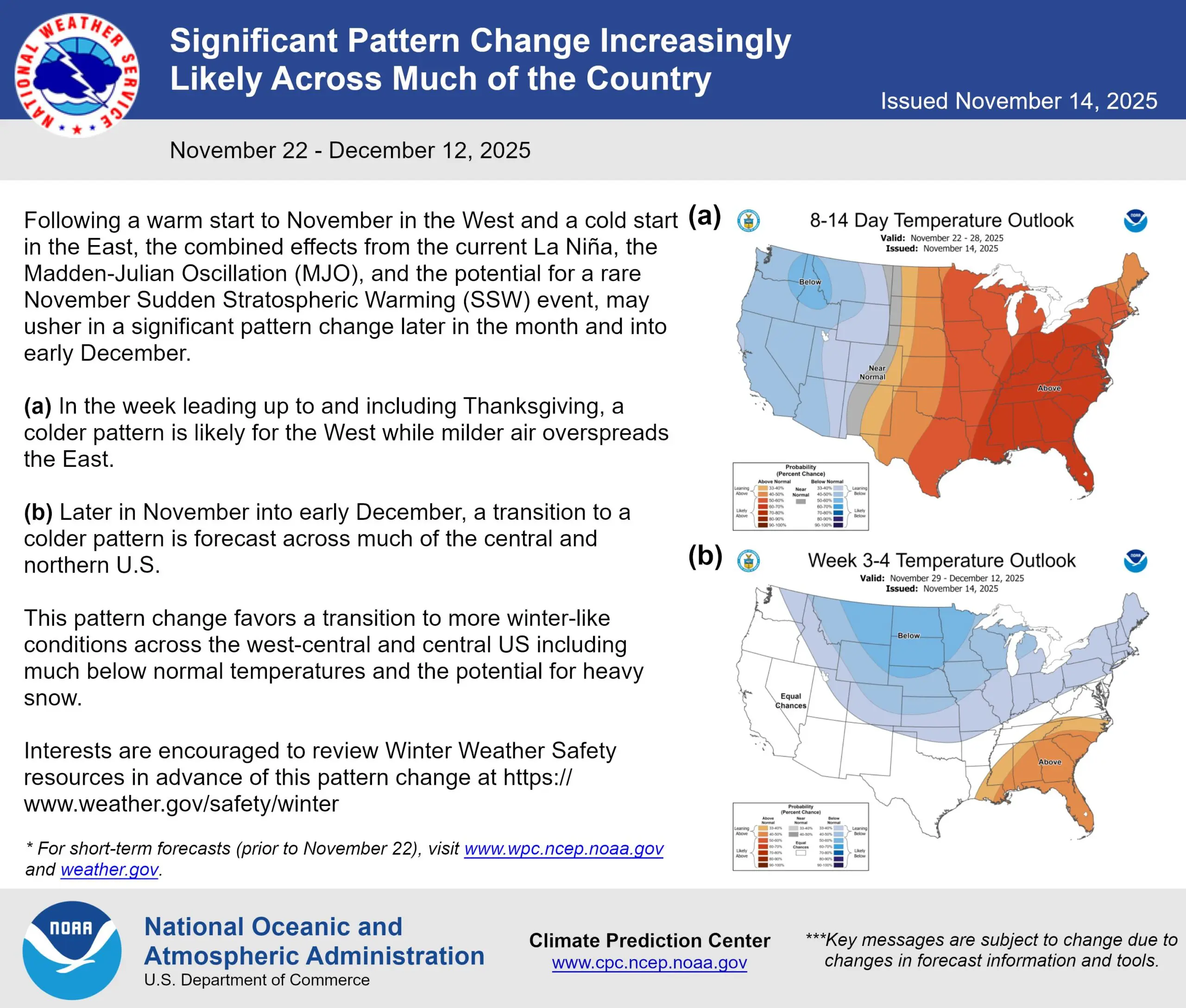
THANKSGIVING WEEK EMOJI STATUS: 🤨
There is a lot of chatter about a change to a cooler weather pattern coming mid to late next week as Thanksgiving Weekend approaches and arrives. (See earlier posts here in my Facebook feed or my blog for more into on why).
This is still at least it the early stages looking more exciting east of the Rockies (boo!) than the Pacific Northwest, but we could still get in on some of the chill.
Right now, I’d say the best odds of what would happen is we’ll cool off Thanksgiving week and it’ll be the coldest stretch of weather for the young season, but more like mid 40s for highs and low-mid 30s for lows — essentially taking about normal Christmas Day weather and moving it in for Thanksgiving.
If so, the only potential impacts so far would be to start piling up some snow in the mountains and passes but that’s of course not unusual for Thanksgiving week and it’s too early to know yet if it’ll be wet vs. dry for that weekend.
The end of the long range — essentially the end of Thanksgiving weekend into like first couple days of December — are hinting at even colder air starting to pool in BC but that’s like a movie cliff hanger of where does it go from there? That NWS post from Friday would indicate it’s more likely to go east 😛
Of course, it’s early and a lot can change. But while it may not end up being super noteworthy, it is looking good at least that we can ditch this mild start to autumn. The Nov. 1-15 period was the 8th warmest in Seattle and warmest since 2016.
And if it goes from 🤨 to 😱 status, we’ll of course let you know!