Winds start to clear smoke from Seattle, but trigger new fire warnings for Eastern Washington
 Scott Sistek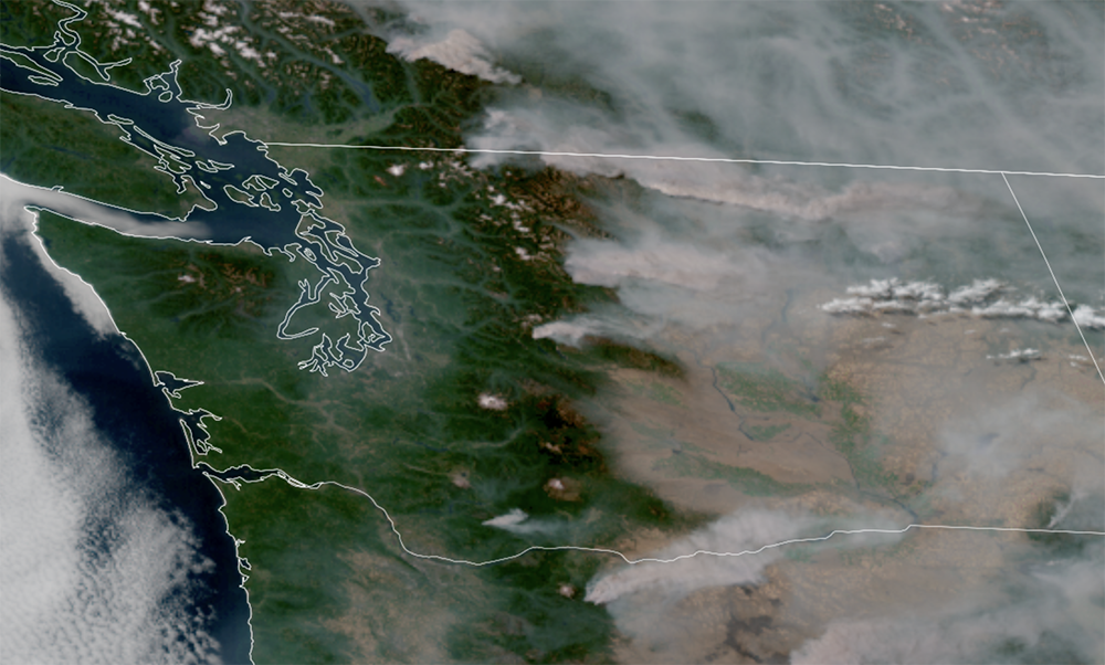
GOES-18 satellite image of the heavy smoke across Eastern Washington and lighter smoke on the west side on Aug. 6, 2026. (NOAA / CIRA / RAAM-B)
The wildfire smoke is on its last hours of hanging around in Western Washington Thursday. But unfortunately, the price to clear the smoke for the west side is increasing the risk that even more fires could start in Central and Eastern Washington to put even more smoke into the region.
Let’s cover both events.
FIRST THE GOOD: SMOKE SHOULD SLOWLY BUT STEADILY IMPROVE THE REST OF THURSDAY IN THE WEST
By Thursday afternoon the air quality readings were…slightly better than the morning. There were lots of yellow (moderate) and orange (unhealthy for sensitive groups) dots around Seattle and the I-5 corridor, with better air quality along the Puget Sound waterfront and worse inland around and past I-405 — though it’s more orange dots than red (unhealthy) dots now, so… yay?
MORE: Current Air Quality Map for Western Washington
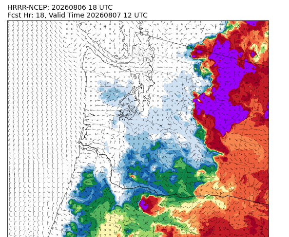
But the smoke models are consistent that the ocean winds will come in this evening and tonight and finally push the smoke off to the east. The satellite image already shows a little blob of fog coming down the Strait of Juan de Fuca Thursday evening, and the smoke plumes in Central Washington are already leaning toward the east.
MORE: Here is how to find and read wildfire smoke forecast models for Seattle and the U.S.
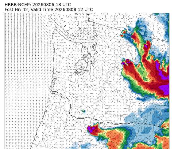
More importantly, the smoke model maps look mostly clean from any haze by Friday morning in Western Washington, and totally blank by Friday evening.
The official forecast has Seattle “in the green” by Friday evening and Bellevue/Issaquah in the green by Friday night.
MORE: Interagency Wildland Fire Air Quality Response Program
NOW THE BAD: THOSE WINDS WILL ONCE AGAIN RAISE THE FIRE DANGER IN EASTERN WASHINGTON
Similar to last Saturday, these west winds will push across Central and Eastern Washington, starting late Friday, and lasting into this Saturday. They will do a good job of scouring out all the smoke currently piled up against the eastern slopes of the Cascades where air quality readings have ranged from 300 to seemingly eleventybillion.
Normally, these winds would also bring welcome relief from the heat. But not now as these gusts will combine with very low humidity and, of course, an ultra-parched land to reintroduce elevated fire dangers.
A Red Flag Warning — essentially a “Fire Weather Warning” — is now in effect for a large swath of Eastern Washington, including all of the Spokane area, the Columbia Basin/Moses Lake, Palouse/Pullman, and including northern Central Washington like Wenatchee, Chelan, and Winthrop. (Yakima and the Tri-Cities are not in the warning.)
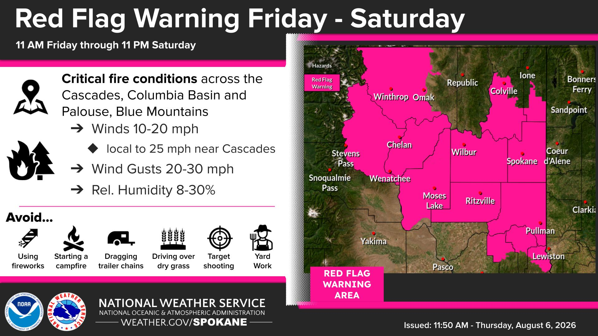
Here, we’re expecting the dangerous combination of wind gusts of 20-30 mph with relative humidity levels of 8-30%.
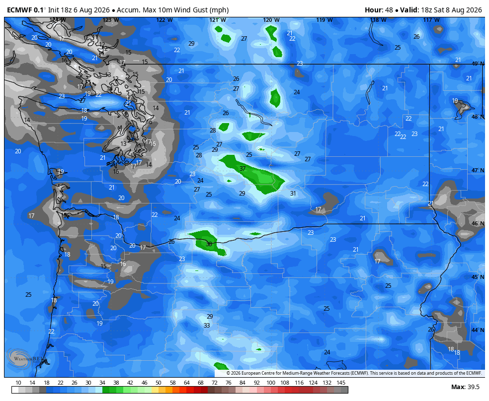
We do have some minor good news though: Those wind speeds are a bit slower than last Saturday’s 40-45 mph gusts. As a result, this Red Flag Warning is not tagged with the “Particularly Dangerous Situation” event that last week’s historic event had.
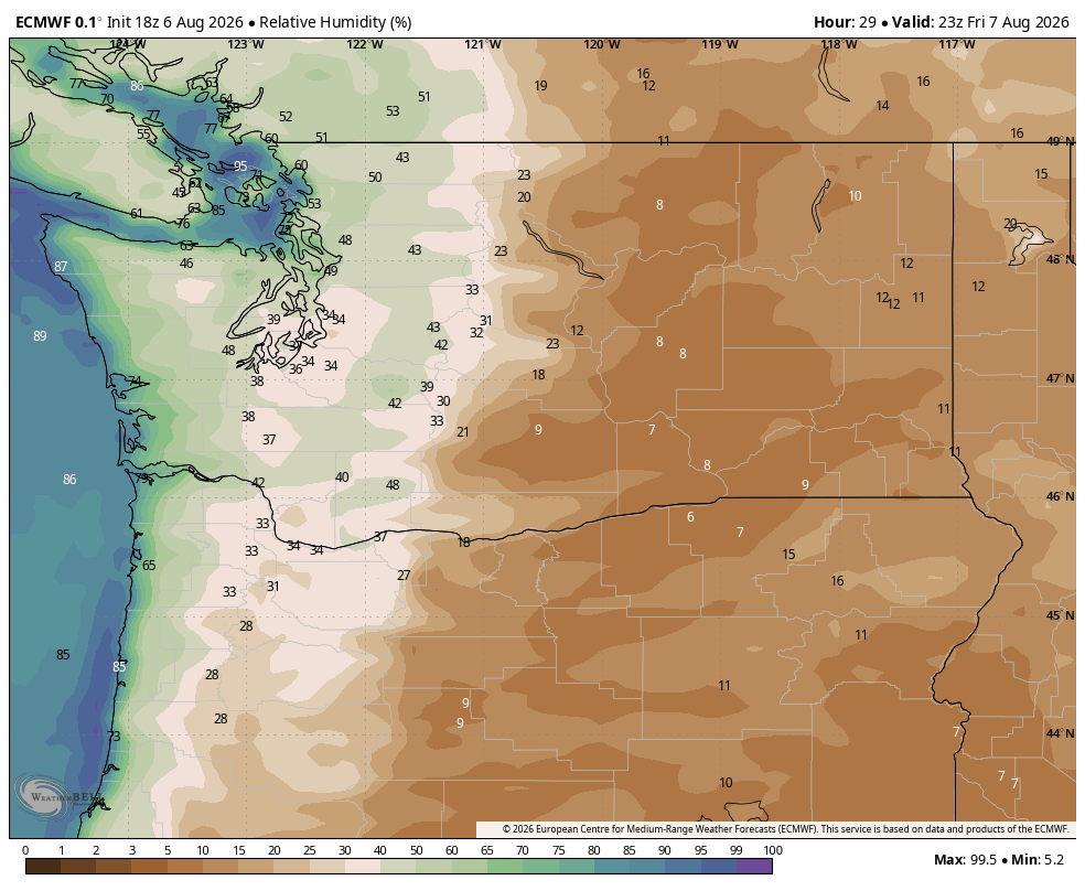
MORE: What does the “Particularly Dangerous Situation” Fire Weather Warning mean for Eastern Washington?
Also of note, NOAA’s Storm Prediction Center has that Eastern Washington warning area in a Level 1 out of 3 “Elevated” fire risk for Friday. Last week’s event already had the highest Level 3 “Extreme” alert, two days in advance.
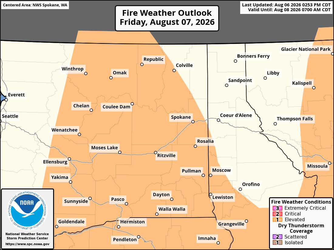
But even though this fire weather event doesn’t look quite as harrowing as last week’s — which was historic — it is still dangerous. Fires are still very easy to start with the dry vegetation, and gusty winds with low humidity can still promote explosive growth, plus increasing spread of current fires.
Suffice to say, everyone in Eastern Washington needs to be hyper vigilant again. The tragedy of Spokane illustrates how fast a day can go from calm to catastrophic in these situations.
WHEN DOES IT ALL GET BETTER?
For Western Washington, it actually looks like a pleasant stretch of weather coming up with smoke-free sunshine and highs in the upper 70s to low 80s at least into the middle of next week, with westerly breezes keeping the smoke away. If wildfires weren’t such a daunting part of the current landscape, we’d be crowing about how an amazing stretch of weather is in the offing.
For Central and Eastern Washington, it’s better, but still not great. The winds will die down during the day Saturday and remain generally light the rest of the week. The forecast over there isn’t as hot as this past week — more so “normal” August heat. And no current signs of the imminent return of the east winds that pushed all the smoke up against the eastern Cascade foothills. Which is good because it looks like there’s a new fire up there.
Most of next week will feature lighter winds and more localized smoke closer to where fires are burning, with some smoke drifting downwind to the east. There is no solid signal in the long range models yet of either a return to the offshore wind-fueled heat, nor the cold low pressure troughs that bring the blast of west winds.
The good news in that regard is we might effectively get to “bleed the clock” and knock off some days of summer without making things worse on our inevitable march toward the wildfire-squelching rains of autumn.