Heat and wildfire smoke set to return to Seattle and Western Washington this week
 Scott Sistek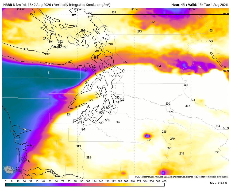
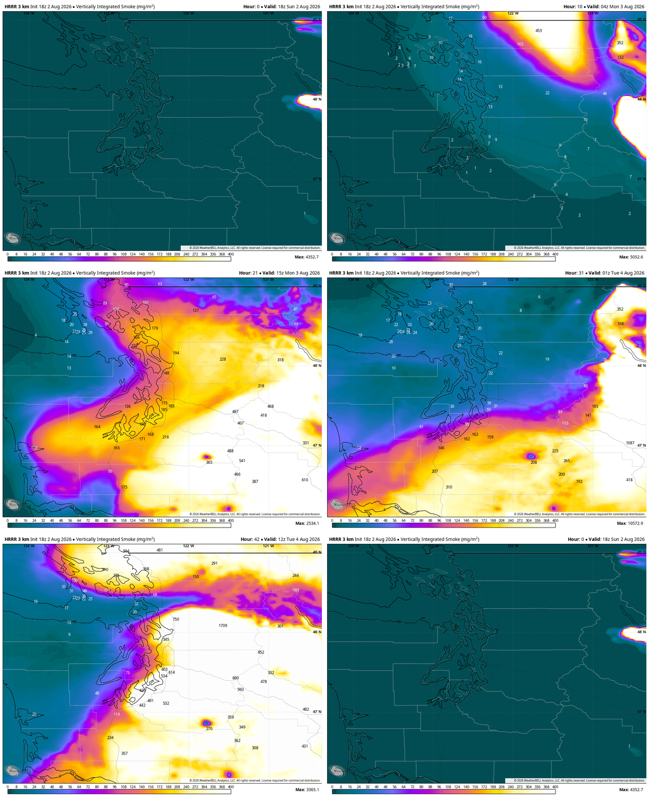
HRRR Smoke map (WeatherBell version) showing predicted smoke (combined entire air column of 0 to 80,000 feet altitude) for late Tuesday morning over Western Washington. (Brighter colors = thicker smoke)
(I know this is super long but it’s a lot to discuss, but here’s a TL;DR/ “Too Long; Didn’t Read” synopsis: The forecast has changed for the worse this week across Western Washington with scorching heat about to mix with what looks like our worst bout with wildfire smoke of the year so far. Relief won’t come until the end of the week. Eastern Washington will stay hot and dry but will relatively calm winds until the end of the week.)
So to start, I’ll prepare you ahead of time by saying this forecast… does not really have a whole lot of good news in an August that has already started off on the wrong weather foot.
I know last week I wrote about how it looked like in the extended range forecast models that onshore flow would keep Seattle and Western Washington right in that temperate zone of upper 70s to low 80s. Even called it the “Goldilocks Zone.”
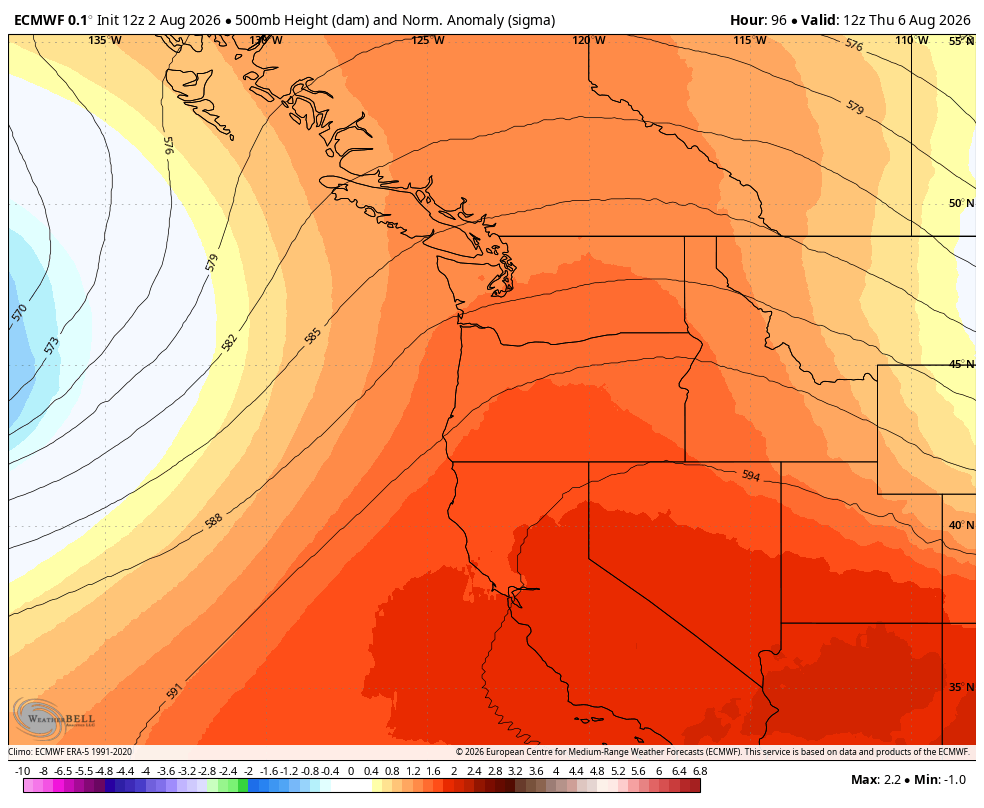
But latest projections show high pressure currently dominating the Southwest will now barge its way up into the Northwest after all, bringing along a thermal trough that conspire to not only heat us up, but turn off our cool, clean ocean breezes and instead veer offshore and start blowing smoke into the region.
In fact, this is looking like the worst bout of smoke Seattle and Western Washington will have dealt with so far this summer, with much higher concentrations of low elevation smoke than we’ve experienced yet this year.
The transition will begin in earnest Sunday night as the last remnants of the low that brought this weekend’s clouds and showers exits the region. High pressure will quickly begin to push into the area, starting a rapid warming trend as we kick off the work week.
MONDAY: SOME HEAT AND A LOT OF SMOKE ALOFT
High pressure begins getting established and winds will start to blow in from the north, warming us up into the mid-upper 70s in Western Washington — not bad yet on the heat.
BUT that wind shift will first start to blow in a thick layer of smoke from Canada.
READ MORE: Here is how to find and read wildfire smoke forecast models for Seattle and the U.S.
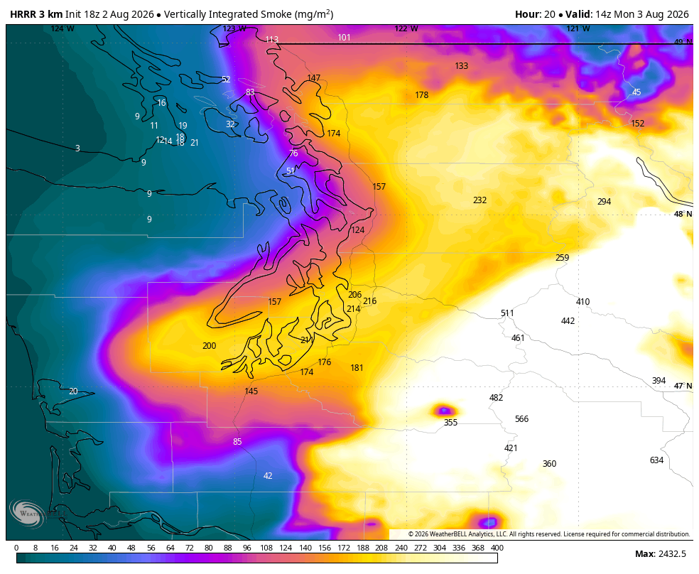
For Seattle and Western Washington, it looks like for much of the day this smoke will stay aloft so it will be increasingly hazy/smoky from the north but our air quality should hold for most of the day.
TUESDAY: HOTTER WITH SMOKE COMING CLOSER TO THE GROUND
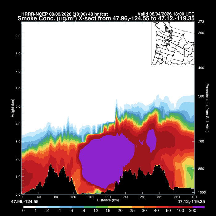
Actually Monday evening and night the smoke will start coming closer to the surface, and Tuesday will feature smoky “sunshine” with likely degraded air quality.
At this point, it looks like we’ll get only a moderate amount of near-surface smoke in Western Washington to start, but getting potentially worse as the day progresses.
(Much worse in Eastern Washington — especially along the eastern slopes of the Cascades, — and in Oregon.)
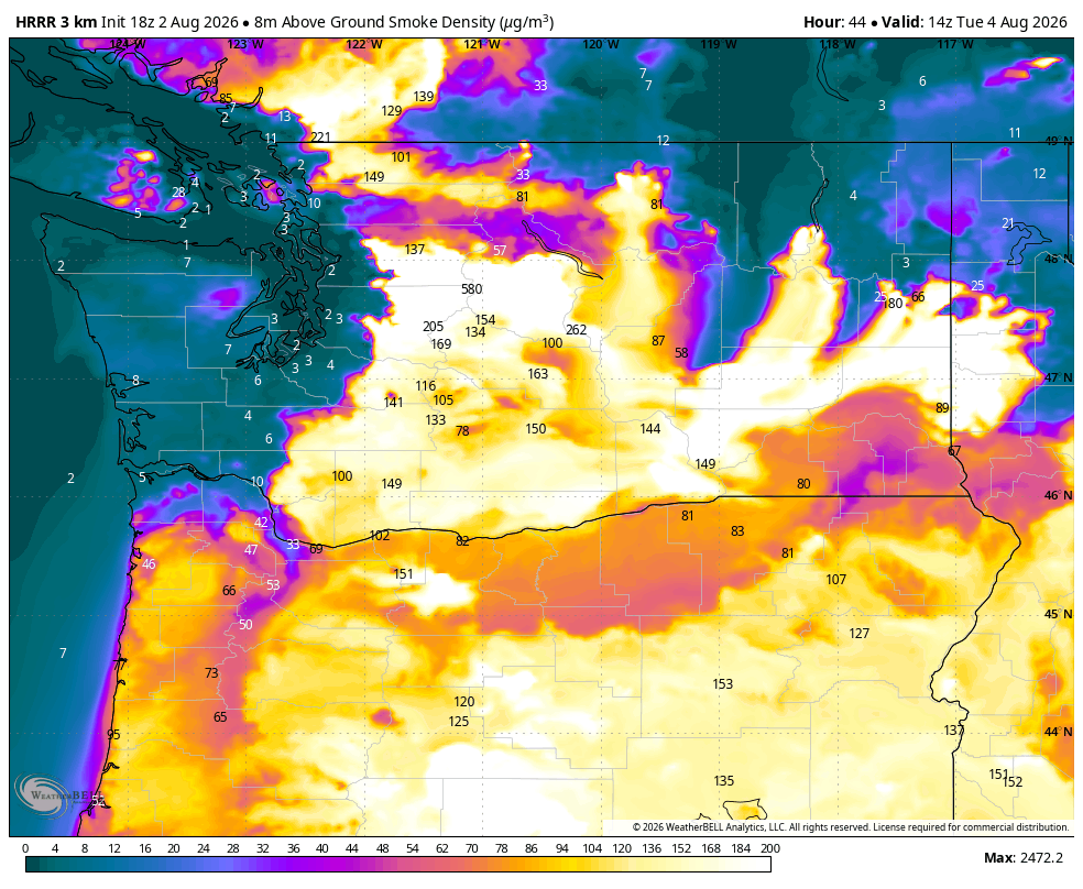
Here’s the entire smoke forecast loop up through midday Tuesday:
And here’s a cross section of what the smoke looks like as of midday Tuesday:
Highs will likely reach the low-mid 80s around the Puget Sound/Western Washington area.
WORST DAYS: WEDNESDAY AND THURSDAY WITH HIGH HEAT AND POSSIBLE THICK SURFACE SMOKE
This is the peak of our heat wave, and under smoke-free circumstances, these would be our two hottest days under crystal clear sun as dry, easterly winds hold our ocean breeze back and we sweat in the 90s.
Wildfire smoke is expected to return this week. Smoke likely will be aloft into Monday with hazy skies. Smoke may then reach the ground later Monday-Tuesday. This video shows the total smoke forecast (measure of all smoke in atmosphere). Monitor your air quality agency for info! pic.twitter.com/jmKOiriPsd
— NWS Seattle (@NWSSeattle) August 2, 2026
Unfortunately, this is not smoke-free circumstances. This east wind is only instead going to now carry even more thick smoke from Eastern Washington into Western Washington.
The high-resolution smoke forecast models only predict out 48 hours in advance, so as of this writing, they only show maps out to midday Tuesday. But the last few images suggest a huge influx of thick surface smoke was imminent. Not the cliffhanger you want to see.
WHAT ARE THE POTENTIAL IMPACTS?
We could see areas of poor to flat out unhealthy air quality around the Puget Sound area and Western Washington. Outdoor activities will be greatly discouraged. Those of you who are highly sensitive to air quality, see if you can make plans to find an air conditioned place to stay during these days. I’m hoping the cities will set up some places to go. Libraries are usually a good bet.
RESOURCES:
* Washington Dept. of Ecology Smoke Blog (Current Air Quality / Smoke Forecasts)
* InciWeb Washington (Latest Wildfire Info)
* Washington Weather Chasers Facebook Page (Wildfire Coverage)
What’s worse (I know! So sorry…) is that with the heat it makes for a terrible choice for those who do not have air conditioning — do you want the windows open to keep cool, or the windows closed to keep the smoke out?
The ONLY teeny tiny silver lining is if thick smoke is around and the sun is blotted out, temperatures would stay a little cooler than they would be under typical sunny circumstances. We’d likely be looking at low 90s both days in Seattle under blue skies; but maybe we can hold in the mid-upper 80s instead. Yes, not much solace. (Note, automated forecasts like your weather apps and raw model outputs are not going to factor the smoke and overestimate the high temperatures.)
Some of the very worst areas for air quality will likely be along the eastern slopes of the Cascades as some smoke “dams” up against the mountains, and being up aloft in the mountains (you won’t be able to “climb” above it). But smoke will be carried through the passes and even over the tops of the Cascades into Western Washington.
IS THERE ANYWHERE TO GO TO NEARBY TO GET AWAY FROM THE SMOKE?
It’s going to be tough to find any relief across the Pacific Northwest. The coast will afford cooler temperatures and perhaps not quite as dense smoke as being closer to the Cascades, but it still looks smoky there eventually. The entire state of Oregon from the northwest tip Astoria to the southeast corner near the Nevada border looks covered too.
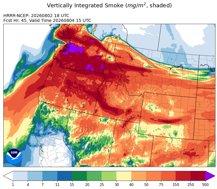
You’d really need to get out of the West. The Southwest may be smoke free but they’re in a big heat wave with 110+ temps in some inland areas.
WHAT ABOUT CENTRAL AND EASTERN WASHINGTON?
Smoke was localized to downwind east of the current fires Sunday but will spread across the rest of Eastern Washington Sunday with as the wind shifts and some smoke merges in from Canada.
By Monday, Eastern Washington will be a mix of homegrown and imported smoke that will then spread west as the winds shift back toward from the east, eventually covering the entire region. It will likely stay very smoky through the week.
WHAT ABOUT THE CURRENT WILDFIRES OVER THERE?
Aside from the smoke, Eastern Washington is reverting to its usual August summer pattern of very hot days and relatively dry but calm winds that parched the region to begin with.
Highs will be in the 90s all week but winds should remain mostly light through Thursday (though they do pick up a little each afternoon.)
WHEN DO WE FIND RELIEF FROM SMOKE AND HEAT??!?
For Western Washington, it looks like relief should start to come in on Thursday night as the ridge begins to shift inland, carrying the thermal trough with it.
That will allow the winds to shift back to the west, bringing cooler — and cleaner — air from the Pacific Ocean. (However, in some smoky summers past after east wind events some smoke had blown out over the ocean, only to come back over us during the wind shift.) By Friday and the weekend, it *should* be much better on the west side.
Unfortunately in the “bad news keeps coming” department, this will once again bring gusty winds back to Eastern Washington — likely on Friday at this point.
Hopefully not quite as critical fire conditions as Saturday, which were historic, but for firefighters it’s an impossible choice of weather this August of either hot and dry or not-quite-as-hot and very windy.
WHAT DO THE LONG RANGE MODELS SAY NOW?
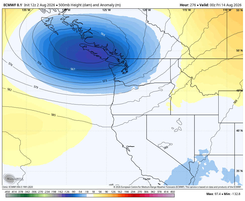
You’ve read this far. How about SOME GOOD NEWS?!?! It is at least trending toward staying away from the hot weather next week and keeping westerly winds which would keep the west side clear.
There’s even a few hints of a few showers out there sometime as we get far into next week.
Also doesn’t look like there is any lightning predicted in Eastern Washington for the next two weeks.
Going forward though, any time you see a high of 85 or hotter in Seattle though, smoke may be a factor too as that heat likely comes with an offshore wind shift.
In the meantime, hang in there everyone, give a hand to those who could use one, and keep those affected in Eastern Washington in your thoughts.
MORE TO READ:
- What does the “Particularly Dangerous Situation” Fire Weather Warning mean for Eastern Washington?
- Seattle nearly had its hottest rainy day on record
- As remnants of Tropical Storm Elida loom, why Seattle never gets ‘real’ tropical storms
- Cool ‘fire rainbow’ clouds grace sunny summer skies over Western Washington