Flood Watches issued in Cascades as multi-day Pineapple Express soaks Seattle
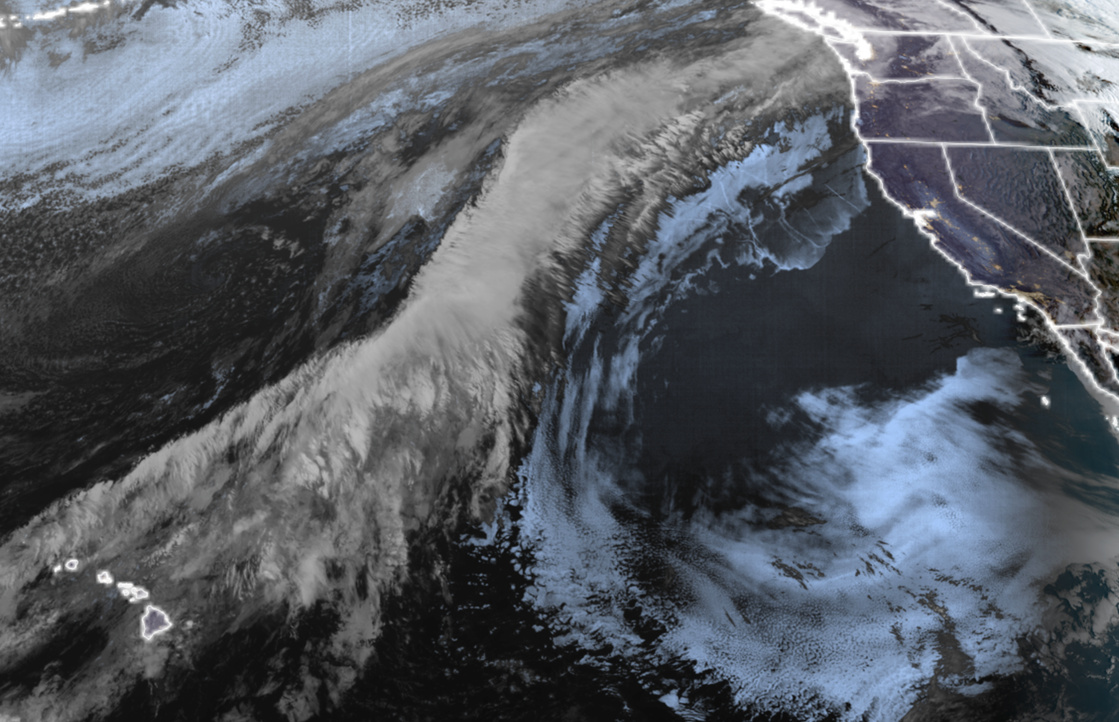
GOES-18 Satellite image on March 17, 2026 showing Pineapple Express plume stretching from Hawaii into the Pacific Northwest.
A multiple day Pineapple Express-type atmospheric river is here. And while it’s been shifting a little north and south at times so far, overall, the very wet forecast remain on track for all of Western Washington.
As mentioned in earlier forecasts, this won’t go down among the more intense Pineapple Expresses we’ve had, but it does garner some impact concerns based on its longevity.
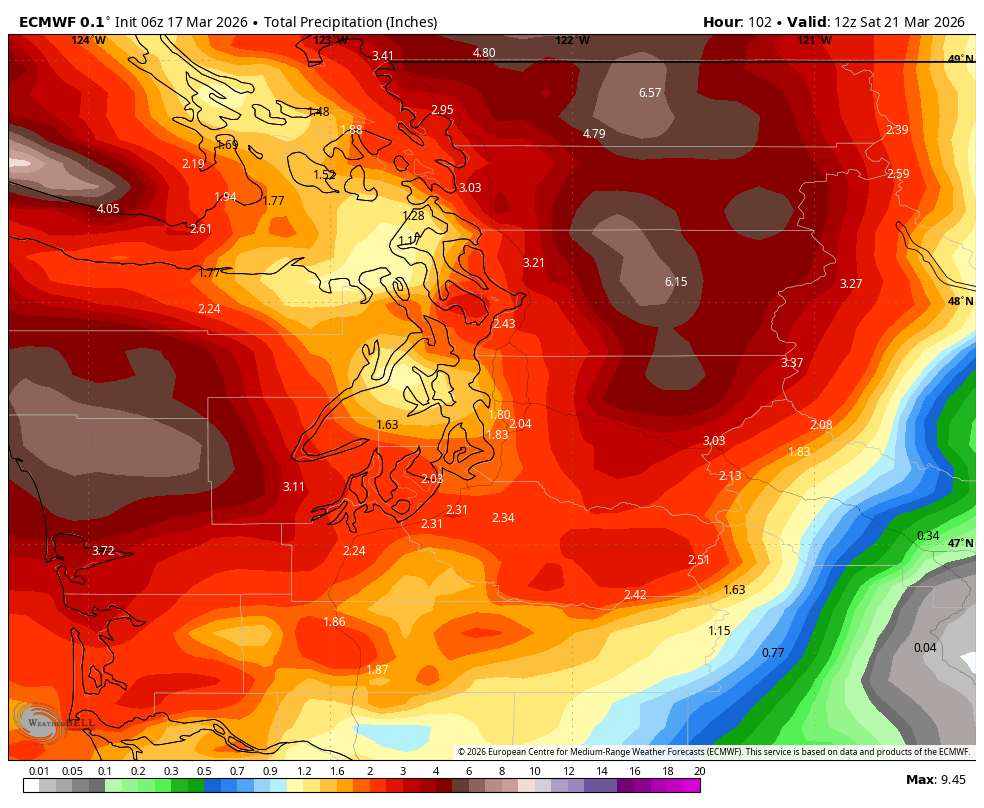
The general forecast keeps steady rains through Friday, with heavier intensities in the mountains and lighter rains at times in the North Sound lowlands due to the Olympic Rain Shadow. With high snow levels around 8,000+ feet, we’re looking at about 5-7” of rain in the Cascades and Olympics total through the week (higher ends of that range more so the northern Cascades) and about 1.5-3” in the lowlands. The warm temperatures will also lead to some melting of all that new snow that just fell in the mountains last week.
Thus, new as of Tuesday morning is that Flood Watches have been issued for rivers in the North Cascades (technically rivers in King, Snohomish, Skagit and Whatcom Counties; plus Mason County for the Skokomish.)
Looking at NOAA’s river forecast page, several rivers have seen their forecasted crests increase, with many now predicted to go over flood stage.
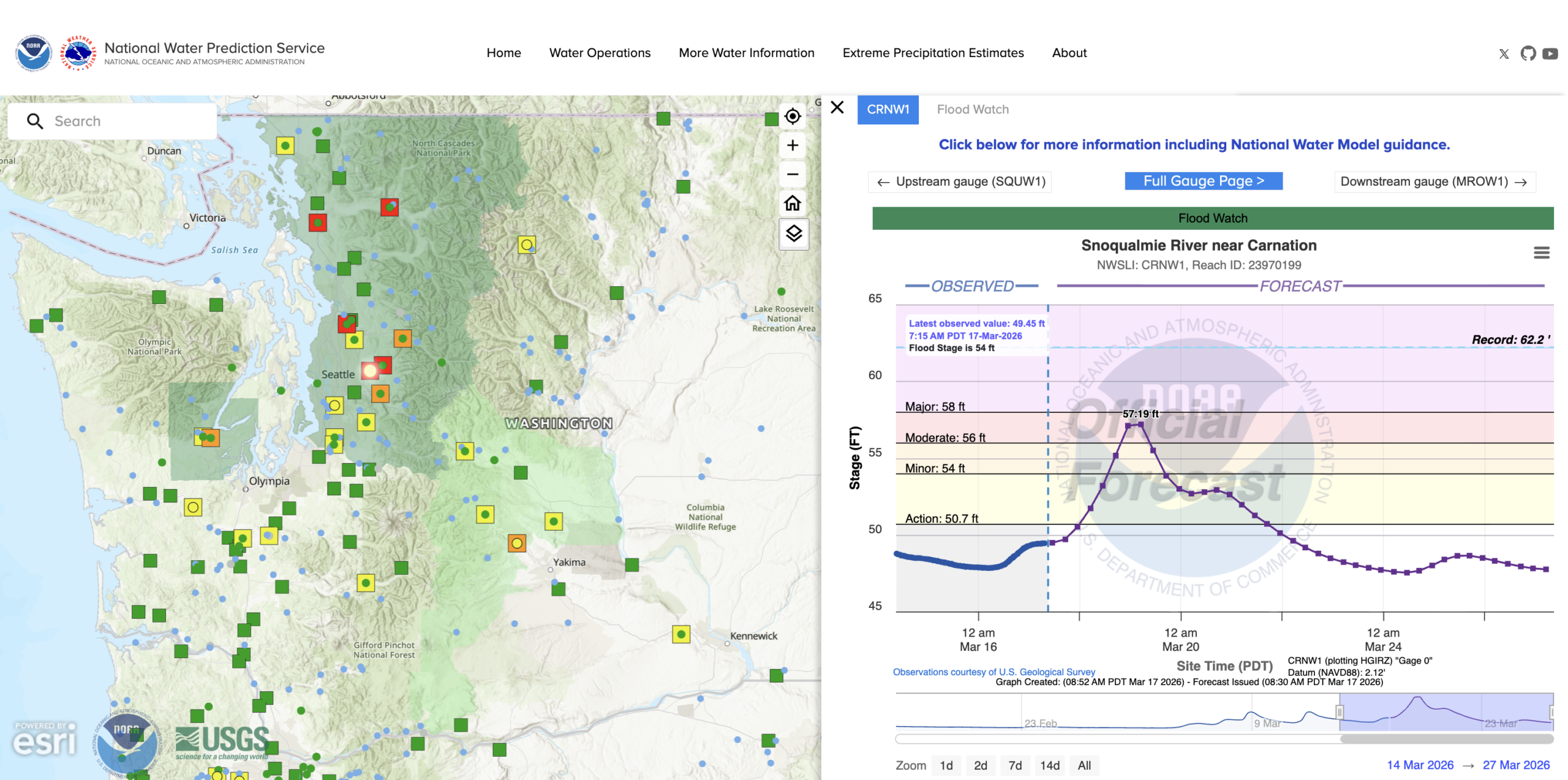
The Skagit, Snohomish, Tolt and Snoqualmie are now all predicted to reach moderate flood stage (red box) later this week (crest times vary depending on how close the river gauge is to the mountain source and how far and long it takes the surge in water to move downstream.)
These heights are more in line with “typical” flooding events we see a few times a winter and for like the Skagit and Snohomish, still a good 6-7 feet BELOW the crests from December, to give an idea how intense that flooding event was.
Rivers south of King County are still in the green or at worst, “action” stage which means running high at 80-100% of flood stage, but not reaching flood stage. Of course, good to keep an eye on them too.
The lowlands likely won’t see much impacts from the storm aside from just… incessant dark gray. Natural sunlight will be in short supply this week, so those of you who are sensitive to darker skies will want your extra lights handy.
And (sarcastic mode on) I’m sure the daily Seattle-area commutes will handle the steady rains juuuust fiiiiiinnneeee, so may have to dip into the budget and upgrade to venti coffees for the week, and maybe spend a few moments updating the playlist with fresh songs or podcasts.
The Pineapple Express seems to let up around later Friday with what passes for a break (as in just scattered showers) over the weekend. More rain looms next week but it appears to be more typical weather systems with snow levels back at least to the middle mountain elevations.
So I noticed you have a quick and dirty version for your more…AD readers. What if, and only what if, you added a sailors blurb to the weekend forecasts? I could add like 8 people to reader list right now. 🤣. But seriously, it could be hundreds or thousands. We crave good weather forecasts. Lately, we live and die by HRRR models.
Just the Puget sound area.
Wind and direction. Wave state we could figure out.
Just a thought.
Always a fan!