Pineapple Express may last for days in Seattle next week, sapping fresh mountain snowpack
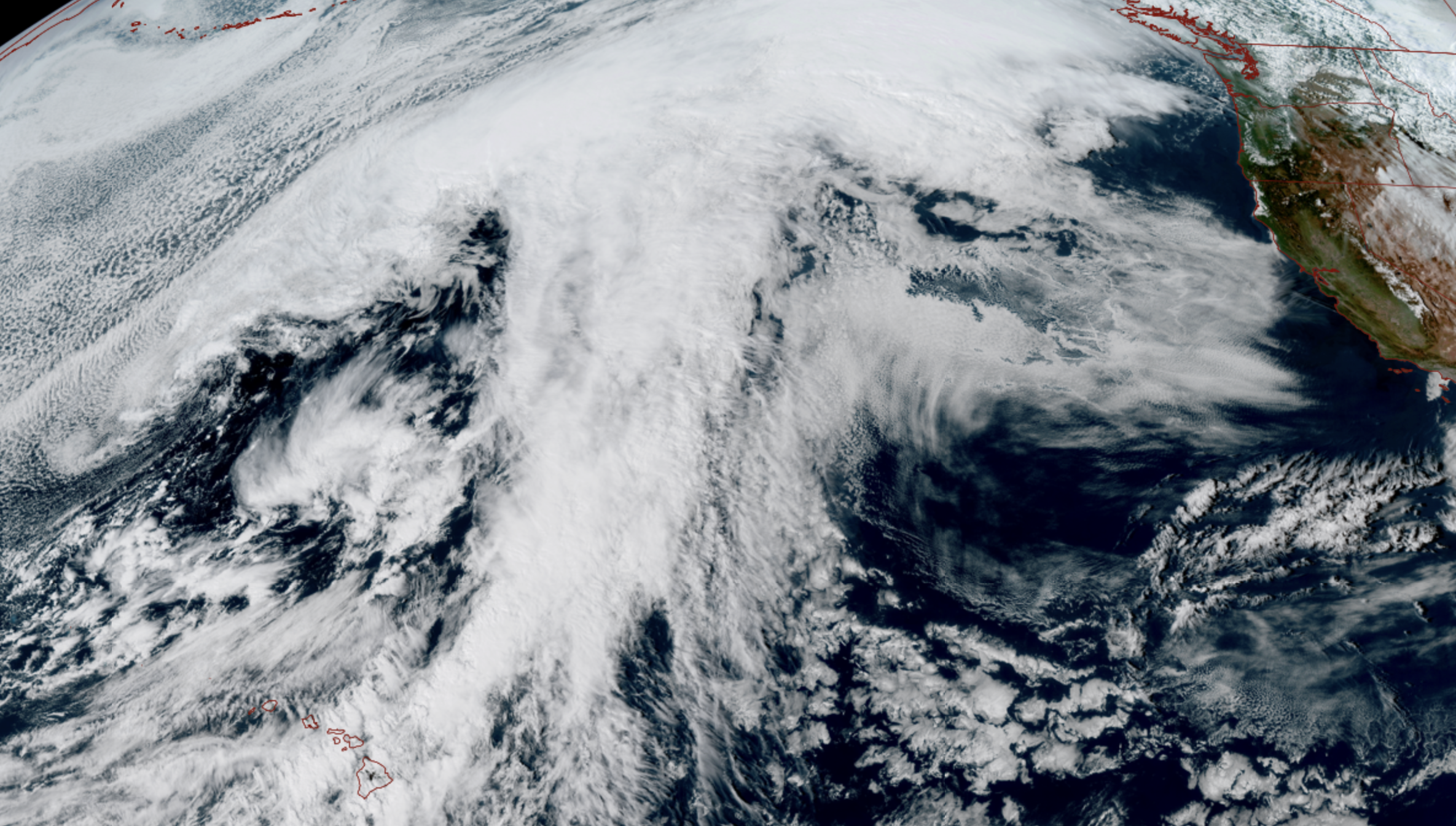
GOES 18 satellite image from March 14 showing large plume of moisture starting from near Hawaii and spanning a large swath of the Pacific that will gradually take aim at B.C. and then Western Washington next week.
It’s already been a pretty notable week of weather here — Seattle just had the windiest (52 mph), snowiest (3.0”), and 2nd-rainiest (1.22”) day of the stormy season (Oct. 1-March 31) — all within about 48 hours.
Next week is saying: Hold my latte.
[First, this is another long post, so for the “Got better things to do than read Scott’s ramblings” crowd: It’s going to get really rainy here around Seattle again from late Sunday through the week, only this time it’s warm rains with highs near 60.]
As someone who now works a “day job” in national weather, it’s stunning to see what’s in store for not just us, but the entire nation this week, which includes: A multiple-day atmospheric river, a potentially historic heat wave (Desert Southwest), a potentially historic blizzard (upper Midwest into the Great Lakes) and while not historic (we hope), a rather daunting severe weather set up for the Southeast and mid-Atlantic, right before another arctic air mass settles in over there.
“US forecasts blizzard, polar vortex, heat dome and atmospheric river all at once,” a recent Associated Press article headlined. (Well since then, we’ve added in “bomb cyclone” to the Great Lakes chaos.)
OOOH, CAN WE GET THE BLIZZARD?
No. Up here in the Northwest, we drew the “atmospheric river” straw, so I’ll focus on that. Yep, it’s about to get warm and very wet again around here, just after we finally restocked the mountains.
The WSDOT reports Snoqualmie Pass received 42.5” just in two days, and 64.5 inches (5+ FEET!) since March 9. Stevens Pass got 37.5” in two days and 80.5” since March 9! (HEY! That model run that predicted 80-100” at Stevens Pass — not too far off!)
But soon, snow levels are about to rise up to 9,000 feet, a lot of that snow is going to melt and/or wash away, and all I can think about is the sad snowbot from the 2010s era Staples holiday commercial.
(Weeping… Weeping…)
ISN’T IT SUPPOSED TO BE LIKE SUPER HOT IN THE WEST THIS WEEK?
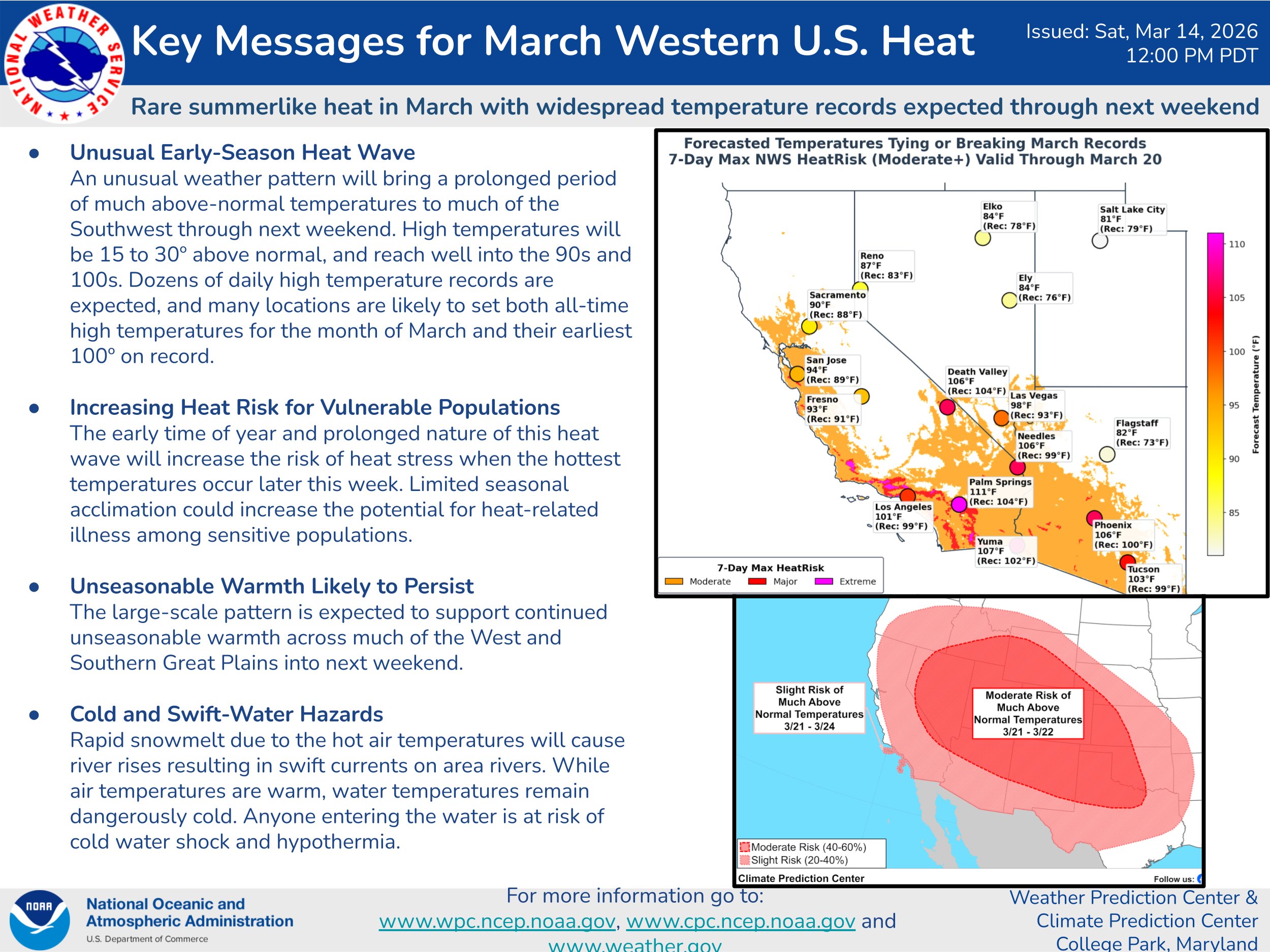
Yes, you may have heard that there is going to be some historic heat across the West as a massive ridge of high pressure that’s already baked California and the Southwest with near record temperatures the past couple days now is going to get even HOTTER later next week as a heat dome intensifies.
That whole pattern is its own incredible mess with severe implications that I’ll write about that more in a future post. But to give a small idea: Phoenix has hit 100 degrees one before in March in 1988. The forecast this week has it over 100 for 5 consecutive days — essentially breaking their all-time hottest March day on 5 days in a row and two of the days they might surpass their hottest April day on record too (105).
Shades of the record-smashing power of our June 2021 heat wave.
As it pertains to Western Washington: We’re too far away from the figurative stove to bake with them, but that heat dome will act as a conveyor belt to shuttle that moisture right along the outer edge of the anchored dome… and funnel it right into Western Washington.
Bottom line: Not sunny and hot, but warm and rainy — temps may still reach 60 around Seattle next week. Guess it could be worse?
HOW MUCH DRY TIME DO I GET TO WALK MY DOGS THIS WEEK?
About 10 hours. Sunday will start dry, but will see rain developing late in the day as the stream of moisture roars in from the tropical Pacific. I says “roar”s in because if you look at the first forecast map showing the tropical moisture stream, it always looks like we’re about to get attacked by the Loch Ness Monster (or Dino…).
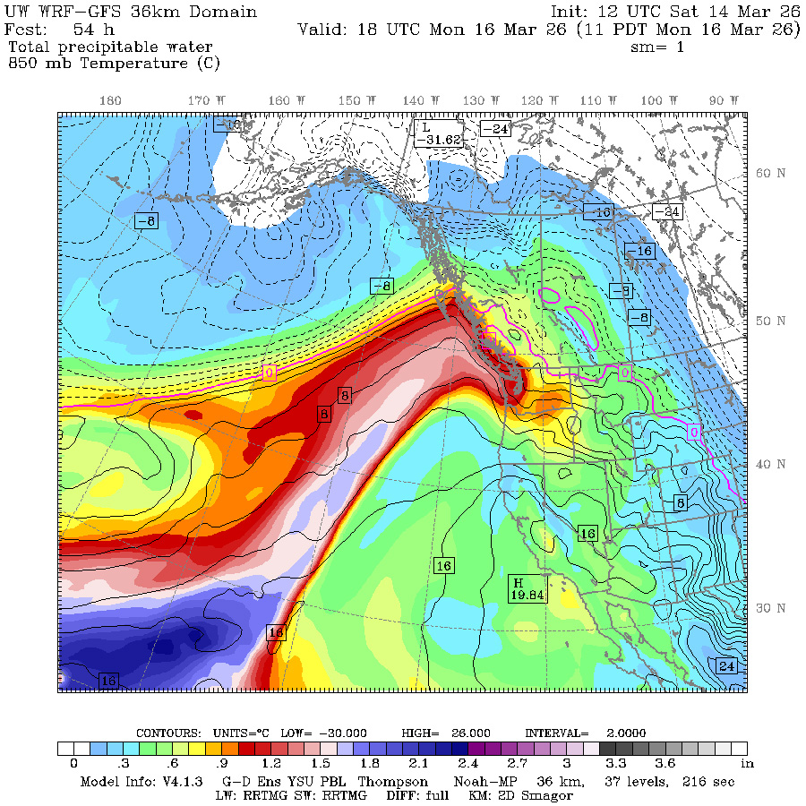
The plume at first will aim at British Columbia Sunday into Monday and we’ll get some light to moderate rain on the southern edge of the stream. But the forecast models are coming into better agreement that the plume will drift south and focus on Western Washington from Tuesday through… Friday or even Saturday(!), keeping a near steady stream of rain coming into Western Washington. Of that period, Wednesday is looking like the wettest and breeziest day with a low pressure wave coming along the stream.
The moisture is tapping into some of that abundant moisture that has been plaguing Hawaii this past week — if you haven’t heard, it’s been a relentlessly stormy week there with unbelievable rainfall totals (3 feet plus already on the Maui volcanoes with more to come) plus flooding and wind issues.
What we know: Haleakala last 24 hours over 32″
What we show: Nam shows 31″ for the NEXT 24 hours. and over 70″ for the next 48 hours. With potentially MORE after that…. Let’s see how the model does. #hiwx pic.twitter.com/bRSx586hxp— Michael Snyder (@SeattleWXGuy) March 14, 2026
And now some of that moisture will make its way here (which is why I was calling it a “Pineapple Express” which is basically an atmospheric river but with Hawaiian origins.)
The good news is, while this Pineapple Express will be of very long duration, the intensity isn’t too extreme — at least as of current projections. But even then just based on the long duration, it looks like by the end of the week we’ll have 2-4” of total rain in the lowlands and 5-8” or so in the mountains — especially the North and Central Cascades.
(A small bonus if it holds that it’s not the south Cascades, which just took the brunt of that last atmospheric river. It might have been snow around Seattle, but it was much warmer to the south and all rain in Portland into SW Washington this week and some rivers in the Chehalis basin are flooding.)
DOES THIS MEAN WE GET MORE FLOODING UP HERE?
Right now… the river forecast models are predicting that all of the who’s-who of typical winter river flooding basins — like the Snoqualmie, Snohomish, Skykomish, etc. — will reach “Action” stage — that would be getting within 80-100% of flood stage levels. But so far… no rivers are forecast to go over except the flood-prone Skokomish.
We’ll see if that holds; I remember in the December floods those forecasts started out optimistic too. At least this time the mountains have some snow up there to soak up some of the rain, unlike December. But this will likely but an unwelcome dent in the snow bounty we just received.
Bottom line: get up there to ski on Sunday and soak it in, figuratively, before you have to soak it in literally. It’ll likely be raining at most of the lower resorts much of next week. And those of you in the river plains, start getting your flood preps together now just to be ready.
CAN’T WE JUST DO LIKE THE COMMERCIAL AND GET THE STORM A CELL PHONE INSTEAD?
If only…
I’ll have more posts this week in the blog on the West Coast heat wave and its implications for snowpack and wildfires (spoiler alert: Not good.) And even worse, some of the inklings a strong El Niño could be in the cards for next winter. If you thought almost getting skunked for snow was exciting this winter….
Thanks Scott for adding the flooding stats in.
I drove up hwy 12 to white pass this weekend and the Cowlitz is quite high. I was worried about it flooding. Looking at NOAA, At Randle, it got to 17.38 ft on Sunday where 18 is minor flooding. Looks like it is down to a little over 12ft today.