Sight for sore eyes?: Blue finally appears on Seattle’s temperature outlook
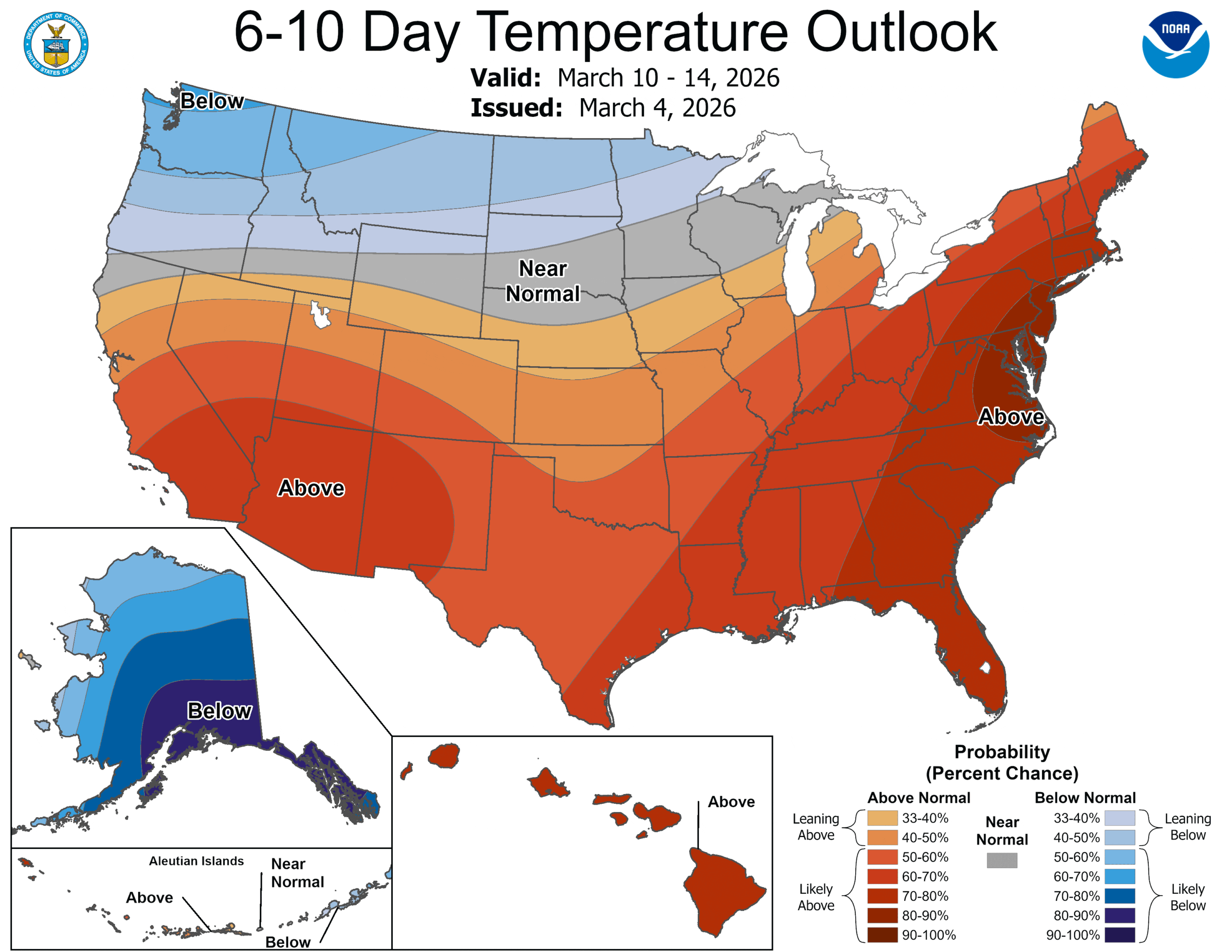
NOAA 6-10 day temperature outlook showing cooler than average temps expected in Washington between March 10-14.
Blue and green haven’t looked this good in tandem since the Super Bowl.
It’s been a looooong time coming, but Seattle and Washington are finally painted in blue shades on NOAA’s extended temperature outlook maps. That signals there is higher confidence of a period of below average temperatures.
What’s more, the precipitation outlooks are shaded in green, signaling confidence of above-average rainfall.
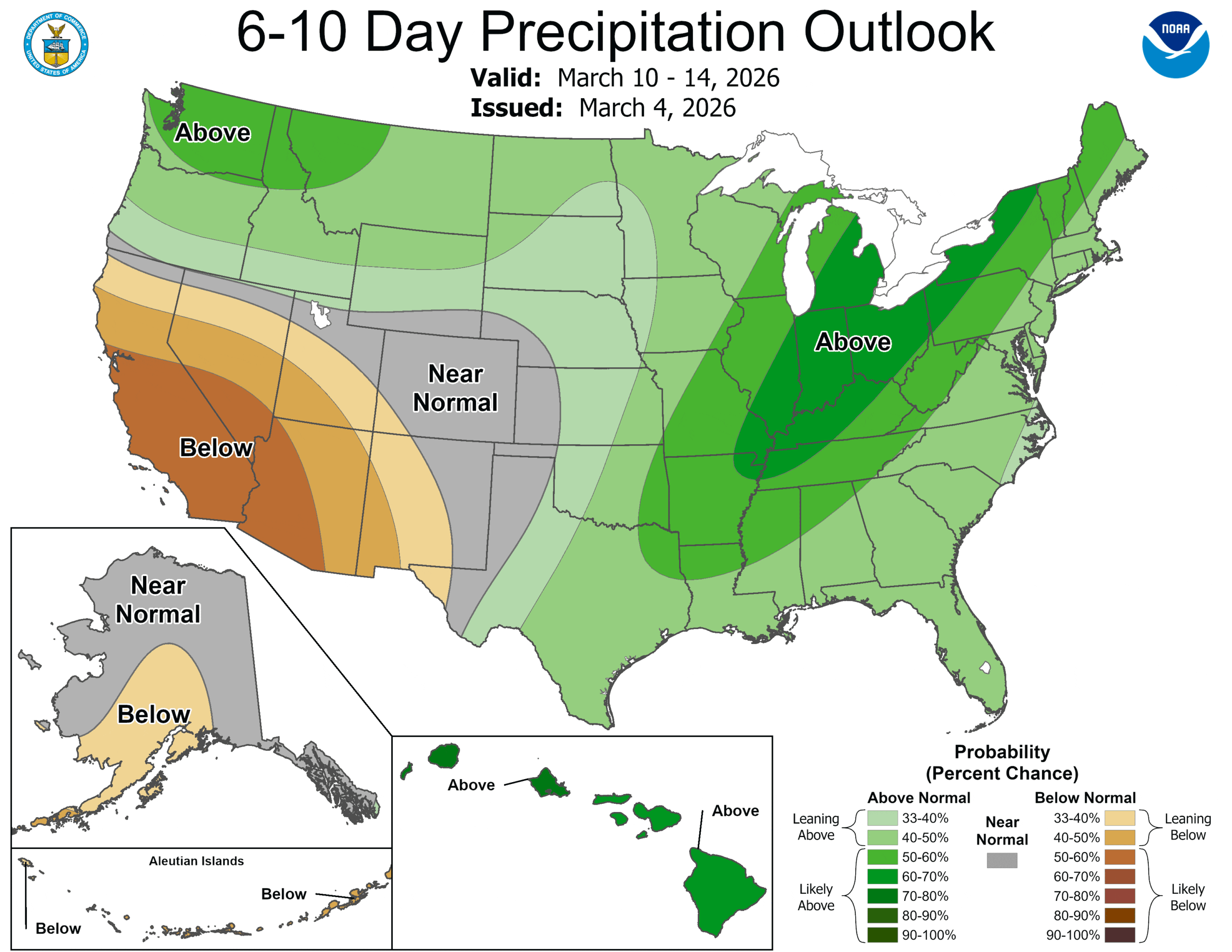
Put blue + green together and you get white….snow in the mountains and red…hearts on skier and snowmobiler’s emoji eyes 😍
Or, you could just glance at some of your favorite weather apps which may be showing a snowflake or a mix in the lowlands next week 👀
HEY WAIT, DIDN’T YOU JUST LITERALLY POST HERE YESTERDAY THAT WINTER WAS OVER?
Winter? Yes. Winter weather… 🤔
Meteorological Winter did, in fact, end on Sunday morning and it was the warmest La Niña winter on record, and tied for the 8th warmest overall.
But the mountain snow season goes into early April, and while it’s not in the actual forecast (despite that snowflake icon), it has snowed in the lowlands into March — even April!
(Fun Seattle weather trivia fact: Seattle’s earliest measurable snow (October 27) and latest snow (April 17) came in the same winter of 1971-72!)
As much as THIS La Niña winter has busted so far, in usual La Nina years, we can have little fringey lowland snow events in March. Maybe better late than never?
MY FRIEND SAYS THEY ALREADY MISS SUNNY AND 55 FROM THE PAST FEW DAYS. WHAT CAN I TELL THEM?
That, sorry, you can’t be friends anymore…
The short term forecast remains pretty typical Seattle (during a ‘normal’ winter) — a few weak to moderate weather systems coming through every 48 hours with showers on the days in between. Thursday will feature the leftover showers from Wednesday’s system; Friday and Sunday will see steadier light rains and breezy winds with leftover showers Saturday and Monday.
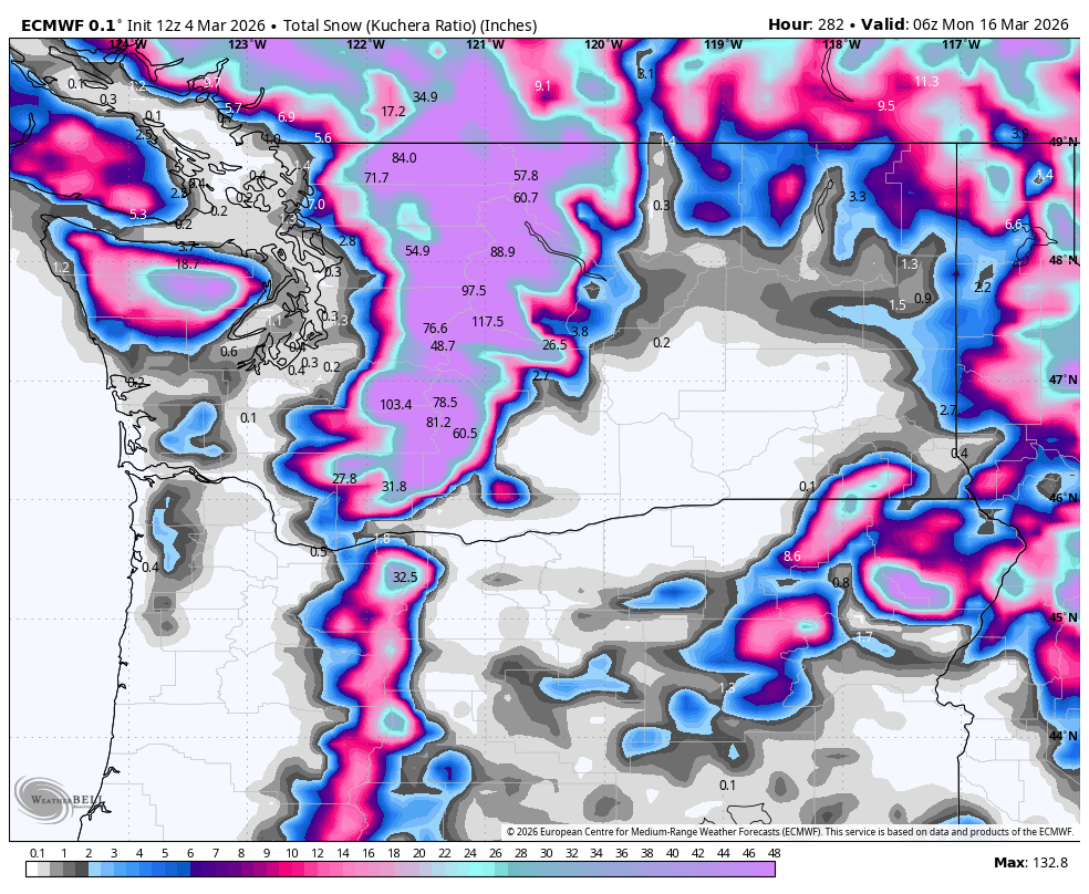
But a stronger — and cooler — system comes roaring in during the middle of next week. This will drop snow levels well below pass levels and with strong onshore flow, should be big mountain snowmaker.
I don’t think snow levels will be low enough for much of any lowland “fun” despite what your app might say — instead, a chilly, Seattle-type rain making it feel a bit more like late January than early March. But higher elevations might mix in a few snowflakes during the coldest parts the night, maybe.
“MAYBE” IS AS GOOD AS “YES” IN WEATHER FORECASTING, RIGHT?
Uh, suuuuurrrre….
But strong onshore flow with plenty of leftover moisture from the midweek storm will at least keep the snow going in the mountains through the rest of the week and perhaps into the following weekend.
Some of the gaudier snow models are painting 5-7+ feet of new snow added up from all the storms into the end of next week. WOO!
That March 14-19 period… skiers might already start coming up with how they’re going to be “sick” that week.