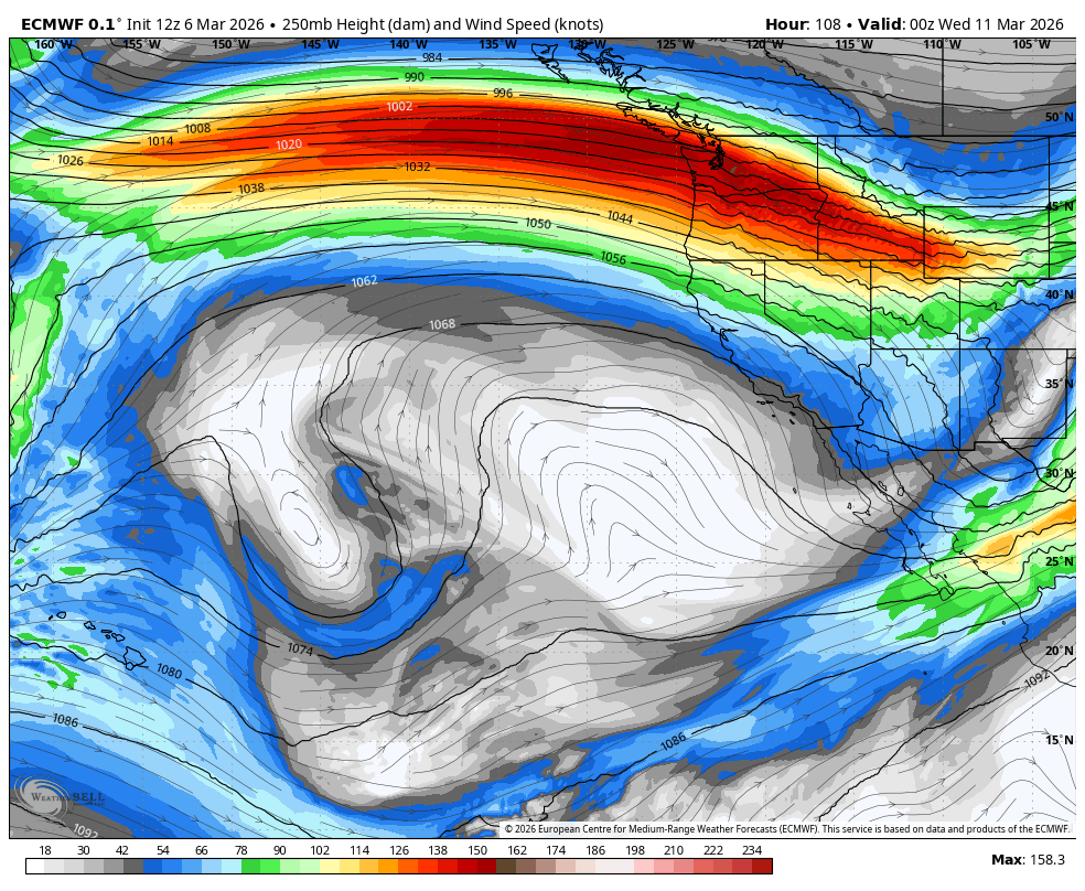
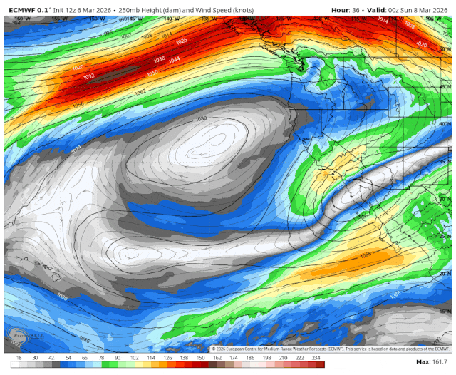
ECMWF 250 mb wind speed (at about 34,000 feet) showing a strong jet stream taking aim at the Pacific Northwest.
(TL;DR: LOTS OF MOUNTAIN SNOW! And…maybe some snowflake sightings in the lowlands. How much? That’s all you get for “DR”)
In the true sense of the title, are we about to swish a desperation heave at the buzzer (figuratively, not literally) to salvage our winter snowpack?
The forecast is looking more and more confident for next week in an atmospheric setup that just aligns the stars (again, not literally, that could be a mess…) to bring days of heavy snow to the mountains. And maybe even a few snow sightings in the lowlands?
A very strong jet stream is predicted to scream (again, not literal) across the Pacific Ocean on a bee-line (OH NO! Let’s hope THAT’S not literal) straight into the Pacific Northwest. (It’ll be interesting to see some of the trans-Pacific flight times from like Tokyo to Seattle with this kind of tail wind. Get here in 25 mins!)
We’ve sort of seen this before in the fall and early winter when we had all those juicy atmospheric rivers (OK, that term is at least… *mostly* literal) tap into warm, tropical moisture from the south near Hawaii and slam it into the Cascades and Olympics, dropping several inches of rain there amid very high snow levels.
But THIS time, the moisture is coming from the west and northwest — and while there is still plenty of moisture, we *don’t* have the warm, tropical air. In fact, this pattern will keep snow levels quite low — well below pass levels, even.
So if you ever wondered “What if we took those November and December flood storms, and it fell as mountain snow instead?”, next week will paint a good picture. (Still figuratively!)
HOW MUCH SNOW ARE WE TALKING?
The current weather systems that are coming through this weekend are still a little on the mild side so not much yet.
But once we get into next week, the mountain snow machine really gets going as that jet stream takes aim and feeds moisture into the mountains.
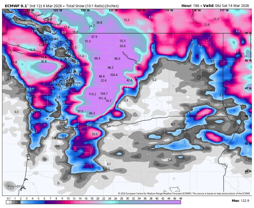
The ensemble forecast models are going pretty consistently about 4 feet or so at Snoqualmie Pass by next weekend, with Stevens Pass seeing totals of about 5-6 FEET. There’s one model run out there that, yeah it’s an outlier but I’m just going to put it here because dang it, we can dream right, showed just over 100” of new snow at Stevens Pass by the end of next week.
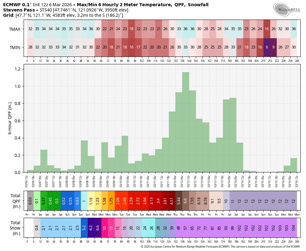
Suffice to say, a LOT of snow is coming to the mountains. Getting over the passes will become treacherous, especially Monday through Thursday and ESPECIALLY Wednesday and Thursday which look like the heaviest snow days.
HEY I STILL SOMETIMES SEE SNOWFLAKES DOWN HERE ON MY APPS
It is a bit amusing that March 8 is my unofficial end to Seattle lowland snow — at least where we can get big, widespread snows. And this year, March 8 may be when we start the closest thing we get to an extended “snowy” pattern in the lowlands, though do NOT get your hopes up.
Don’t do it. Just don’t.
(Hey, I see you! you’re still doing it…)
While this pattern is looking cool, it’s not cold. There’s no big arctic air mass roaring in from the Fraser Valley for all this to fall as lowland snow.
Instead, it’s somewhat similar to the last time it “snowed” in mid-February where snow levels were around 1,000 feet during the day then dropped to a few hundred feet during the coldest parts of the night.
So yeah, at night or in the early mornings we may see some wet snow or rain/snow mix and…. DANG IT! YOU’RE GETTING YOUR HOPES UP AGAIN, AREN’T YOU?
…But any snow won’t stick to much and won’t last long because afternoon high temperatures are still well into the 40s.
I know some weather maps you might be seeing around here online have shown some possible snow at times in the Convergence Zone areas and foothill snow belts, but again, any snow would be fleeting and melt quickly after the snow ends. This is… pretty much what passes for lowland snow around here after March 8.
What we do get here it the Puget Sound area lowlands? Days and days of bouts of steady rains flanked by scattered showers and, with the persistent northwest flow, frequent convergence zones (sorry Snohomish and northern King Counties.)
It’ll be pretty consistently breezy through the week too; nothing too wild, though some of the models say we’ll have to watch Thursday as the most potent of the storms comes through and could punch us up closer to 30-45 mph gusts.
The wet pattern runs off the end of the extended forecast, so look for raindrops on the extended forecast for a while.
(But at least no swarm of screaming, universe-altering bees…)