Atmospheric river storm to drench Northwest on Friday, then comes the weekend wind
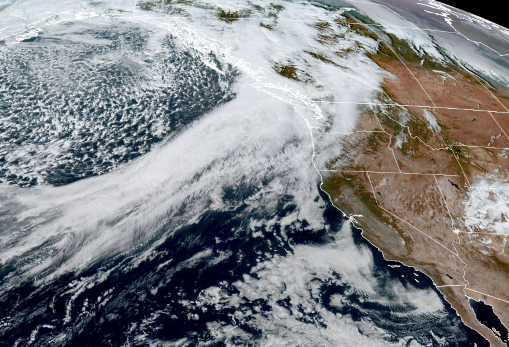
GOES 18 Satellite Image on Oct. 23, 2025. (NOAA / CIRA / RAAM-B)
Well, hellooooo October!
I’ve mentioned this before but my Dad served 26 years as a search and rescue pilot for the U.S. Coast Guard — 11 of them here at Pacific Northwest air stations; 8 more in the California Bay Area — and thus knows a thing or two about our local weather (which also makes for very informative check ins during zany weather days.)
He was always spot on that while summer starts to quickly fade in September, it’s the third week of October when the storms would ramp up and things start getting extra busy.
Busy indeed. We’ve already had a few stormy days as the cadence started to increase, but this week (which I guess is *technically* is still in the first full third week of October) now kicks off the full rapid-fire stormy season. And here we go…
While Thursday’s weather was tame, Friday we see our next atmospheric river-type storm arrive — though skipping ahead to the end a bit, this storm has lost some of its bite from what it was looking like in the long range forecasts several days ago.
It is still carrying some moderate to heavy rain and some gusty winds, but maybe just a half a tick above a shrug for impacts. We will see a rainy, blustery Friday as anyone who is commuting either Friday morning or afternoon will have a front row seat. And it’ll be a good view, free from any blurring of water on windows because let’s face it, you’ll just be parked on the freeway. Expected rainfall totals are about 0.50-1.00 inches in the lowlands and couple inches in the mountains (keep those storm drains clear of leaves!)
Wind gusts will be strongest on the coast and Northern Interior Friday morning, then the Puget Sound area will get a little punch of wind Friday afternoon, but gusts look to stay more in the 25-35 mph range — maybe a few gusts to 40, especially coast and North. Noticeable but not really bothersome. All in all, a very Seattle postcard day — just the kind the Chamber of Commerce doesn’t want you to send though…
SEATTLE: COME FOR THE RAIN, STAY FOR THE WIND?
The focus over the weekend turns to a little better shot of wind and mountain snows. For the lowlands, it’s obviously more just the wind. A low pressure center will swirl our way to trigger a period of gusty winds on Saturday but at this point, it looks like the low isn’t super organized (totally relate!) and isn’t like scary strong anyway.
But it’s still got enough oomph that I bet we still see some peak wind gusts around 40-45 mph, and thus get some Wind Advisories around here. Maybe a few rogue gusts to 50 along the coast and Northwest Interior but all in all, a pretty manageable “wind storm”.
Timing has the winds picking up along the coast Saturday morning, in the Northwest Interior by late morning/midday but holding off in the Puget Sound area until Saturday evening and night. For those heading to Husky Stadium — be glad they FINALLY scheduled a midday Saturday game! What a concept! I’d think you’ll get the game in and get home before those winds hit or if they do it’ll be late in the game or just during post-game tailgating festivities. Hang on to those canopies!
With the leafy trees that haven’t had “Nature’s pruning” from the summer yet, those wind gusts may be just strong enough to trigger some isolated power outages since the first good gust of the autumn season is the most vulnerable so be ready just in case.
For the mountain pass travelers, it’s all rain Friday and a 4,500-foot snow level Saturday, but snow levels will drop to around 3,500-4,000 feet Sunday and Monday. It’ll be on the rain-snow edge for Snoqualmie but Stevens should get some snow. It’ll be in bursts of showers not solid wall to wall snow, but be sure to check ahead.
The long range forecast for next week is — still stormy at times. Looks like chances for more atmospheric river-type storms and some additional bouts of wind at times. I’ll keep you posted! Or, just check with my Dad 🙂