Here’s the ‘script’ Super El Niño’s have used for past Seattle winters. Now, toss it out.
 Scott Sistek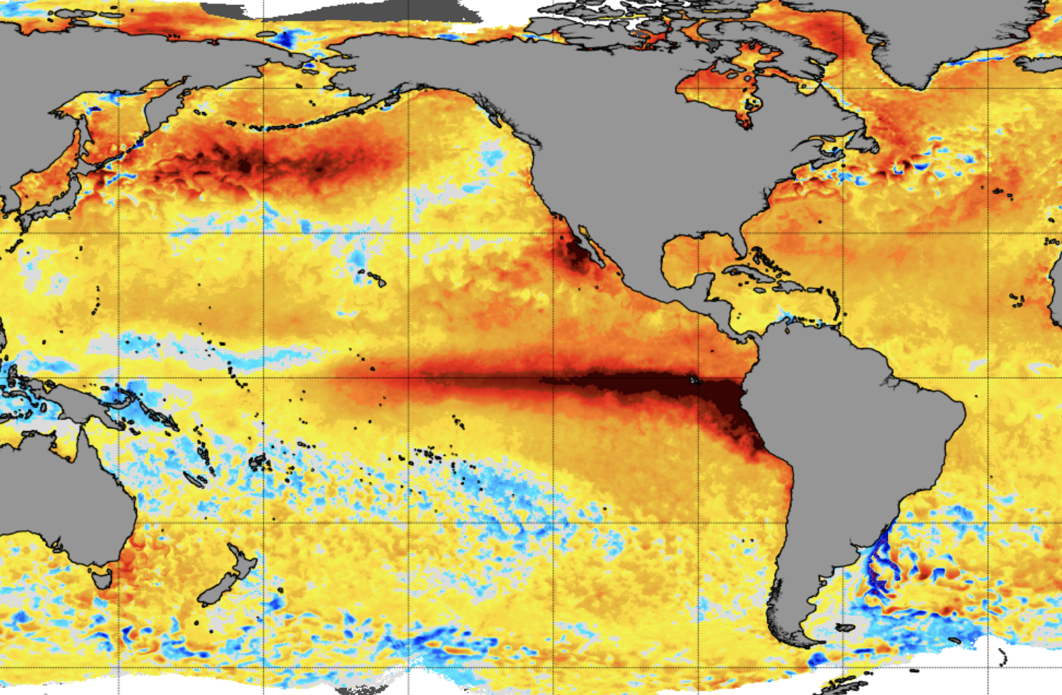
Current Sea Surface Temperature anomaly showing a distinct warm El Nino event under way (NOAA)
Another month, another prediction from NOAA solidifying that the current El Niño under way will become historic and potentially record shattering. But the main question many still have is: What does that mean for us?
For this blog, I wanted to tackle three items that might help grasp the situation at hand. First, I’ll go into not just the “what” but the “why” El Niño happens, second, I’ll dive into more details of the “scripts” the past three strongest El Niño’s have followed and what it meant for Seattle and Western Washington, and then I’ll finish it up with some notes about why the script this time around may be rather moot.
WHAT DRIVES THE EL NIÑO/LA NIÑA CYCLE?
El Niño is part of a 3-7 year cycle where the ocean waters in the tropical Pacific Ocean warm (and cool). We’ve learned that these changes in water temperatures have chain-reaction events on the general weather patterns around the world by first, shifting areas of storm build-ups in the tropics.
But what causes the shift? It starts with the tropical trade winds. If you’ve ever been to Hawaii or lived there, you know all about the trade winds, which typically run east to west across the ocean.
This process pushes warm waters to the west, piling it up against Asia and creating more showers and thunderstorm development. Meanwhile, the water getting pushed *away* from South America and the eastern Pacific cools, as colder, non-sun-warmed waters from the depths of the Pacific come to the surface.
El Niño occurs when these easterly trade winds weaken or even reverse direction. As far as western North and South America are concerned, that allows warmer waters to slosh back to the east, dually transporting warm waters toward South America but also shutting off this cooling process from drawing cooler water from the depths.
The sea surface temperatures climb above average.
And these warmer waters in turn, through cascading effects, pull the jet stream in the eastern Pacific farther to the south — moving it away from aiming storms at the Pacific Northwest, and instead aim them at California.
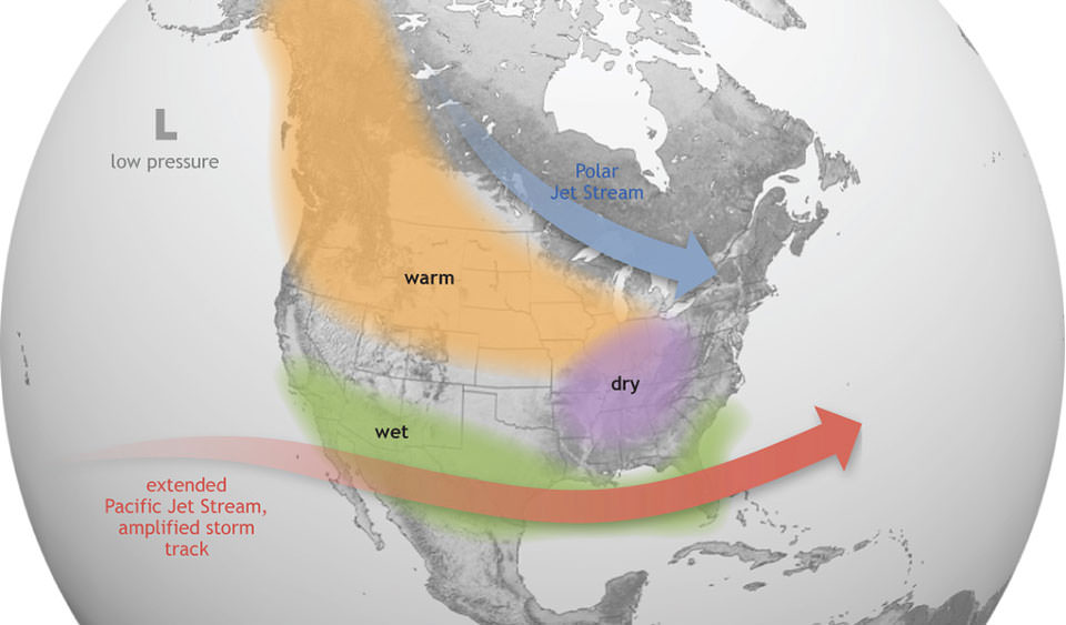
Thus, El Niño winters are *usually* warmer and drier in the Northwest, and colder and wetter in California and the Southwest as they essentially “steal” our winter rains and mountain snow.
Technically, water temperatures just being 0.5 degrees Celsius (about 0.9 F) above the climate average for three consecutive months in an area just off South America are enough to be counted as El Niño.
(This process will reverse then at the other end of the 3-7 year cycle where the easterly trade winds increase, cooling waters off South America even more through a more robust upwelling process. This is “La Niña” and usually super charges the jet stream into the Northwest.)
But this El Niño/La Niña cycle is more like a tidal chart — the peaks and valleys are somewhat predictable, but some peaks/valleys become larger than others. A high tide might be enhanced by spring tides and be much higher than usual (like a Strong El Niño) while neap tides bring super low tides (like a strong La Niña).
WHAT’S THE SUPER EL NIÑO “SCRIPT” FOR SEATTLE AREA?
So with the super-est of super El Niños looming this year, can we look to the past to see what might be in store this time around? Did the “warm and dry” winter El Niño script hold up? Warm: Yes. Dry? Not so much…
There have been three other very strong El Nino’s registered since 1950. Let’s see what happened then…
No. 3 1982-1983 winter. That El Niño reached +2.23 degrees C above average (remember — +0.5 is all that is needed to be an El Niño)
- No lowland snow — actually one of the few winters to not even to record a fraction of snow or even flurries at Sea-Tac.
- Top 15 warmest autumn+winters on record (Top 10 just winter)
- Lowland rainfall was actually a bit above average
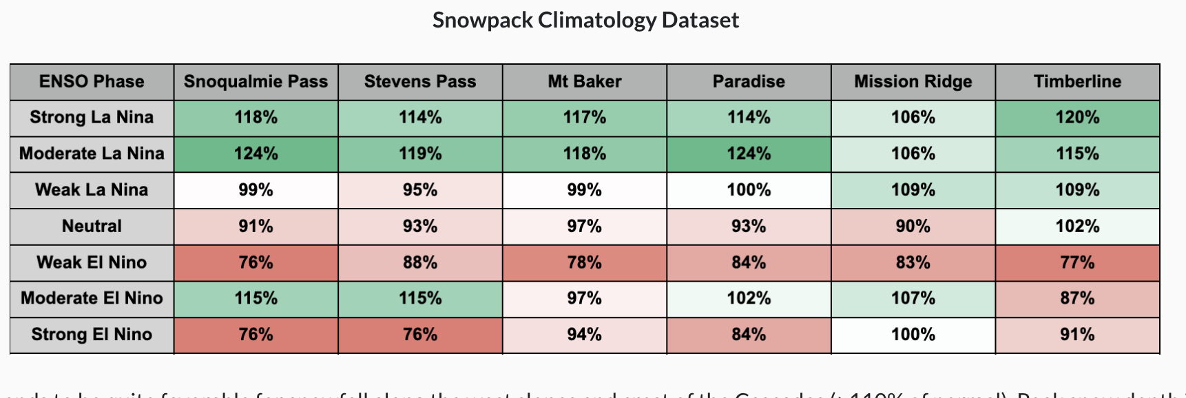
- Mountain snowfall: About 85% of average
No. 2: 1997-1998 winter. That El Niño reached +2.40 degrees C above average
- No noteworthy lowland snow in Seattle
- Above average temps for fall and winter
- About average overall precipitation but no flooding events reported
- Mountain snowfall about 90% of average.
No. 1: 2015-2016 winter. That El Niño was +2.75 C above average but also came on the heels of the “Blob” winter of 2014-15 that saw highly anomalous warming of waters just off the Northwestern coast (not El Niño related). But the combination of the two winters was a lot:
- No lowland snow for two consecutive winters in Seattle (2014-15 Blob winter and 2015-16 Super El Niño winter)
- Very warm winters back to back— 2015-16 El Niño stands as current 5th warmest winter on record. (Blob year before is No. 1)
- This greatest Super El Niño (so far) was the *wettest* winter on record in Seattle at 24.63″ between Dec. 1 and Feb. 28, including 18 days >0.50” inches in Seattle — also a record.
- Also, the city had 66 days of measurable rain in the winter out of 92 possible days from Dec. 1 to Feb. 28.
- Despite record rain: Mountains only 85% of snowfall (many of the moisture events were warm atmospheric rivers with high snow levels)
Notes about the data:
* While those Super El Niño aggregate snowfall numbers don’t look too daunting, just being a bit below normal, the snow depth numbers were worse because of frequent warming events to eat away at any recent snows.
* In the 1997-98 El Niño year, California got PUMMELED this winter with storms and it had an effect up here. Storms were SO geographically large going into California that the Northwest got rain from the northern edges of the storms, keeping us from winter drought.
* The 2015-16 El Niño was expected to be just as wet in California but the El Niño shifted its peak warmth off South American farther west, adjusting the angle on the jet stream to aim more at the Northwest, keeping us very wet instead.
* So far, the indications are leaning more toward a 1997-98 setup for El Niño warmth location closer to South America than the 2015-16 setup.
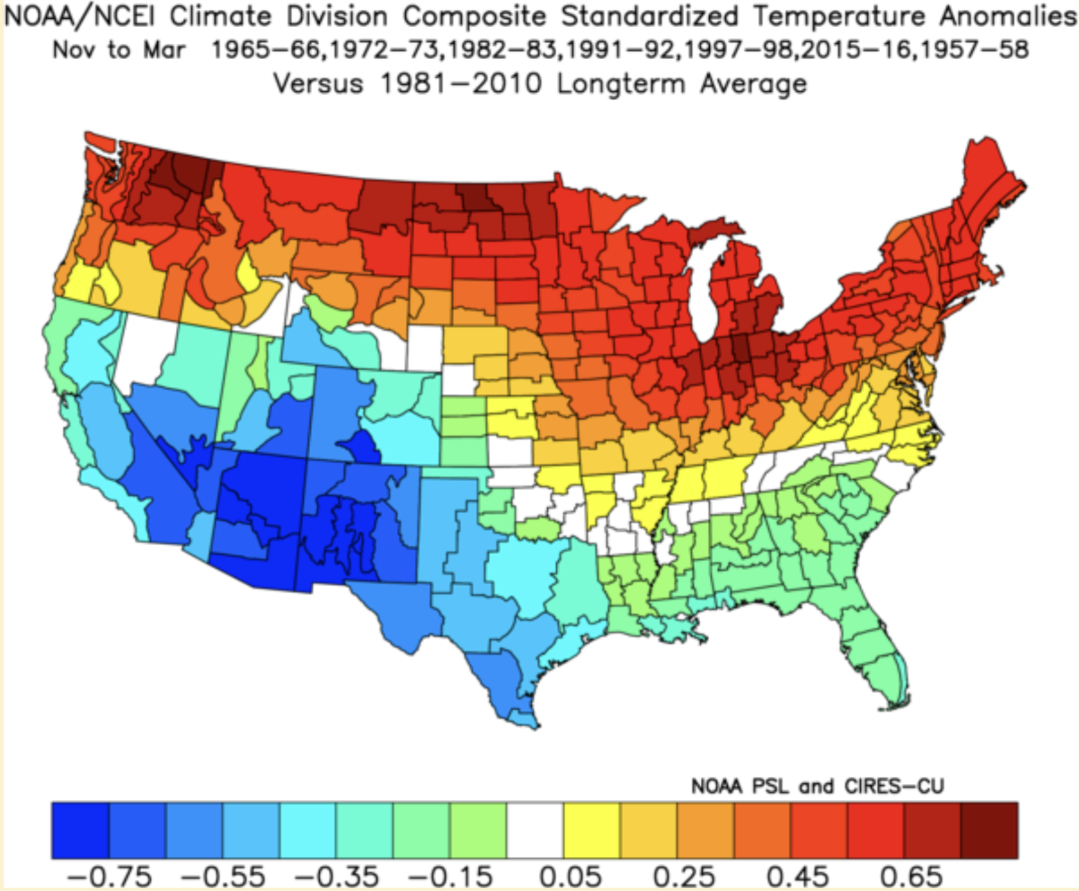
Thus it makes sense with this “script” from past strong El Niños that this is the general outlook you’ve probably been hearing for this winter: Much warmer than average temperatures, with little if any expectations of lowland snow.
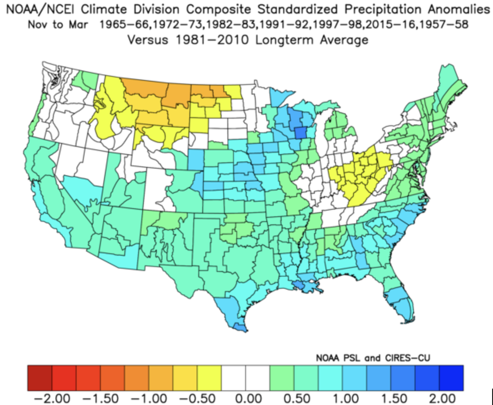
Rainfall is tougher to nail down — Weak to moderate El Niño’s tend to be dry but stronger ones seem somewhat wetter.
Mountain snowfall trends below average but not catastrophically so, though mountain snowpack tends to fare worse with more frequent warming.
ARE WE “COOKED”? GOBBLE UP THAT SCRIPT AND THROW IT AWAY?
Some forecasts have El Niño pushing at +3 or even +3.5 degrees C above average. Some of the higher outliers are even going well over +4. So we’re going literally into uncharted territory.
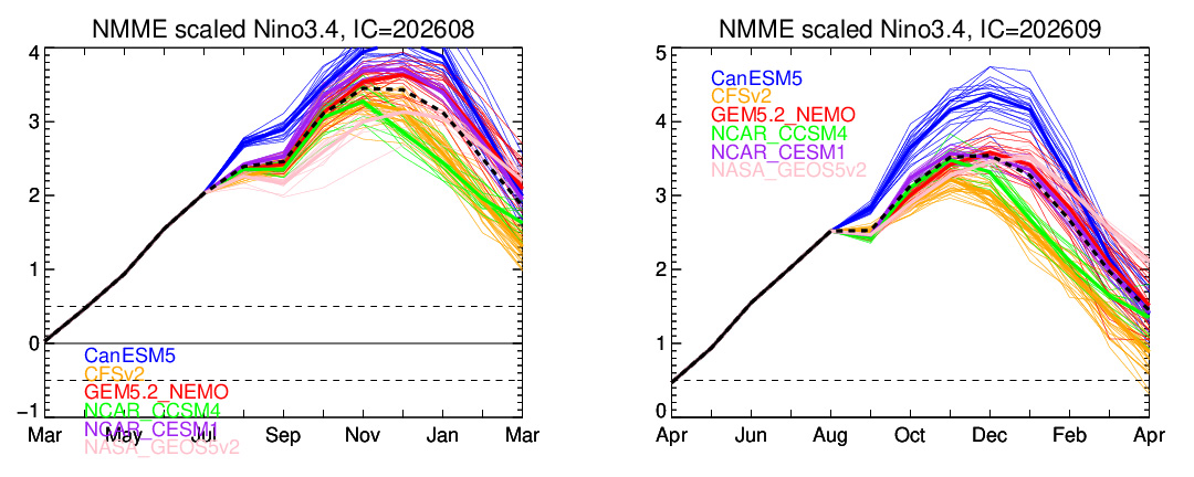
Could it be so strong it tips other balances that we’ve not experienced before?
The best metaphor I can think of is… cooking a turkey in the oven.
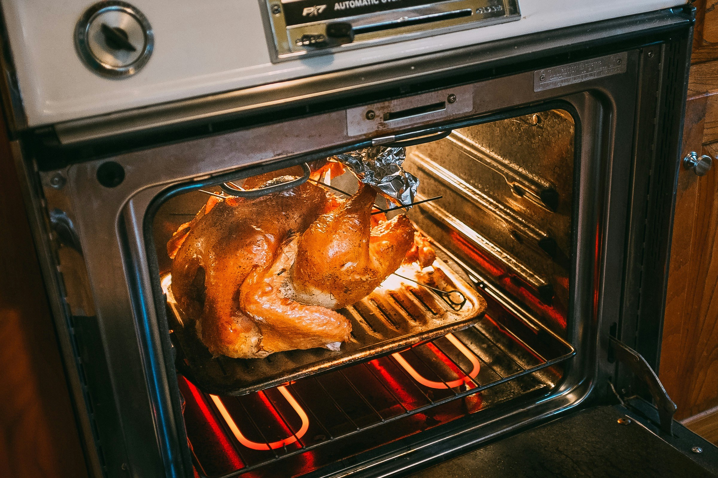
We know the optimal temperature setting for cooking a turkey to where it comes out as desired.
We also know that if the oven is set at too high of a temperature, the turkey will turn out charred and tough — unfortunate, with severe impacts on your dinner plans, but also predictable with impacts that were not unexpected.
Now your dinner has definitely gone OFF SCRIPT! Your kitchen is soon covered in water (rain?) or fire extinguisher dust (snow?) and that CERTAINLY wasn’t part of your expected dinner forecast or any previously predicted outcome.
(Note: This is *totally* not me drafting a metaphor off of a past Thanksgiving experience. Nope, definitely not…)
That’s not to say this Super El Niño is literally going to burn the Northwest down (Metaphor! Not Literal!) but I just think any winter outlooks are going to be tenuous, because we don’t have any real “scripts” to base what an El Niño of this size may entail.
I think this winter will probably end up warmer than average just because that’s a strong signal, but I’d also expect the unexpected.
MORE TO EXPLORE:
- Watch: Towering ‘anvil’ cloud stretches dozens of miles… and spans two countries!
- What are some scenarios a historic ‘Super El Nino’ could present for the Pacific Northwest and California?
- Strong thunderstorms bring rare ‘shelf clouds’ to Seattle area