Thick smoke to hang around Seattle area through at least Wednesday…then a break?
 Scott Sistek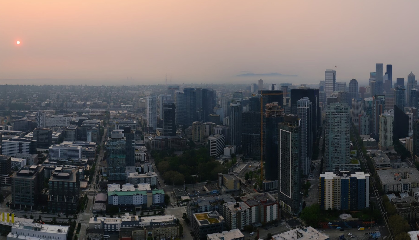
Wildfire smoke sits over Seattle Tuesday morning Aug. 4. (Photo: Space Needle Web Camera)
Tuesday is Day One of our three-day bout with wildfire smoke across Western Washington.
And while hot and smoky is an apt general description of the weather through Thursday, the latest high-resolution smoke forecast models suggest our thermal trough driving the east wind that’s pushing the smoke here may not be as strong as earlier advertised. And that means there may be at least *some* morsels of time in *some* places to at least find *somewhat* cleaner air near the surface.
For a brief recap of the overall situation, high pressure is in charge with a weak thermal trough hugging the coast that has mostly shut off our clean and cooling ocean breezes and instead flipped the general air flow from the east/northeast, pumping in all that smoke from B.C. and Eastern Washington.
Overall, there is no real hope for the next day or so for clearing out the smoke from the upper atmosphere — the smoke models show just about all of Washington and Oregon covered in thick smoke through at least Wednesday. (Remember, these forecast models can only forecast out 48 hours.) So this brown/orange haze is here to stay through then, no matter where you are.
But it’s the ground smoke where the air quality and respiratory concerns come in, and this has been a bit more variable so far, depending on your location and proximity to the smoke.
WHERE HAS IT BEEN BAD ON TUESDAY?
The worst ground smoke in Western Washington through mid Tuesday afternoon has been on the Eastside and along the Cascade foothills. The air quality in Central Washington has been unhealthy to flat out hazardous, pushing well beyond safe limits.
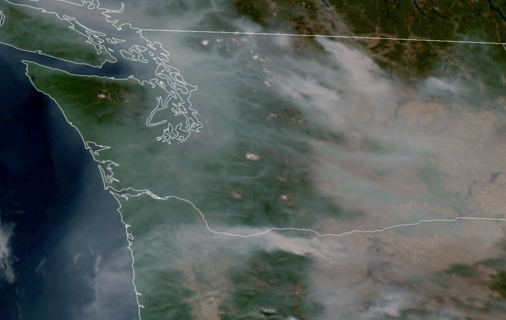
(“Hazardous” air quality begins at 300 on the AQI scale which tops out on the charts at 500, but Wenatchee and Leavenworth were pushing *1500*!!!! Tuesday afternoon). With the east winds revving up, that smoke is getting blown west through and over the passes into the western Cascade foothills and then spreading west across the Puget Sound area.
Stevens Pass corridor has been really bad with Index into the “very unhealthy” range with widespread “unhealthy” readings creeping faster west (Both North Bend and Fall City were pushing 200 AQI).
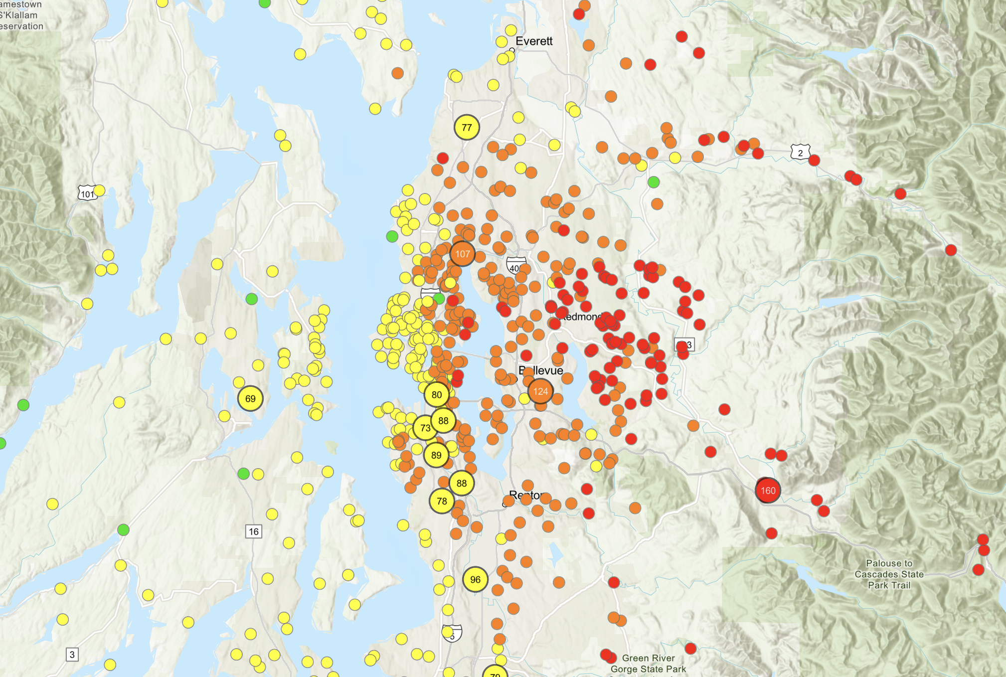
MORE: Get the latest Air Quality Observations
The air quality was steadily improving as you headed west toward Puget Sound but slowly getting worse as some of that Eastside air moves west. Areas near Puget Sound were in the moderate category but the North Sound and Snohomish County east of I-5 were turning into “Unhealthy for Sensitive Groups”
Whatcom County was getting its own low level smoke as it poured in from Canada’s Fraser River Valley. But areas west of Puget Sound were hanging in there for the low levels, despite the haze aloft.
WHAT HAPPENS TUESDAY NIGHT?
The models indicate the air quality will get worse across the Puget Sound area into this evening and that smoke keeps moving east, but then may actually get an evening seabreeze that could at least improve conditions a little near the waters of Puget Sound (though still very hazy with thick smoke aloft).
Areas along the coast and Strait of Juan de Fuca may also luck out a bit. However, sea breezes tend to fade overnight, and smoke aloft tends to then settle down so air quality may degrade again overnight into the dawn hours.
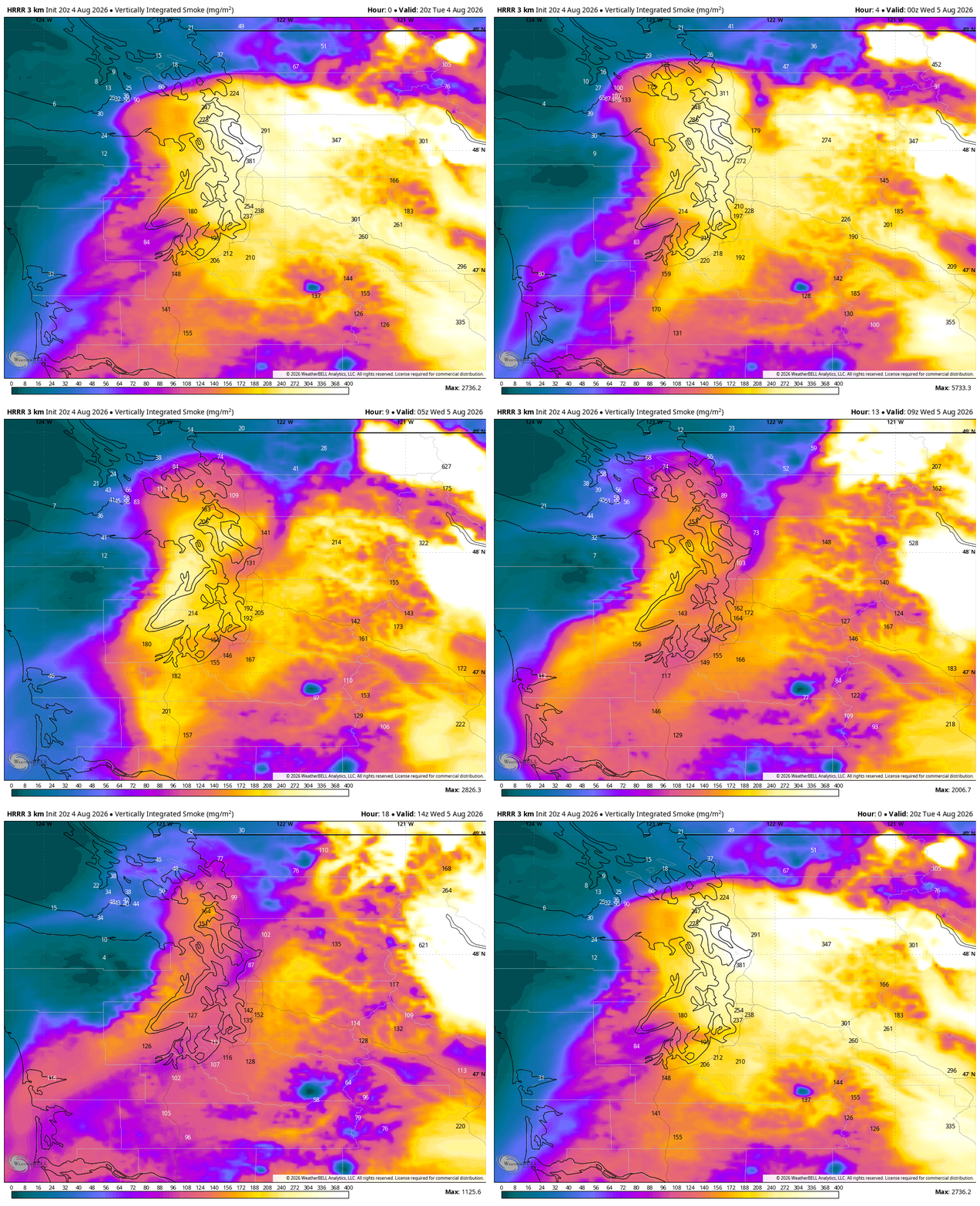
Those of you farther inland away from the water and closer to the Cascade foothills and in southwestern Washington, expect a very smoky Tuesday night with continued poor air quality that may get worse in the overnight/dawn hours.
WHAT HAPPENS WEDNESDAY?
Wednesday will be similar to today with plenty of thick, hazy smoke aloft across much of Western Washington, save maybe for the coast.
For ground smoke, the day will likely start very smoky and perhaps worse than Tuesday. But the latest high-resolution models are offering some more optimistic forecasts at least near the waters of Puget Sound — including Seattle and the Puget Sound I-5 corridor — where localized afternoon and evening sea breezes may ventilate some of the smoke and keep air quality a little more manageable.
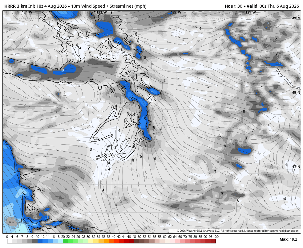
However, it still looks pretty miserable on the far Eastside and closer to the Cascade foothills. Central and Eastern Washington will remain horrible.
Also still very hot though, with highs in the mid 80s at least around the Puget Sound area (typical weather pattern would say low 90s but we lose some heat due to the sun blotting.) The National Weather Service has issued a Heat Advisory for nearly all of Western Washington, including the Seattle and Puget Sound area.
WHAT HAPPENS THURSDAY?
Maybe — Maaaaaaaybe — some early improvements. The latest models I see are hinting that with a weaker thermal trough, that we could get a little more westerly wind on Thursday — or at least a bit stronger of a localized sea breeze that could keep some of the Puget Sound Metro area air cleaner than it looked for this time yesterday. It could also shut off the smoke-importing engine from the east.
Confidence is low in that scenario so far, but the trend is hopeful. So call Thursday a wild card right now. Expect the smoky worst but know there’s some hope out there.
Still hot again on par with Wednesday’s mid-upper 80s. Heat Advisory remains in effect.
WHAT HAPPENS FRIDAY?
If the thermal trough and west wind haven’t arrived by Thursday, they should be here by Thursday night and that should start to at least clean out and cool off Western Washington.
Eventually, those west winds will jump over the Cascades and push away that smoke damming up against the eastern Cascade foothills and give some relief to places like Wenatchee and Leavenworth and Cle Elum.
Of course, that will just blow the smoke to the east and back across far Eastern Washington and out into the Inland Northwest.
WHAT ABOUT EASTERN WASHINGTON FIRE DANGER?
It will be hot and very dry with low relative humidity through the week, but the winds should remain calm. Overall, that still does bring some high fire danger in that fires remain very easy to start, but with relatively calm winds, we shouldn’t have the risk of rapid spread.
WHAT HAPPENS THIS WEEKEND?
It looks like good news for Western Washington as a very weak area of low pressure slides through to our north. This one looks too weak to bring any rain, but it would be enough to energize our westerly flow and bring back cleaner, ocean breezes and give us a break from the smoke for a bit. It will also keep temperatures in the 70s or low 80s.
On the other hand, this may increase fire dangers in Eastern Washington as those winds eventually make it over there, but so far peak gusts look to be about 20-30 mph as opposed to 40-50 mph from last Saturday.
ARE WE THEN DONE WITH THE SMOKE?
Unfortunately, no. Sadly, smoke will likely be a looming hazard for the next several weeks.
Western Washington and Western Oregon are indeed far better off than their east-of-the-Cascades counterparts as we’ll still get frequent access to cleaner, westerly winds that Eastern Washington won’t, giving us some days of a break from smoke.
But any time we get a wind shift away from the west, smoke will likely return. There are already some signals in the long range models that this could happen again sometime next week though confidence remains low as the consistency in the extended forecast is currently quite low.
But whatever tips or tricks you find to manage through this week, keep them handy. 🙁
MORE TO READ:
- Seattle nearly had its hottest rainy day on record
- Here is how to find and read wildfire smoke forecast models for Seattle and the U.S.
- What does a “Particularly Dangerous Situation” Fire Weather Warning mean for Eastern Washington?