
A while back I posted a far long-range forecast map showing quite a bit of rain for Seattle and the Northwest at the end of September, with a “wish” that for once the long range model would be true and we could get a dousing rain to make a dent in our summertime drought and help get these pesky wildfires out.
Wish… granted? (!)
… (what, no asterisk even?)
The timing slid back a day or two, but it does appear we are going to get our first like “real” rainy pattern of autumn next week. It’s even going to be kind and wait until after the weekend is over to turn on the hose so you can get in another weekend of pleasant weather for outdoor plans before October begins.
The weather pattern features a one-two punch with the first a quick jab; the second more of an elongated hug.
The quick jab comes as front sweeps through late Sunday through Monday. Clouds will be increasing Sunday but looks like the rain will hold off in the Puget Sound area until Sunday night.
Monday will feature rain at times with highs in the 60s. The second “hug” comes right on the heels Tuesday as a much larger (geographically) system heads our way. That front will come through on Tuesday into Wednesday and that looks pretty wet.
The end of the week depends on where the storm’s low pressure center goes — some models bring it our way and keep us with frequent showers through Friday; others send that part of the system south and we dry out a bit Thursday.
Before you think “uh oh, low pressure center heading our way — does this mean wind?”, not really. It’s not a very potent low and it’s forecast to be weakening on approach, it’s just rather broad with a large scattered shower field. No real impacts expected, just rainy at times. See, still no asterisk even!
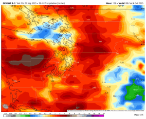
How much rain? If you are #TeamRain, then you are on #TeamEuro, which is predicting widespread totals of 1.5-2 inches of rain total when added up through the entire week 😍. (Shout out to fellow #TeamEuros! And no! Don’t actually expect to find weather people on that hashtag! I suspect you’ll instead find people excited about European currency. But #TeamECMWF is hard to type…)
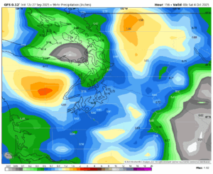
If you are #TeamSummer then you want #TeamAmerican (ALSO not a weather hash tag it seems, nor is Team AmericanModels 🤭…) or the more lame #TeamGFS. That forecast model… still has rain, but more like 0.50-0.75”. We’ll take what we can get.
Ironically, #TeamEuro is going drier and milder again the following week for those who want to WishCast sunnier weather back into existence! Come on over, #TeamGFS. We might even have cookies…