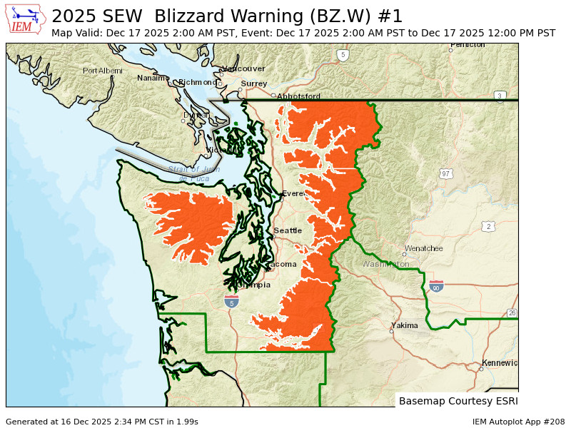
Blizzard Warning issued for mountains as potent storm rolls ashore with more rain, wind, flooding
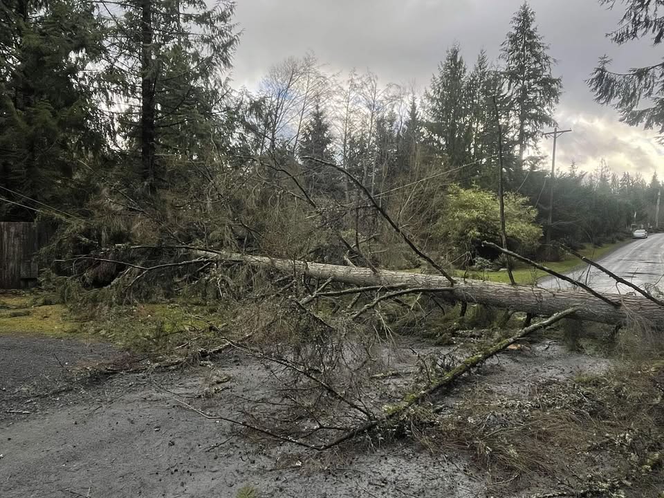
Tree falls in Snohomish on Dec. 15, 2025 .(Photo: Kristina Jensen)
Another day, another storm, but a very complex weather situation looms for this one Tuesday night that brings 3(!) different mechanism for strong winds — including one that caught the attention of national severe weather forecasters — along with heavy rains for renewed flooding and, making an inaugural appearance, heavy mountain snows.
That’s the TL;DR: Overnight windstorm and possible power outages Tuesday night into Wednesday morning (lots of “bumps in the night”), more flooding on some rivers, and treacherous mountain pass travel on Wednesday and beyond.
Let’s start with the wind since that has the most widespread impacts. To oversimplify it, the storm coming in overnight Tuesday into the predawn hours Wednesday will feature strong wind gusts of 45-50 mph across the Seattle/Puget Sound area, though gusts could reach up to 60 mph along the coast and along Hood Canal, south of Seattle and north of Everett.
That’s a small tick above many of the wind events we’ve had since this parade of atmospheric rivers began at the start of the month and with the relentless rains, the ground is beyond saturated and so it’s easier for trees to fall in lower wind speeds. So be ready for potential power outages overnight.
Wind may first be triggered as a powerful cold front attached to the storm sweeps through late Tuesday like 10 p.m or after. With strong wind shifts and unstable air along, this front could contain some pockets of lightning and damaging wind gusts along an accompanying “squall line”.
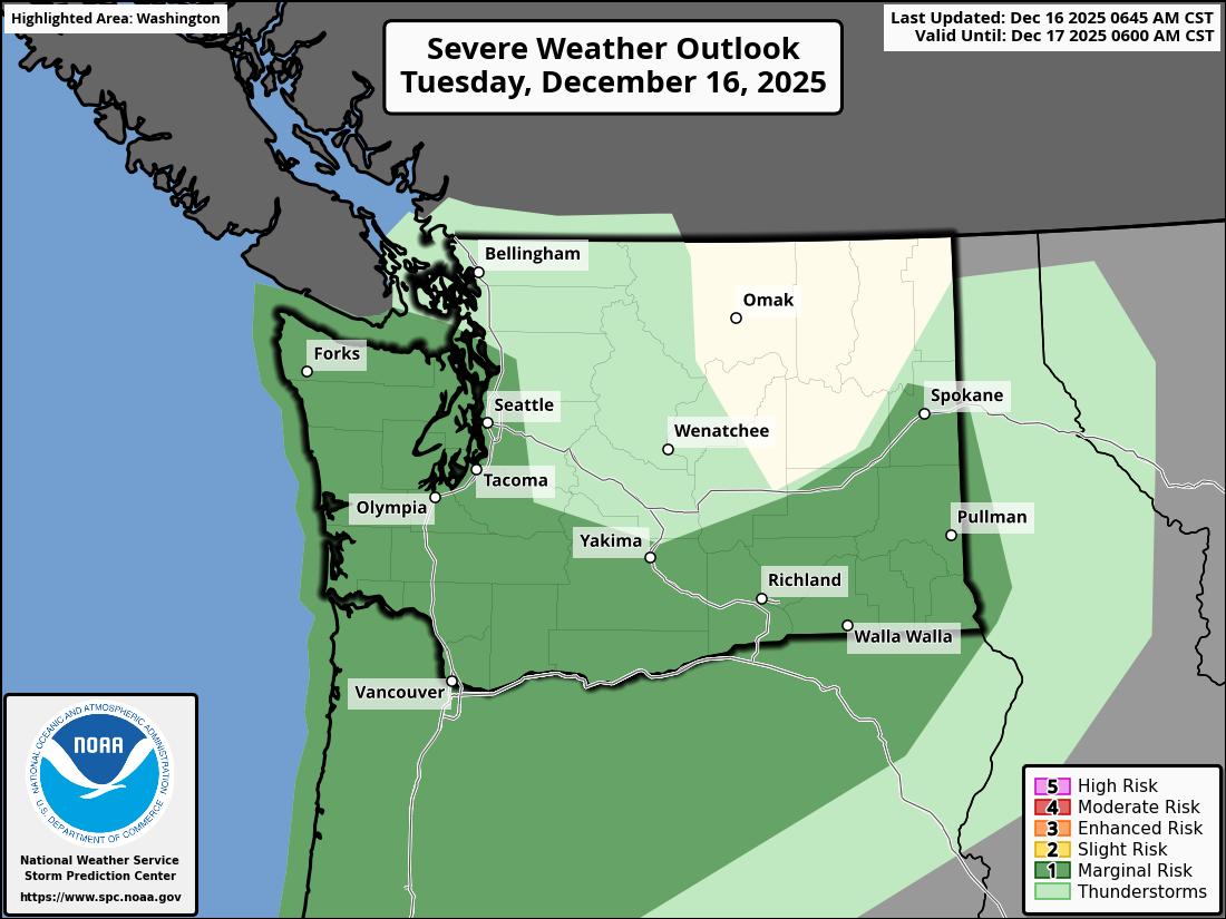
That has caught the attention of NOAA’s Storm Prediction Center, which has painted a Level 1 (out of 5) risk for severe weather across a wide swath of Washington and Oregon — including the Seattle/Puget Sound and Portland/Willamette Valley metro areas. This is exclusively for small risk of potential damaging wind gusts from convective storms — there is no risk of large hail or tornadoes.
Once that line passes, strong southerly winds will race to life across the region – this is more the “traditional” wind generator through something called a “lee side trough” could form just east of the Olympics — we had a bit of this Monday — that could enhance winds between Seattle and Olympia and along the Hood Canal.
Third, after a few hours of that and the storm continues moving east, we’ll get a surge of west wind chasing the storm down the Strait of Juan de Fuca as we get close to sunrise Wednesday for additional gusty winds up there.
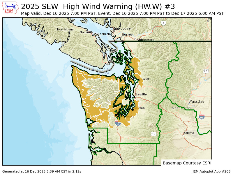
It’s a complex warning map, but there are High Wind Warnings (gusts 50-60 mph possible) in effect for essentially a doughnut around the Seattle Metro area — as in areas to the south, east, north and west of the core Puget Sound area.
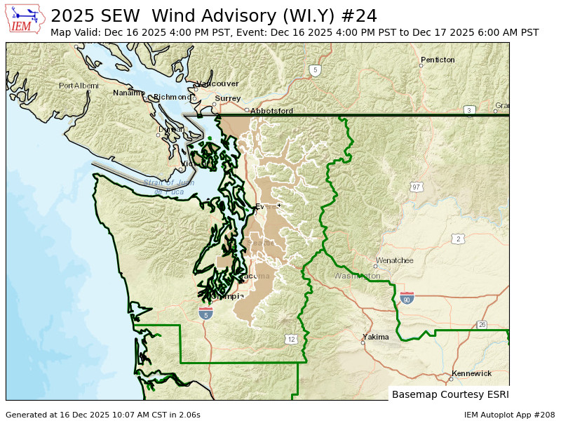
Meanwhile, a Wind Advisory (gusts to 50 mph) makes the “doughnut hole” of Seattle/Everett/Bellevue — but also far north like Whatcom County and the San Juans. I know. Just… look at the maps 😛
Just have an alternate way to set your alarm for the morning like a cell phone in case the power is out and maybe dig out that French press just in case if you need emergency coffee in the morning.
Winds will die down as daylight Wednesday gets going.
WHAT ABOUT FLOODING?
This storm does start with warm rains again that will put more pressure on rivers, especially the Skagit.
About 1-3 inches of rain will fall in the mountains later Tuesday into early Wednesday before snow levels crash down and finally stop allowing so much water to run off into the rivers.
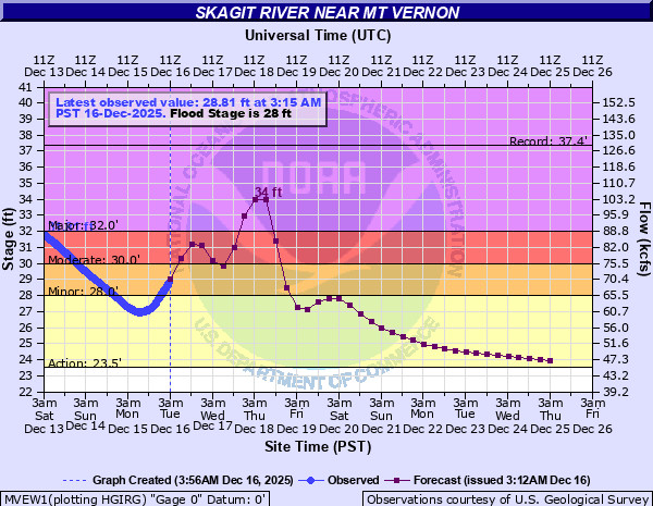
But before that happens, rivers will rise again. The Skagit is forecast to return to major flood stage near Concrete on Wednesday and by Mount Vernon on Thursday.

It won’t reach quite as high as over the weekend but still well into major flood stage.
The Snohomish, Snoqualmie, Skykomish are expected to return to “moderate” flood stage. Already we saw the levee issues along the Green River Monday night and there’s levee issues along the White River Tuesday.
It’s rain in the passes Tuesday. But the snow level will plummet to 2,000-2,500 feet by Wednesday morning, shutting off the flooding rains but now piling snow in the mountains… and the passes.
WILL WE EVER SEE THE SUN AGAIN?
The weather pattern remains very active through the end of the week with another storm due in Thursday and Friday. This is yet another atmospheric river with lots of moisture BUT this time it’s going to aim more toward Oregon, giving them more of the warm rains issues.
But up here, we’re on the “cool” side of the storm and instead we’ll see another round of heavy snows in the mountains with lowland rains and highs dropping into the 40s. It’s not good for our friends to the south but up here we will start reaping the benefits of starting to finally build a sustainable snowpack.
Extended forecast remains cool and wet into Christmas week with additional bouts of mountain snow.