How the epic ‘Storm King’ of 1880 buried Seattle in 64″ of snow as Columbus Day Storm-like winds hit Oregon
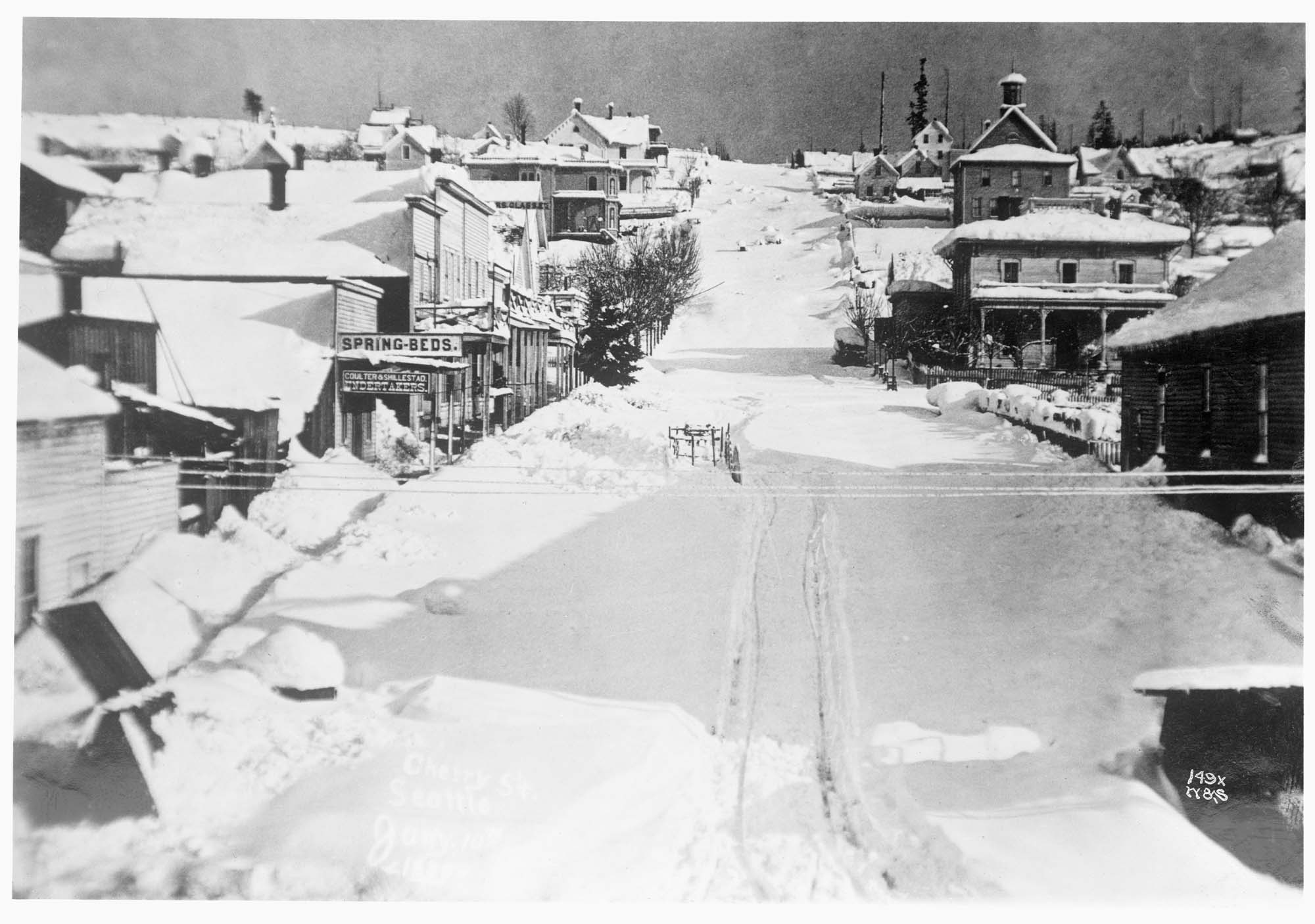
This photo was taken on January 10th, 1880 after the great snow. It shows the view up Cherry Street from First Avenue towards First Hill. (Photo: Peterson Brothers via Seattle Museum of History and Industry)
Ever wonder what would happen if you could create a storm that combined the immense power of the historic 1962 Columbus Day Storm with an intense arctic air mass?
Those who lived in the Pacific Northwest in the late 19th century didn’t have to imagine it; they lived through it!
This week marks the 146 year anniversary of the “Storm King”. And while the Columbus Day Storm frequently tops the list of greatest storms to strike the Northwest — aided by that it’s still within many lifetimes and was well observed at the time — the Storm King has a good argument to be ranked along side it.
And it all began with an ill-timed jinx by then-Washington Territory Governor Elisha Ferry.
It was just after New Year’s Day in 1880 — still nearly 10 years before Washington would earn statehood — when Ferry gave his “State of the Territory” report, according to research done by local historian Paul Dorpat, as published in Historylink.org.
Of course, as is Northwest tradition, the subject of the weather came up.
“When the statement is made that ice and snow are of rare occurrence and almost unknown in Western Washington, it appears to be so incredible to those residing many degrees south of this on the Atlantic Seaboard that it makes no permanent impression on the mind,” Ferry said, according to the Seattle Post-Intelligencer’s story on Jan. 4 that year.
The story didn’t age well, because by publish time, the temperature was already dropping below freezing, and a bitterly cold rain was just changing to snow.
It was the opening salvo of a series of intense storms coming off the Pacific Ocean that were about to slam into the Pacific Northwest, mixing with an arctic air mass falling out of B.C. that would bury Western Washington in feet of snow over eight days, while burying Western Oregon under miles and miles of felled trees.
Weather observations and data from the time period were few and far between. But noted local windstorm researcher Wolf Read used what he could find from those sporadic weather reports and clues from the media coverage in the aftermath to painstakingly reconstruct what likely happened to get such an incredible period of weather.
‘The prophecy and the actual measurements do not jibe’
Arctic air began sinking south into Western Washington on Jan. 5-6 as moisture moved in off the Pacific Ocean, starting a steady snowfall around Seattle. Luckily, those “Atlantic Seaboarders” wouldn’t have any way to know. It would be our little secret.
But it only got worse when a storm with a potent low pressure center likely tracked in just south of the mouth of the Columbia River, pulling in even more arctic air down into Western Washington while dumping what would have been several inches of rain into this frozen cauldron that instead, brought several inches of snow to Seattle and Western Washington.
With forecast models and satellites still decades into the future and not really much for a reliable network for weather observations yet, the city really had no idea what was coming.
“There’s no telling the depth of snow a few hours ahead,” an exasperated Seattle P-I reporter wrote on Jan. 8, according to Dorpat. “We tried it and wretchedly failed. The prophecy and the actual measurements do not jibe … We’ll be safe this time and suppose this morning’s snow depth at ten feet.”
Well, luckily it wasn’t *10* feet… but, it WAS pretty close to 5 feet by then, Dorpat said.
“We shall have to admit hereafter that snow does occasionally fall in this country,” the article lamented. “The average citizen walks nowadays as though he were drunk.”
It wasn’t even the worst part yet.
That would be next storm coming in on Jan. 9 that truly was the answer to “what if the Columbus Day Storm were a winter storm?”
OREGON: Winds likely neared triple digits in some locations.
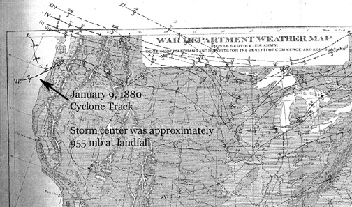
An intense low pressure center that appears to have rivaled any storm measured in the Pacific Northwest since, roared ashore right around Newport, Oregon, tracking to the northeast just north of Portland and Vancouver, with catastrophic hurricane-force winds on the south side of the storm and another massive snowstorm to the north on the storm’s colder but less windy side.
25% of Vancouver’s trees were felled and 100 buildings in Portland suffered damage, Read said.
The storm was so strong it even brought a hurricane-like storm surge into the coast.
Read found a letter from Newport, Oregon that noted: “We have just experienced one of the severest gales; nothing like it has occurred since the settlement of the bay. It was southeast, lasted about five hours, and was terrible in force . . . The tide rose seven feet higher than was ever known; nearly all the old wharves are taken away.”
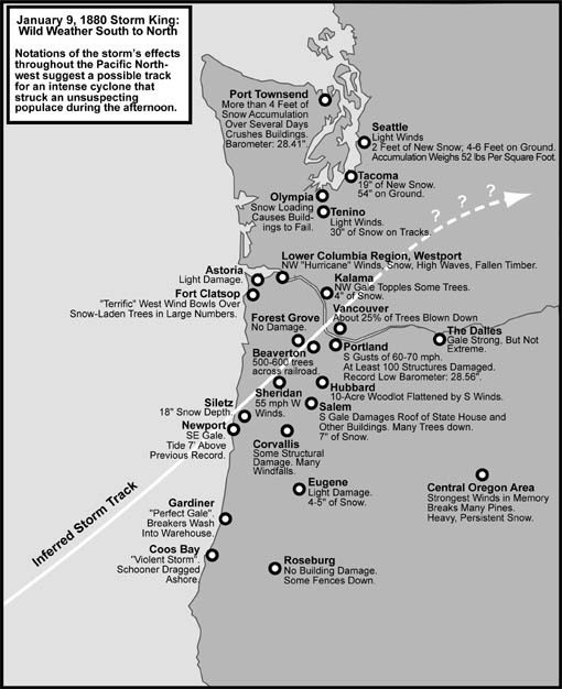
In Coos Bay, the Oregonian reported the three-masted schooner Emma Utter dragged anchor and was smashed ashore, Read said.
Read’s analysis said instantaneous wind gusts for the January 1880 windstorm could be estimated in the 85-90 mph range, “possibly 95-100 mph, for select regions between Salem and Portland that had reports of near total blowdown, including most of Clackamas County, eastern Washington County, and north of Portland in parts of Clarke County, Washington Territory.”
In the Willamette Valley, his research indicates 50 mph gusting to 75 as a good bet for wind speeds at most locations severely affected by the 1880 storm. “For the most severely flattened areas, such as just south and east of Portland’s downtown and in Clarke County, it is possible that brief wind gusts reached 80 to 90 mph,” Read said.
How strong was the storm? Two ships that were just off the Oregon coast managed to survive the storm’s onslaught, though heavily damaged, but were eventually able to record the atmospheric pressure.
Both reported a pressure of 955 millibars — about 28.20 inches of mercury. Read surmises the ships were on either side of the storm center meaning the actual central pressure could have been even lower. But those numbers are on par with a Category 3 hurricane and even a little deeper than the Columbus Day Storm.
The 1880 cyclone also appears to have produced the most extreme barometric trace in the weather record of Oregon, Read said. A barometer in Portland recorded a pressure surge as the storm came in from 28.56” (967 mb) to 29.18” (988 mb) in just 2.5 hours.
WASHINGTON: No wind, just more snow!
Meanwhile Seattle reported nary a breeze on the north side of the storm… but gobs and gobs more snow on top of the 2-4 feet that had already fallen.
Read said this new storm added an additional 2 feet to the region.
According to a train from Kalama that finally arrived days late on Jan. 11, the snow at Tacoma was 35 inches deep early Friday, and this figure had jumped to 54 inches by Monday afternoon.
Olympia reported severe damage to structures, and sheds and barns collapsed at Port Townsend, Read said.
In Seattle, Read reported that on the 8th, flakes accumulated at the rate of 1.5″ an hour with temperatures just above freezing, making for a heavy, wet blanket.
“The weight of the snow base had reached 52 pounds per square foot, causing roofs to fail,” Read wrote.
Telegraph lines between Seattle and Portland suffered widespread destruction, as were those around Port Townsend. With regional travel also paralyzed, news was slow to non-existent with the outside world.
It led to an amusing observation Read found in The Oregonian, especially for those reading this recap in 2026.
“The work of rebuilding the telegraph lines is necessarily slower as many hundreds of poles were thrown down, but it is expected that through communication will be opened by Wednesday,” the paper reported. “In the meantime the public has the opportunity of amusing itself by guessing at what the great outside world is doing, and may possibly find consolation that the tedious and annoying delay will matter but little a hundred years from now.”
Read noted the irony that almost exactly 100 years after that was written, Mt. St. Helens erupted; “an event captured in full color and broadcast on television for the entire country to see,” Read said.
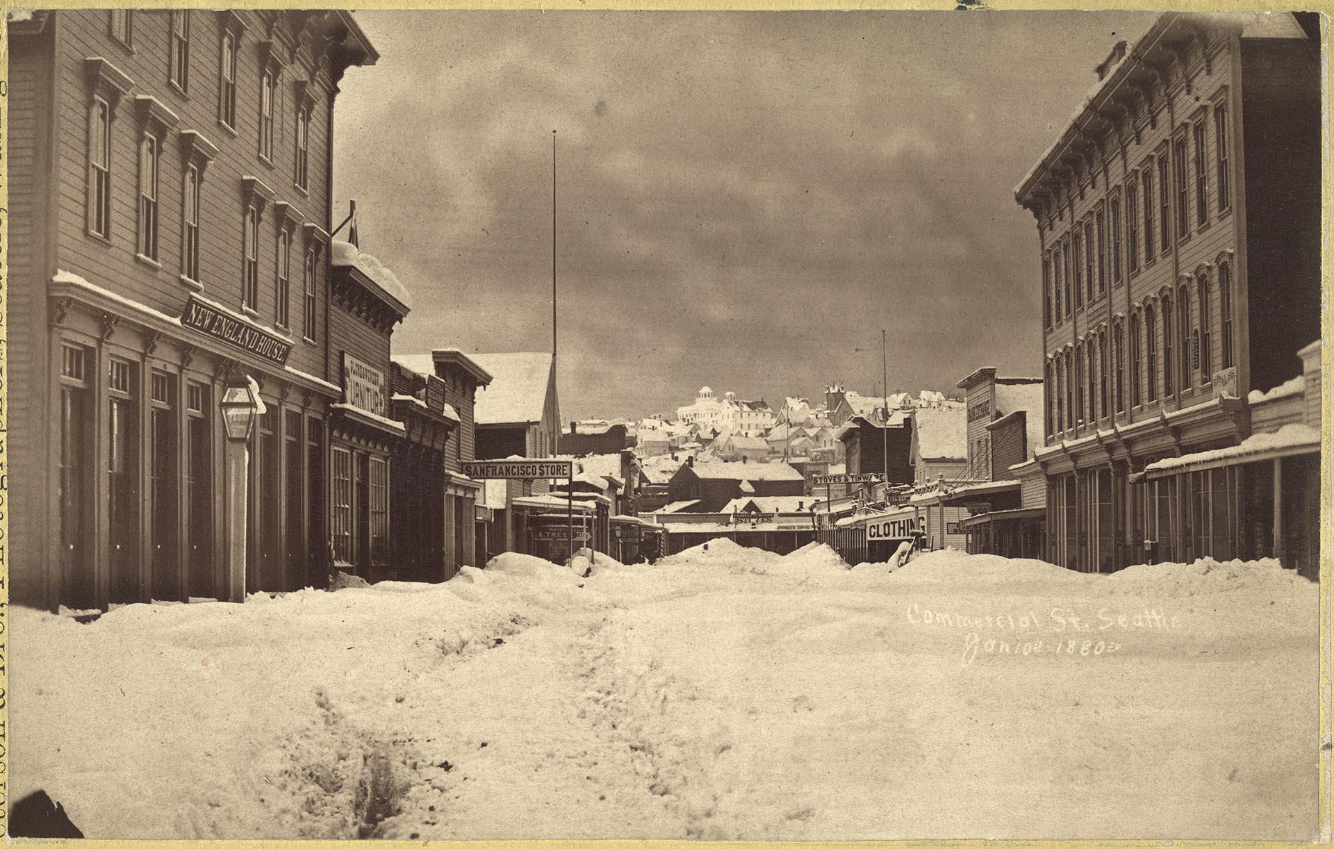
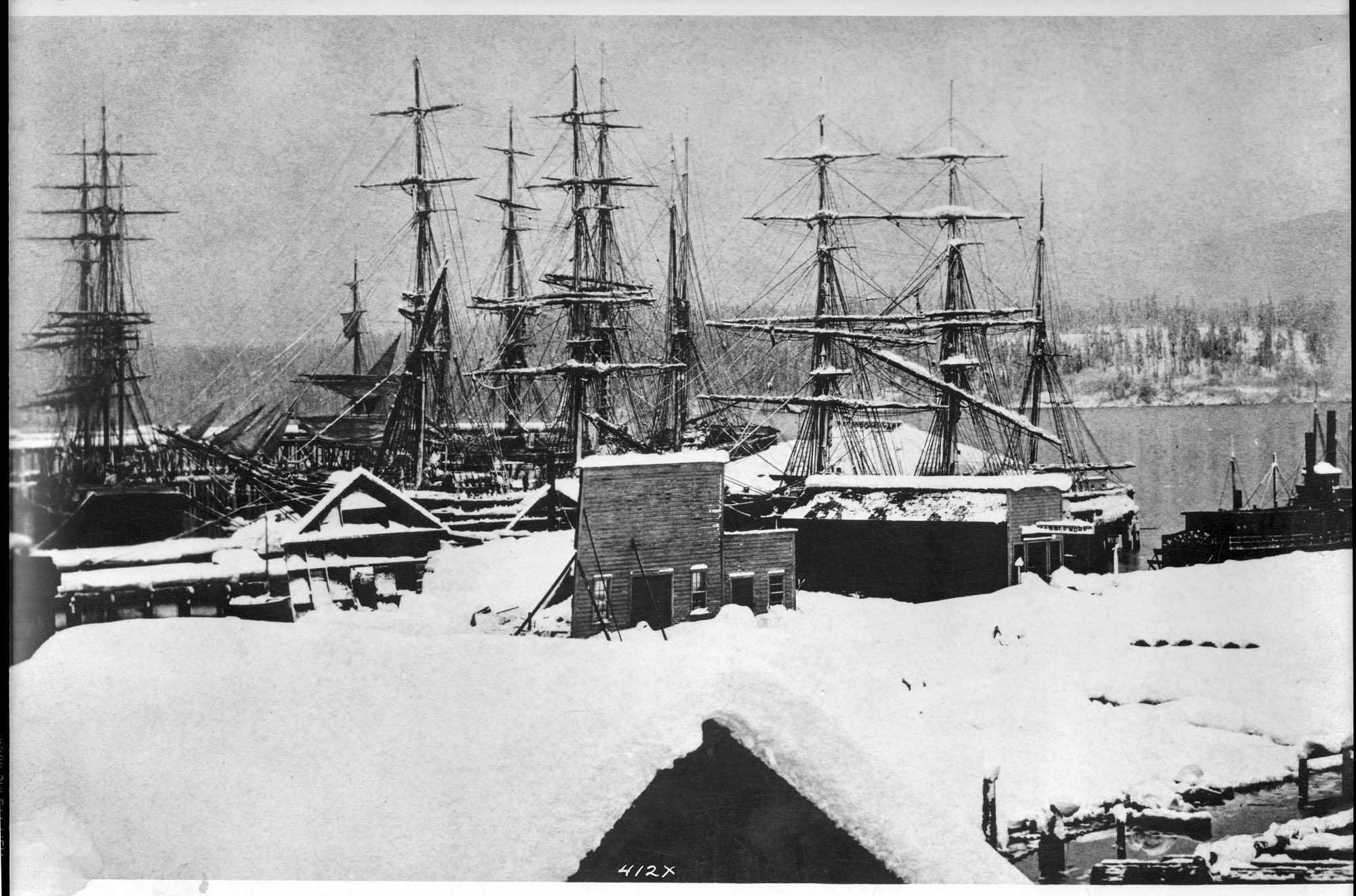
Snow would continue in the following days, making an eight day snowfall total of 64 inches of snow in Seattle.
It would stand — and still stands — as among the greatest snowstorms in Seattle history, probably only closely rivaled by the 21.5″ of one-day snow during the blizzard of Feb. 1916 and the month-long arctic outbreak of January 1950.
It likely led to Ferry to learn an important lesson:
Don’t taunt Mother Nature.
SCOTT! it amazing at what lengths you go through to capture all of the information AND PHOTOD for your blog!
We APPRECIATE you and look forward to your blog each day!
Ah Paul Dorpat! A living encyclopedia of Seattle, and addict of Gold bars! Great article, thanks Scott!
I wonder if deep low-pressure events like the Storm King and the Columbus Day storm are 100-year events. The effects are based on the timing of fall vs winter and the track of the low-pressure center.