Stormy Thanksgiving week brings threats of coastal flooding, strong winds to Western Washington
 Scott Sistek
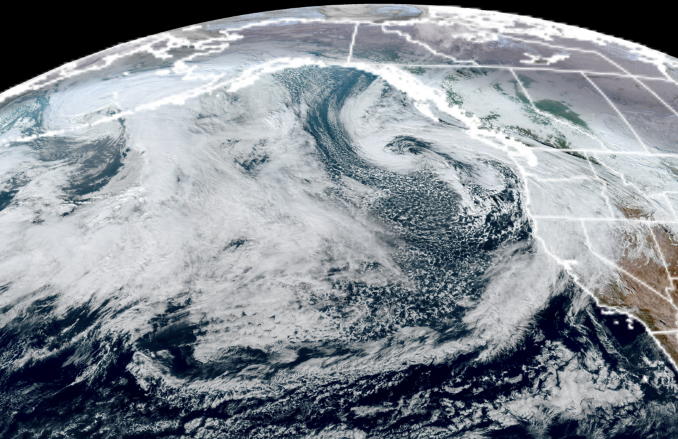
GOES-18 satellite image from Nov. 21, 2026 showing the first of many storms to impact the Pacific Northwest for Thanksgiving week. (NOAA / CIRA / RAAM-B)
Storm topics covered in this forecast:
* Multiple storms coming through the Northwest this Thanksgiving week
* Coastal/tidal flooding could be moderate to major issue along the coast and minor to moderate in inland waters with high surf and high astronomical king tides
* East winds may be strong in the Cascade foothills and passes on Wednesday.
* Wednesday travel will be very wet and blustery but no major wind/river flooding events seen in the Seattle I-5/405 corridor Puget Sound urban areas.
* How big is too big when it comes to having coffee in the car?
Most might be heading for the airport this week to catch a flight or packing the car for the drive to grandma’s house…
We’ve got a train to catch. The Storm Train, that is. It’s about to depart and we’ve got a reserved seat.
The weather pattern is advertising increasingly stronger storms lining up to roll through the Pacific Northwest just as we get into the busy Thanksgiving travel season. But the good news is that for *most* of the Seattle/Puget Sound urban metro areas, none of these storms are looking like they will be very impactful, aside from likely making for some rainy, blustery, messy, better-download-extra-podcast-and-get-the-50oz.-coffee-commutes or family trips.
(50 ounce coffees are a thing for others, right?)
(“What kind of industrial-sized cup holders are in your car, Scott?!?” 😮)
That said, we do have some impacts likely to parts of the wider region in potentially some moderate to even major coastal/tidal flooding (See at the bottom for a special section on that), some gusty to strong easterly winds though the Cascades passes and Eastside foothills, and maybe some mountain snow at times.
The “storm” this weekend is a gentle appetizer with just continued light showers Sunday with a few snow showers in the mountains as a weak low pressure center stalls off the coast as it fizzles. No biggie here.
We might see a few straggling showers on Monday along with some areas of fog as the leftover moisture is slow to clear, but generally it’ll feel like a dry day by November standards.
Then a large upper level trough sets up shop in the Gulf of Alaska, and this will be the engine that energizes and spins multiple strong low pressure centers around its base and pinwheels them toward the Northwest.
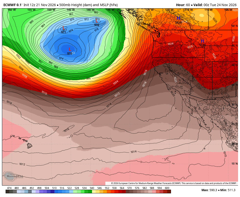
The storms will be deep and powerful, generating massive waves in the offshore Pacific once again. The satellite image is going to look 😮 all week.
The first of these storms is looming for Tuesday into pre-dawn Wednesday, then a second, stronger storm is timing for Wednesday afternoon travel peak (64 ounce coffee?!?) into Thanksgiving day, with a third storm taking aim for the back half of the holiday weekend — just in time for the return trip home.
That all might sound ominous, but much like the storms behaved in the first half of the month, the first two of these storm centers are expected to curl back to the north and stay far enough away from our region to spare us traditional November widespread wind events.
However, the storms will be close enough to swing strong cold fronts through the region for periods of moderate to heavy rain and gusty winds — especially on the coast and Northwest Interior — but not like, widespread windstorm-y winds and the Seattle metro area should stay well within reason.
TUESDAY’S STORM: SOME RAIN AND MOUNTAIN SNOW
The first Tuesday storm will bring rain starting around dawn with light to moderate rain lasting through the day into Tuesday night, with probably just wet snow/slush at Snoqualmie Pass but indeed some light to moderate snow in the higher passes during the period.
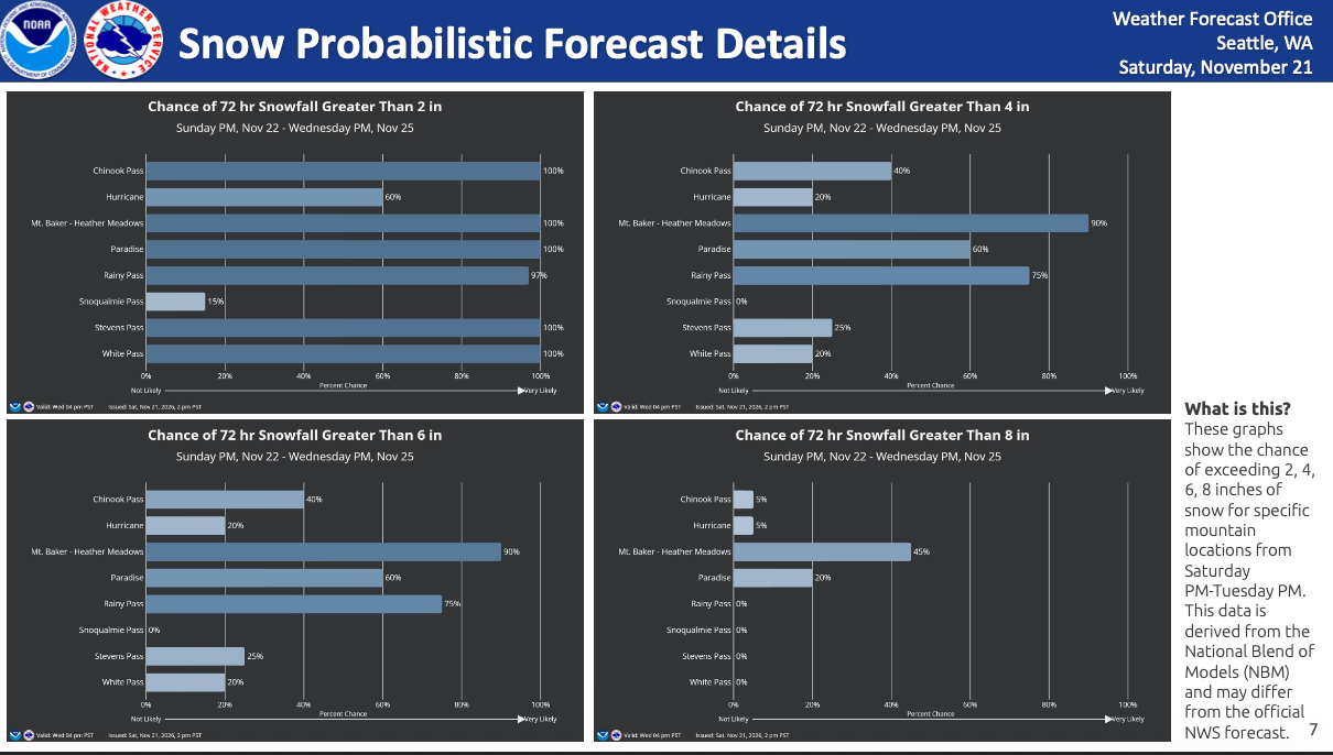
It’s stronger than this weekend’s storm but still not very impactful, though it will also kick off the extended threat of coastal flooding as surf begins to build and king tides begin to enhance our high tides.
WEDNESDAY/THURSDAY’S STORM: STRONG EAST WINDS(?), HEAVIER RAIN
There will be a very brief break in the rain Wednesday morning before the next, stronger storm arrives Wednesday afternoon and lasts into Thanksgiving with a renewed round of heavier rains and more in the way of mountain snow.
This storm will have a deep low pressure center that will stay well offshore, but will spend some time swirling due west of Washington as it heads north.
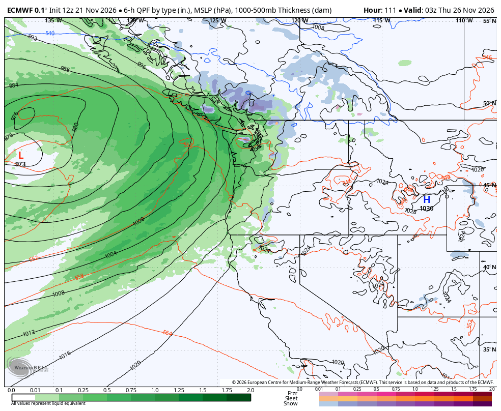
That position would create a perfect west-east alignment with the pressure gradient to push strong winds from eastern Washington through the mountain gaps and passes into the Cascade foothill communities like North Bend, Enumclaw, Gold Bar, Black Diamond, Monroe — etc. Veterans of a few winters here know those east winds well.
It’s a bit early yet to get a good projection on wind speeds, some earlier models had been advertising potential for 50+ mph gusts Wednesday.
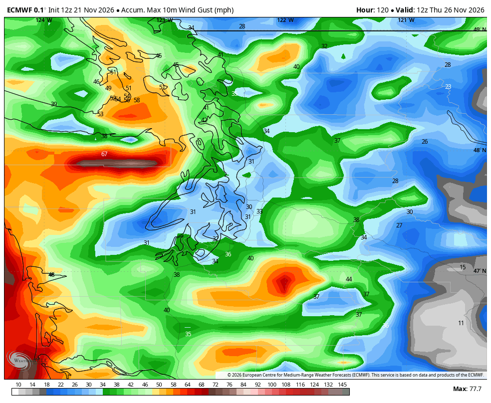
However, the later model runs are going a little weaker with the storm center offshore, which would ease back the winds. Also, it’s not super cold in Eastern Washington, which normally would enhance higher pressure there. Stay tuned there. It’d be windy on the coast too, but just blustery in the rest of the Puget Sound area and not impactful winds.
Snow levels look to stay 5,000 feet or higher so we may stay just rainy/windy in the passes.
Another storm looms for Saturday/Sunday — this one may have a storm center come in closer to the Northwest for a windier day across the region with more rain, but too early for specifics yet. (128-ounce coffees?!?!)
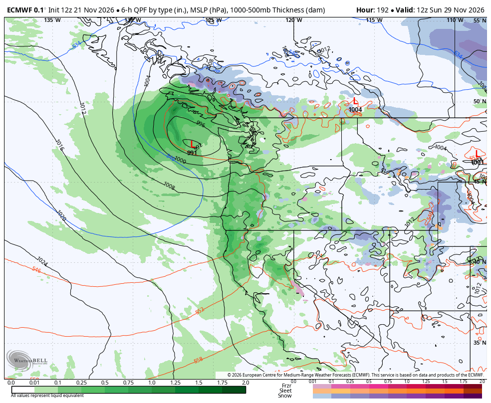
We’ll keep an eye on it!
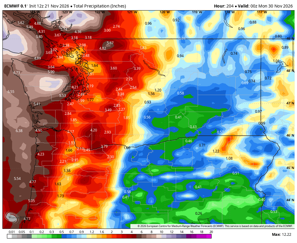
The good news is, river flooding does not look to be a concern, aside from maybe some minor flooding along the Skokomish.
THAT SUCKS: LOW PRESSURE TO COMBINE WITH SUPER MOON TO BRING COASTAL FLOODING THREATS
Unfortunately for those of you who live/work where tidal flooding is a possible threat, this week is shaping up to be — not a worst-case scenario, but a bad-case scenario that we were worried about with potential unlucky tandem of timing up strong storms with unfavorable planetary and lunar orbits that bring us a supermoon at the worst time.
(I giggle every time I type supermoon because when I worked at a previous job, the content management system would frequently auto correct it to “super moron”.)
Here’s what’s in play that’s making this week’s high tides daunting for coastal flooding:
1. We have multiple strong storms with deep low pressure centers bringing increasing large waves and dangerous surf to the coast.
2. The lower atmospheric pressure “tugs” on the surface of the water, raising sea levels a little higher than usual.
3. The full moon is Tuesday which already enhances high tides.
4. This full moon is coming right at the time the moon is also making its closest pass to Earth in its elliptical orbit (“Supermoon!”), enhancing tides more. (“King tides”)
5. The Earth is nearing its closest point to the sun on our own elliptical orbit around the star (closest point in January) so we get another extra gravity tug from the sun.
6. El Niño has brought warmer waters and added its own little bump to sea levels along the West Coast.
Put those all together and we have some very high tides coming up that with the enhanced waves and surf will make for moderate to major flooding on the coast starting with Monday’s high tide cycles.
The inland waters including Puget Sound and Salish Sea don’t have to worry about the ocean surf, but will have items 2 through 6 in play starting with Tuesday and Wednesday’s high tides making impactful tidal flooding likely along the waterfronts too.
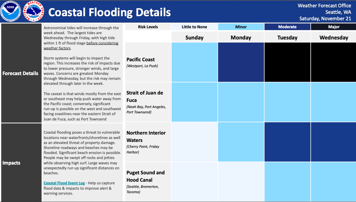
King tides start to fade by the end of the week. But it’ll remain stormy.
However, don’t look now but the period around Christmas week will present a renewed threat of enhanced tidal flooding as we have yet again another poorly timed supermoon and this time Earth will be even a little closer to the sun, so the high tide potential is even a little higher if we get another stormy stretch then.
Whew, that was a lot to read. Thanks for making it this far if you have.
(See, this is why they need 50 ounce coffees, right? ☕☕☕)