How Seattle’s rare August rain could make the wildfire situation worse in Eastern Washington
 Scott Sistek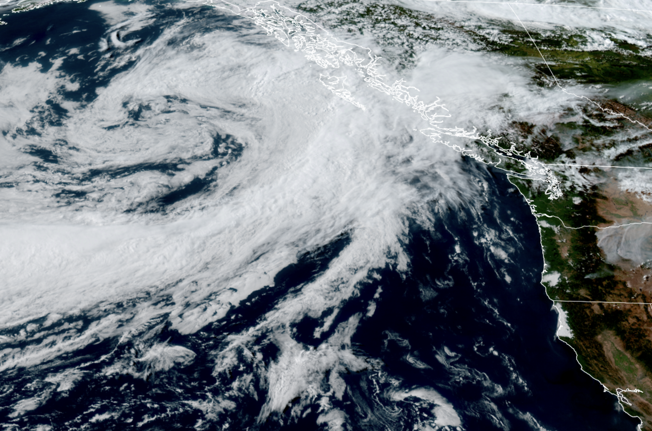
GOES 18 satellite image showing large low pressure center off the B.C. coast and its approaching cold front on July 29, 2026. (NOAA / CIRA / RAAM-B)
The weather is not only about to pull off a rare feat in the Pacific Northwest, but perhaps a counter-intuitive one as well.
All of Washington will feel a summery, warm sunny day on Friday — generally 80s on the west side of the Cascades; 90s on the east side.
Then comes the clouds and rare early August rain to the west side on Saturday.
Periods of rain are expected Saturday morning into midday and then a Puget Sound Convergence Zone is likely to keep showers going in Snohomish County into the night, with a few lingering showers possible Sunday morning, but generally a much drier day.
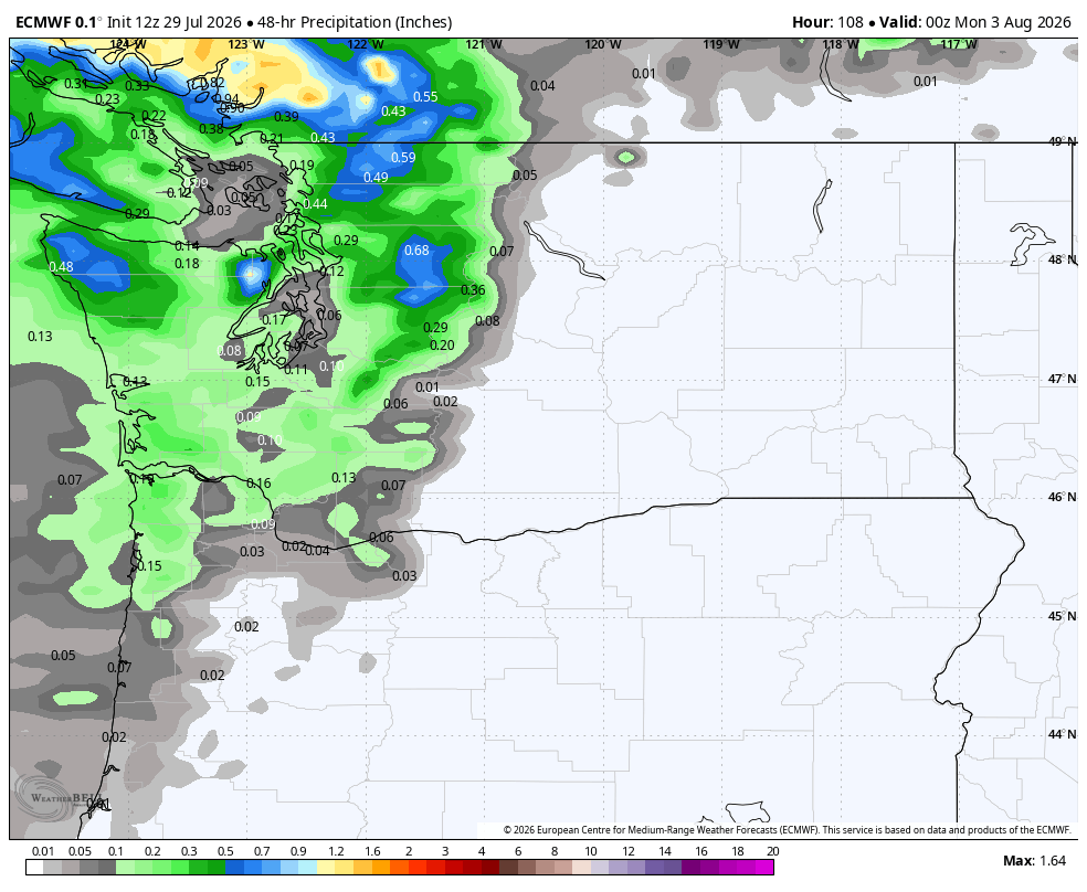
The coast and far North Sound may get a quarter inch or so of rain while Seattle and the Puget Sound area will likely get around a tenth of an inch. Not a lot, but generally welcome (except for that whole “it’s the big SeaFair weekend” thing…)
If you missed Tuesday’s post, it’ll likely be Seattle’s first measurable rain on Aug. 1 since 2008, and only second day of rain on August 1st since 1985.
MORE: Seattle could see one of its rarest weather feats this weekend: Rain
NWS: “CRITICAL TO EXTREME FIRE CONDITIONS POSSIBLE”
And yet, this will somehow make wildfire conditions *worse* in Eastern Washington?
Yes, because while they will miss out on the rain, which will essentially be blocked by the Cascades, they will crucially not miss out on the wind.
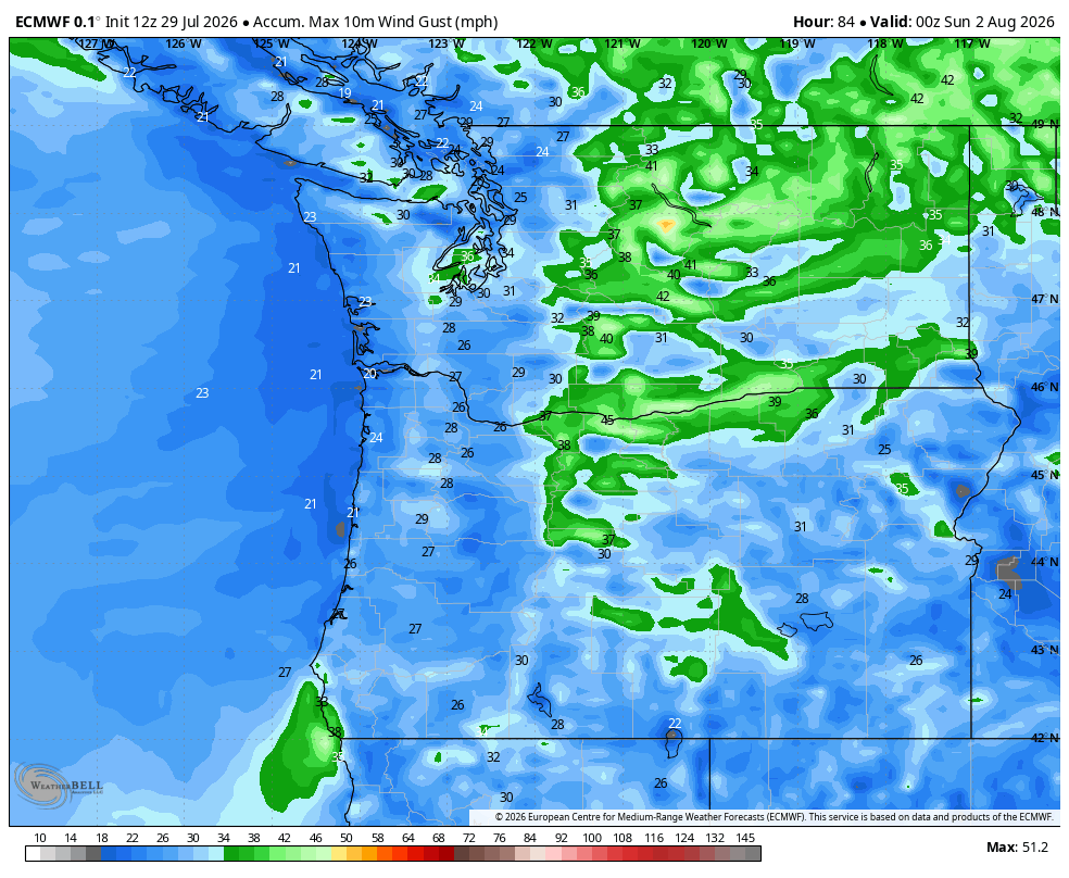
Eastern Washington frequently bakes in the summer as high pressure gets entrenched in the Inland Northwest, shutting off much in the way of air flow and allowing the hot summer sun and warming, sinking air to lower the humidity and push temperatures into the 90s (or 100s if the ridge is really strong and intense.)
But on days when the hot weather pattern breaks and the ridge gets “pushed” aside (in this case by the approaching low pressure center and its front), the weather pattern mimics a deflating balloon.
Cool, marine winds from western Washington rush over and through the Cascades to replace this departing dome of hot air. It’s refreshing in one sense for Eastern Washington because it will bring relief from the heat and temperature down into the 70s or so.
But it’s still dry air. And now it’s really windy. And those are two things you don’t want when dealing with wildfires.
As such, Fire Weather Watches now stretch across much of Eastern Washington Saturday (and into parts of Oregon, Idaho and Montana) for the double whammy of wind gusts of 30-50 mph and relative humidity levels of 15-25%.
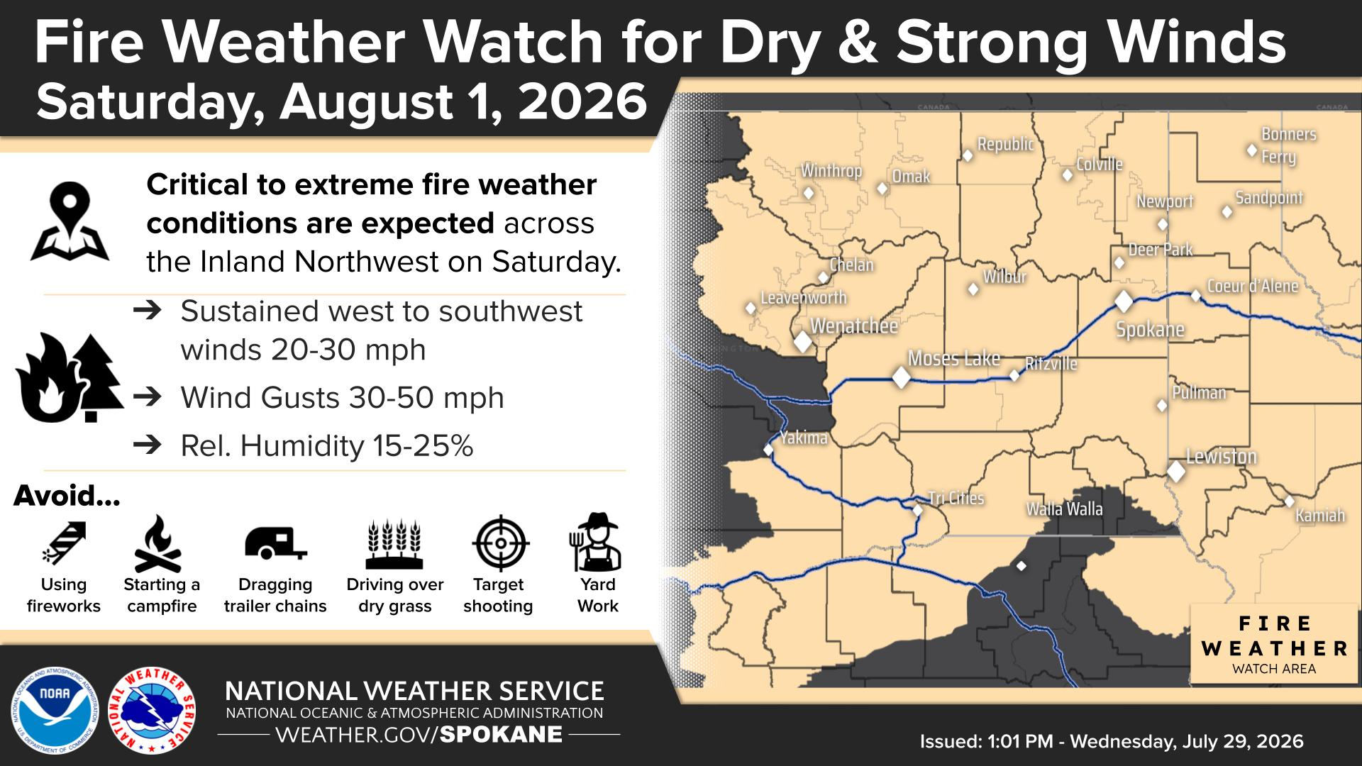
The National Weather Service says that is a recipe for “critical to extreme fire weather conditions” and that means erratic and dangerous behavior is possible on current — or new — wildfires, and that any new sparks could quickly become a racing, raging inferno.
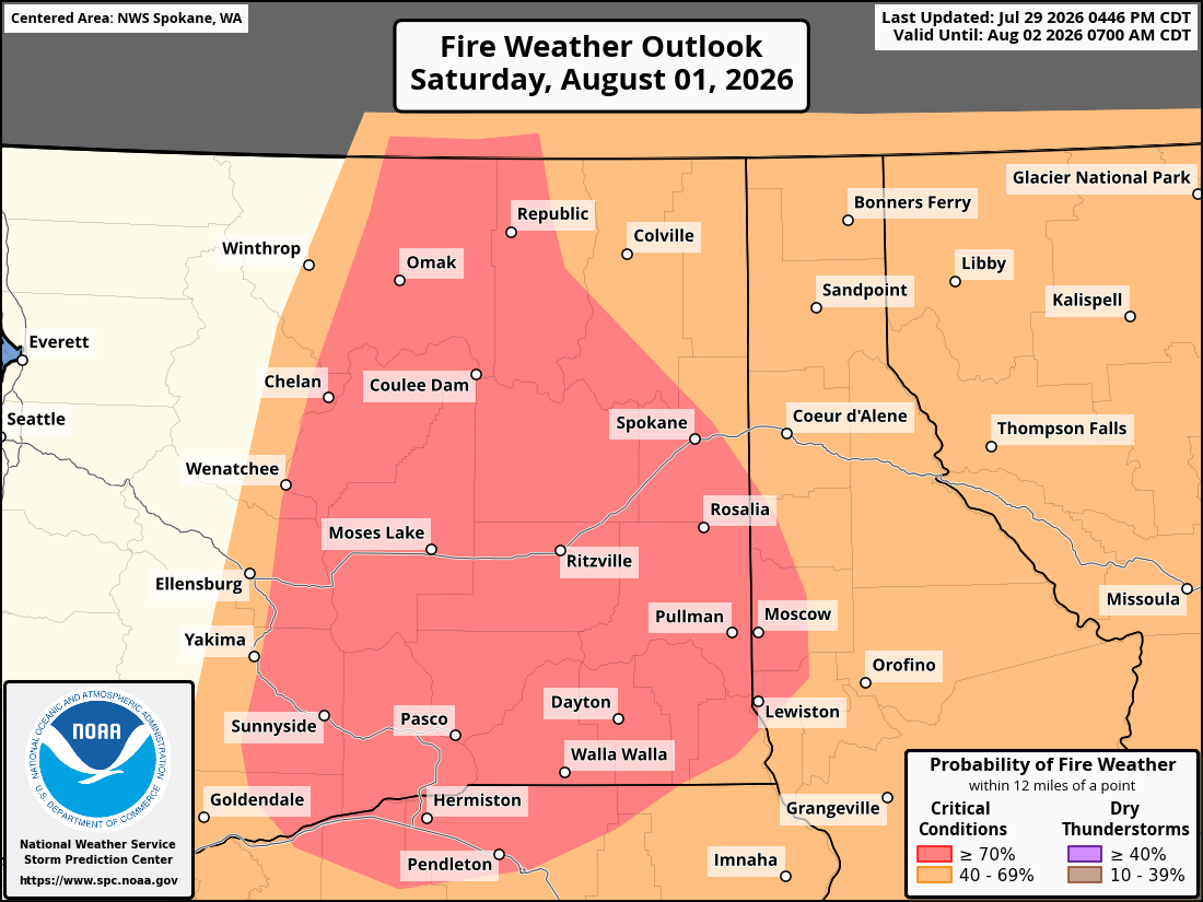
Evacuations may come sudden and urgently so if you are in that Fire Weather Watch area, you know the drill — keep keen tabs on the news.
To help prevent fires, the NWS asks those in the Watch area to avoid:
* Using fireworks
* Starting campfires
* Dragging trailer chains
* Driving over dry grass
* Target shooting
* Yard Work
The only silver lining is that temperatures will cool on Saturday making it easier on the firefighting crews, though the heat returns in short order.
They’ll take what they can get. It’s been a tough wildfire season already.
“We are witnessing an unprecedented and record-breaking wildfire season across Oregon and Washington,” the BLM Oregon & Washington said. “As of this week, over 1.3 million acres have already burned across the Pacific Northwest, surpassing the 10-year average of 1.2 million acres, all before August.”
WILL THIS FIRE WEATHER PATTERN AFFECT SEATTLE AND WESTERN WASHINGTON?
In the short term, no, as our fire danger is generally “high” but Saturday’s rain and our high humidity will help. But any new fires in Eastern Washington only add to future smoke potential.
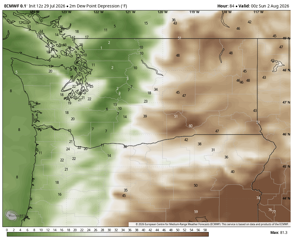
For now, smoke will stay away from Western Washington as we maintain an extended period of onshore winds, which keep us under the influence of clean, ocean air.
We are fortunate that this onshore wind pattern looks to last for a vast majority of the next several days — there may be a brief period of offshore winds the middle of next week that could blow smoke this way but it looks short-lived. (With our onshore flow, that smoke from fires across Oregon and Washington is instead getting carried east across the rest of the U.S. and southern Canada :/ )
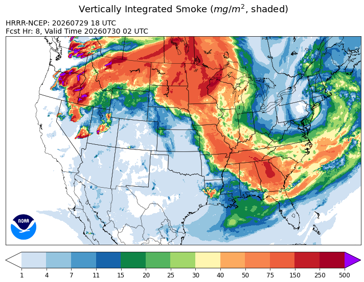
MORE: Here is how to find and read wildfire smoke forecast models for Seattle and the U.S.
But we’ve still got about a two-month window where we can get an extended period of hot weather with offshore winds that would carry smoke west into Western Washington, so we’re all in this together to hope we can get some rain over the wildfires sometime soon.
However, Eastern Washington’s long range forecast remains blank for precipitation.