Multiple atmospheric rivers eye Seattle area with soggy, windy storms through next week
 Scott Sistek

Move over, Polar Vortex, there’s a new weather buzzword filling up your social media feeds. And unlike the PV, this one has legitimate relevance to the Pacific Northwest:
Atmospheric Rivers.
“Theyyyyyyrrre baaaaaaacccckk.” (Though not as scary as a Poltergeist).
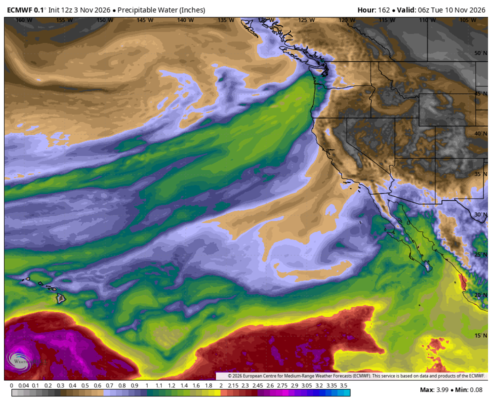
The weather pattern is looking to get gradually but increasingly stormy over the next two weeks as we get into the meat of November. And yes, some of these storms do likely qualify as “atmospheric rivers”.
WAIT, REALLY? WHY ARE ALL THESE STORMS CALLED ATMOSPHERIC RIVERS NOW? ISN’T IT JUST, YOU KNOW, RAIN?
It is rain, but it’s not just generic rain, it’s “special” rain, borne of the tropics. Just like there’s regular coffee, and then there’s Kona coffee. There’s regular rain, and then there’s *tropical* rain.
To recap since it’s been a while since this term has had the microphone: “Atmospheric River” is an actual legit weather term and is somewhat literal — it’s a term used to describe a plume of tropical moisture that carries excessive amounts water vapor and brings heavy rainfall.
The term’s origin is because the plume makes a nearly literal river of water in the atmosphere — by some counts, a typical AR can carry more water than 27 times that of the Mississippi River.
That becomes an issue when AR’s make landfall — and especially so when it hits coastal mountain ranges that in essence “squeeze” out the moisture from the AR and produce heavy rainfall.
Thus, strong AR’s can become problematic with high flood potential when they hit the Olympic Mountains and Cascades in the Pacific Northwest, and the Siskiyous and Sierra Nevada in California.
The term has been in the weather books for eons, but is only become popular in recent years because, you know, the internet loves a good SEO search term.
It doesn’t describe all storms — like the rains we’ve had the past few weeks? Not atmospheric rivers.
OK SO THEN WHY IS IT GETTING USED SO OFTEN NOW AND IN THE FALL?
Because in late autumn and winter during our stormy season, the weather pattern can become conducive for weeks (months?) for multiple atmospheric rivers, where a strong Pacific jet stream will dip and tap into warm, tropical moisture to the south, then shuttle it into the West Coast — many times into the Northwest; sometimes into Northern or Southern California.
A full winter stormy season can see dozens of official AR’s from October to March along the West Coast.
Not all AR’s are bad – many of them bring beneficial rains that don’t overwhelm our drainage systems and keep our reservoirs full. The next couple of AR’s on tap this week fall into that category.
But the signs for next week point to potentially stronger ARs that may start tipping over into more harm than good category.
SO WHAT IS THE AR FORECAST THEN?
The first one in the series is looking quite weak and will just bring a brief period of rain Wednesday evening into Wednesday night.
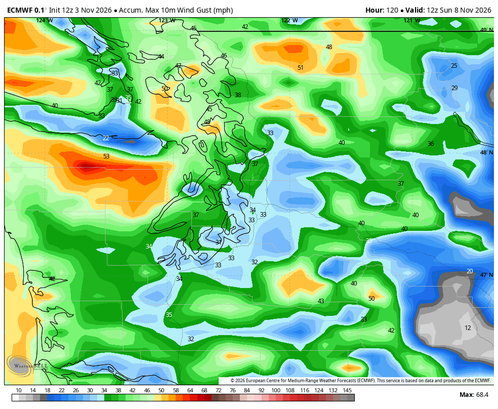
After a lull Thursday, a little bit of a stronger AR storm comes in for Friday into Saturday – though still not too bad; count this one “pretty typical” for November. We’ll expect periods of steady, moderate rain and gusty winds, with potential for low-end wind alerts needed along the coast and Northwest Interior.
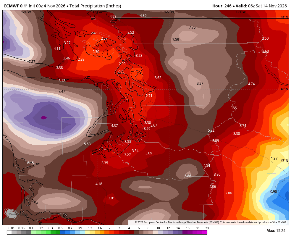
Rain and wind will taper off as Saturday progresses, with another system on the heels for Sunday. By the time we get to Sunday night, the Puget Sound area may have about 1,0-1.5” of total rain up to that point (though note the rather pronounced Olympic Rain Shadow over the North Sound.)
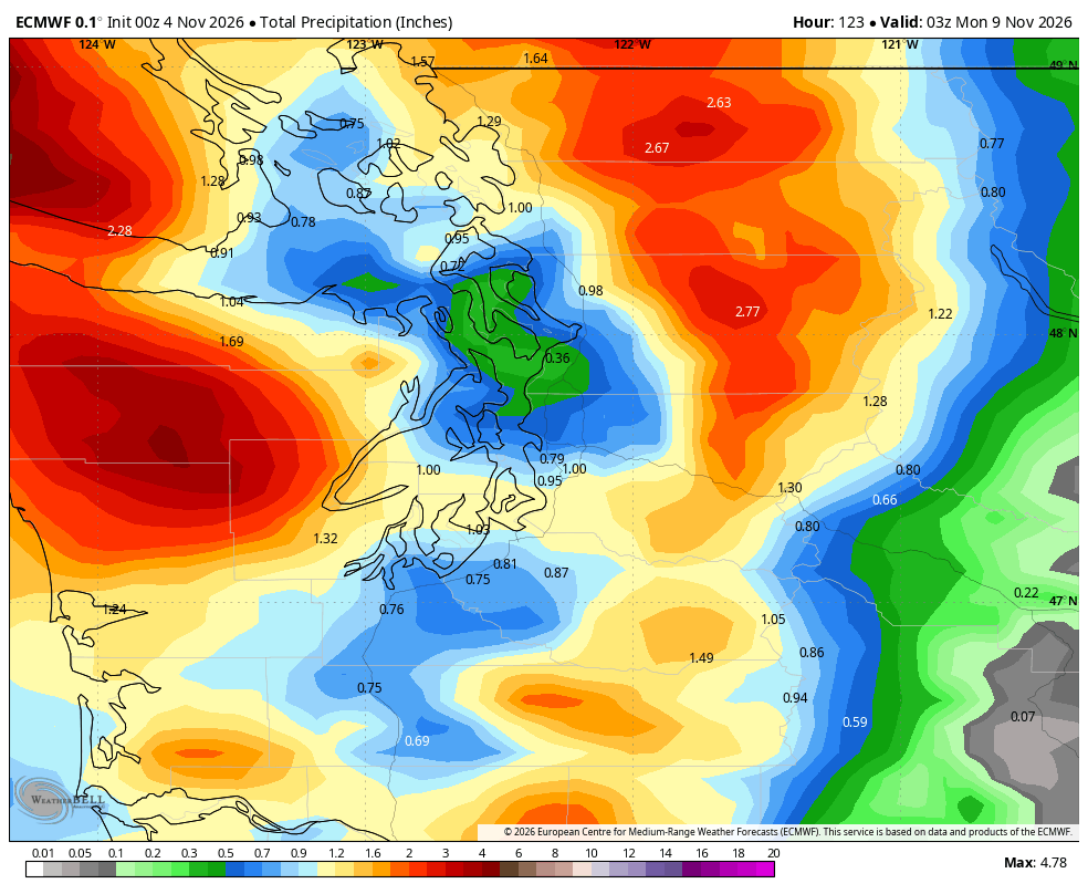
The lower and mid-elevations of the mountains may have 3+” of rain with the weekend storms.
Benjamin Jurkovich gives a forecast update via Washington Weather Chasers
The higher elevations of the Cascades, like above 5,000 feet, should get some snow out of these as well. But overall through the weekend, just an increasingly wetter and breezier pattern, yet nothing too impactful.
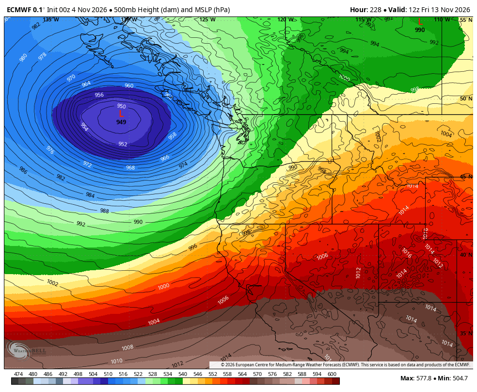
But long range models are suggesting the weather pattern will intensify next week and become a bit stormier. There is potential for not only heavy rains at times with stronger AR storms, but increasing wind potential too as we may see some strong low pressure centers spawn in the neighborhood.
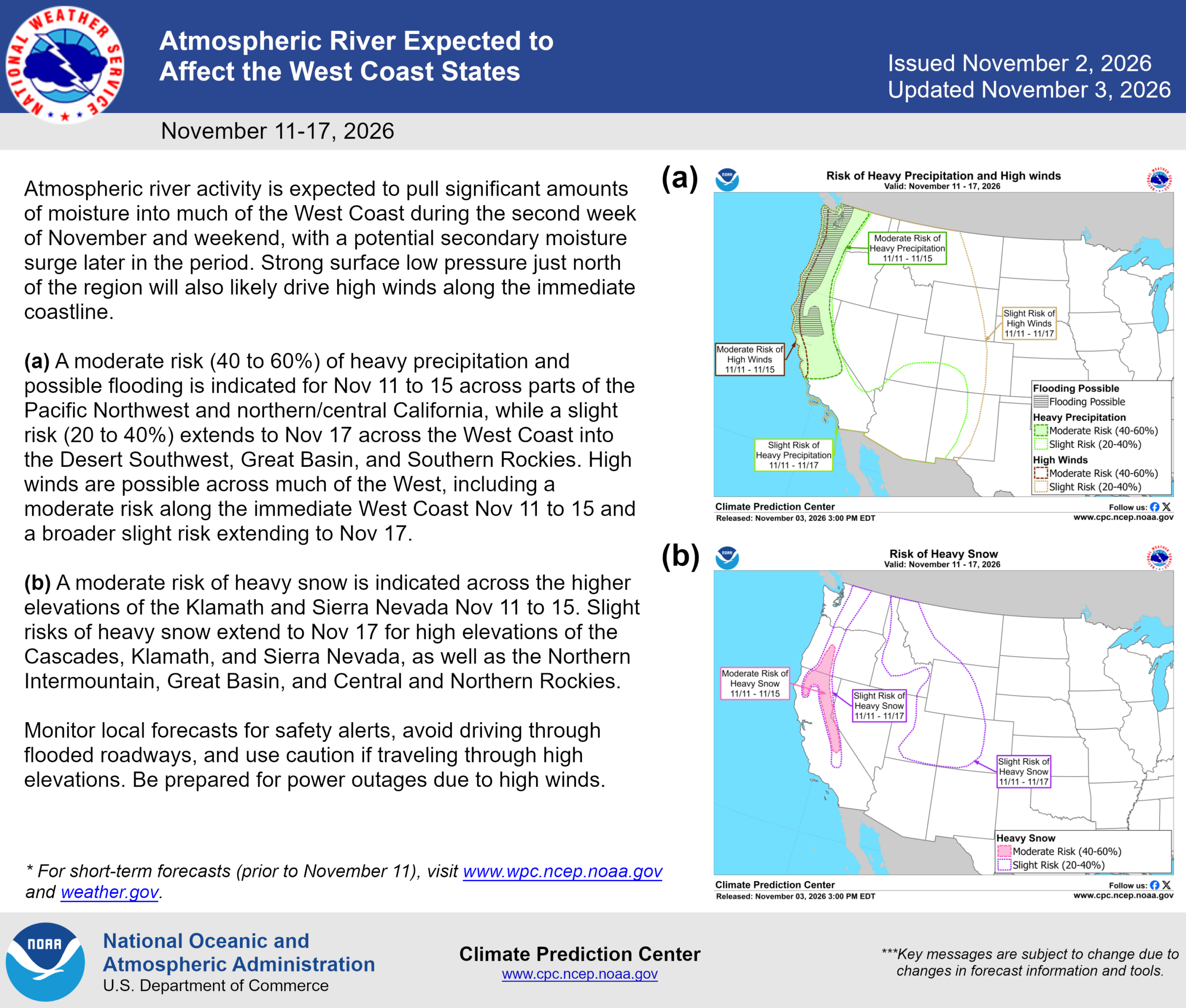
It’s too early to tell when/how many and how strong, but NOAA is giving a moderate risk (40-60%) of heavy rain along the West Coast within the Nov. 10-12 time frame and a moderate chance (40-60%) of high winds in the Pacific Northwest between Nov. 10-14.
FWIW, the forecast models have been honing in a bit on Friday Nov. 13 as a potential window for a strong wind event in Western Washington. That would be quite a coincidence because Friday, Nov. 13, 1981 is the date of one of the strongest wind storms in Pacific Northwest history.
NOAA is also highlighting potential for heavy high-elevation mountain snow next week but these storms are likely going to be too warm for much snow in the lower mountain elevations.
So November is about to November in Seattle, and that means we’ll be hearing a lot about atmospheric rivers. Sorry Polar Vortex, maybe you can get some attention in next month’s weather feeds…
MORE TO EXPLORE:
- Why Seattle shouldn’t have to worry about this historic Polar Vortex event in the making
- Las Vegas rallies to beat Seattle in October rainfall with just minutes to spare
- What is a Kelvin wave? Why Seattle shouldn’t need to worry much about El Niño’s sidekick