
Upper atmospheric height anomalies map showing a massive ridge of high pressure over the Pacific Northwest.
BEHOLD THE ‘MEGA’RIDGE*
(*This is not an actual weather term.)
Well, if you like weather happening, best advice is to take the rest of the week off… and head anywhere but the West Coast. However, if you like calm weather with hints of sunshine and freakishly warm winter temperatures, then best advice is to take the rest of the week off and go anywhere you want on the West Coast.
(I guess that makes a great TL;DR for this post: “Scott says just take the rest of the week off.”)
As promised, the last morsels of rain that we’ll likely see for hundreds of hours are heading north of the border Monday night as high pressure starts to build in from the south.
It’s a ridge of high pressure that WILL. NOT. BUDGE. FOR. DAYS.*
(*-Well, it might drift around a little, but you get what I mean…)
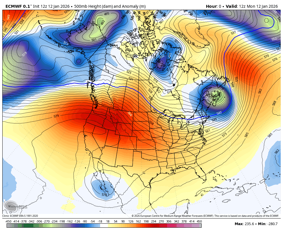
Behold: MegaRidge. That’s what I’m calling it. Others around here in the weather community have other nicknames for it. Skiers’ choices for nicknames might not be printable.
The kickoff Tuesday will bring near record-warmth to the area, as in highs in the mid-upper 50s. We won’t quite clear out all the gray just yet, but no matter, it’ll be “this can’t be January” warm outside. Seattle’s record high is 58 and we’ll be close.
We start to clear out a little bit mid-week, but that means also introducing a better chance of morning fog, especially in the valleys. But get out of the fog and it’l be mostly sunny and mild.
A weak front will make a lame attempt at defeating MegaRidge and will fail miserably, shredding apart and maybe just tossing a few passing clouds our way from its fractured remains. But this attempt will only anger MegaRidge more.
By the end of the week and into the weekend, it’ll be on full blast.
Overall in the general sense, it’s sunny and very mild with highs into the 50s, but the light winds from nary a low pressure center for hundreds of miles will aid in creating strong inversions that will trap cold air from the nights near the ground.
That will create more areas of dense fog that could be rather stubborn, especially in the South Sound and valleys where in the fog it can be in the 30s until the sun breaks through and temperatures rapidly warm into the 50s. And it may lead to wild variations in temperatures around the area depending on who’s in the inversion (30s) and who’s busted out (50s).
But if you want guaranteed warmth, ironically head into the mountains which will be above the inversion and into the 50s, if not 60s on some of the warmer days where we might get a little east wind-boosting warmth. It’ll be great skiing this week… at first. But as this goes on I suspect it’ll go from “Woo” to “Meh” to… some of those words that you can’t print.
The ridge holds well into next week for more sunny/foggy and mild days. Sun fans, this is about as much as you could ever dream about getting in a Seattle January.
Photographers, here’s your week-plus time of getting in those elusive sunny winter photographs. The folks watching the Seahawks game Saturday won’t believe their sunny screens and will swear the NFL messed up and gave Seattle a road game. (But then the field will look in good shape and thwart that idea 😉 ) We’ll just have to watch if we get air quality issues with the trapped inversions.
This weather forecast map below is just ridiculous for January. The rather blank-looking map shows the forecast rain totals… COMBINED FOR 7 DAYS! It’s blank across the entire West! (Aside from some patchy fog-drizzle 0.01” “rains” near the water.)

WHEN DOES ‘MEGA’RIDGE DIE?
Long range models are hinting that MegaRidge finally… well it doesn’t really “die” so much as perhaps shift off away from us sometime at the end of next week.
If you winter fans want your latest rendition of Lucy holding the football for Charlie Brown, some models are hinting the ridge will move back to the west into Alaska, which would open the door for arctic air to push down from northern BC.
That would actually follow somewhat the script of how last winter went with its weak La Niña: Wet November/December, super dry January and then cold start to February.
Alaska would probably welcome a MegaRidge visit with open arms after their record cold and snowy winter so far. Local skiers just want their snow back. Sounds like a good trade to me!
It does seem like we are following last winter’s script quite closley. Just with a whole lot more flooding.
This current period of dry, calm, somewhat-sunny (at least on the coast) weather is most appreciated!