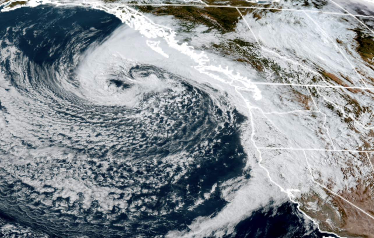
GOES-18 satellite image from the morning of Sept. 30, 2025.
The first autumn storm of what I’m sure will be several others this season is upon us this week, promising rounds of steady rains, blustery winds, and even in a bit of an unusual twist, maybe a few lightning strikes.
IS THIS STORM A BIG DEAL?
In the grand scheme of things, no, not really. The center of the storm is currently moderately powerful offshore, especially by late September (technically) standards. But the storm center won’t make it inland, instead starting to fill in and falter as it meanders offshore. But it will swing a decent sized front through later Tuesday and that will kick up the rain and, in some places, a few hours of decent wind gusts.
(FYI: THIS NEXT SECTION IS BROUGHT TO YOU BY MY YOUNGER SISTER KIM):
But you know how the first born kids get all the attention at first?
“OOH! Grab the camera! He’s rolling over the first time!”
“QUICK! Grab the camera! He’s working on taking his first step!”
“AWWW! GRAB THE CAMERA! HE’S ABOUT TO TRY FOODS THAT START WITH AN ‘M’ FOR THE FIRST TIME!!!”
Then the second kid comes along and does that and it’s like: “Yawn, whateves, we’ve probably seen somersaults while balancing a bottle before….”
This storm is getting the “GRAB THE CAMERA” treatment because it’s our first of the year. It is rightly deserving of some headlines: Our region is more vulnerable to power outages during the first windy event of the year because the trees still are leafy and haven’t shed their dead branches and stuff from the dry summer yet.
However, I’m not sure this storm will even qualify for that concern over about 80% of the region as the wind speeds really are not expected beyond “blustery”, but let’s break down what we ARE expecting this week.
‘EXPECTING’? NOT ANOTHER LITTLE BROTHER I HOPE?!?
Just more rain and wind! (That I know of… Feel free to use the comments for any surprise birth or gender reveal announcements though!)
The bumpy weather will come in two rounds — first with the front on Tuesday, then blustery showers and isolated thunderstorms Wednesday into early Thursday.
The first round of steady rains and gusty winds will push through reaching the coast around midday Tuesday and mid afternoon around Seattle/I-5 corridor, and stick around into the evening.
WASN’T THERE AN ASTERISK EARLIER WE NEED TO CLEAR UP?
There are the season’s first fall-storm Wind Advisories posted for the coast and San Juan Islands. (I put a * because technically we just had a Wind Advisory for the Cascade foothills during that east wind event that made Mt. St. Helens’ blowing ash look like it was erupting a few weeks ago…)
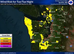
Coast Wind Advisory is from 11 a.m. to 8 p.m. Tuesday; San Juan Islands is from 2-11 p.m. Tuesday. Both areas could see gusts up to 45 mph — that’s the bare minimum for a wind alert but again, first of season so GRAB THOSE CAMERAS! I mean, watch out for leafy tree power outage issues.
For the Seattle/Puget Sound corridor, we’re looking at gusts of 20-25 mph, maybe a few 30s. Noticeable but not impactful.
WHEN ARE THE THUNDERSTORMS? THEY LOOK SOOOO CUTE ON THE RADAR!
Wednesday and into early Thursday will feature a change to just getting peppered with showers all day as the broad area of low pressure gradually fizzling offshore just spins cool, unstable air into the region.
It’s marginally unstable enough (Sister: “Like Scott trying to get dressed for school in the morning!”) along the coast closer to the low that there is a risk of thunderstorms over there during those two days. You can see on the map below from NOAA’s Storm Prediction Center they have painted areas west of Puget Sound in a general risk of thunderstorms (nothing severe).
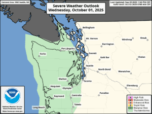
The risk is not zero, but is much lower inland and east of Puget Sound farther away from that low. I wouldn’t be surprised if we get a few claps of thunder, but mostly the day will feature the occasional drenching of rain and punch of wind, followed by random bursts of sunshine.
But there will be a renewed round of blustery winds on Wednesday and Wednesday night as the low creates just enough pressure gradient to blow things around. Perhaps about +5-10 mph over Tuesday’s winds — still not overly concerning, but you’ll hear it.
The good news is this storm system should indeed really squelch the fire season over here — the Olympics are looking at up to 4-7 inches of rain through the storm system, with about an inch to 1.5” in the lowlands combined over the next few days.
WHEN WILL THE WEATHER STOP BEING SUCH AN ATTENTION HOG?
Once we wade through this first storm, the weather actually trending drier over the weekend into early next week, with comfortable highs around 70 and very crisp, cool autumn mornings with lows getting into the 40s! I know what I’ll be turning my attention to: Pumpkin Spice Lattes!*
(*-Not really. I’m more a plain latte fan…)
(And fellow big brothers/sisters, give your sibling a hug. And maybe take a photo or two so they have a few…)