
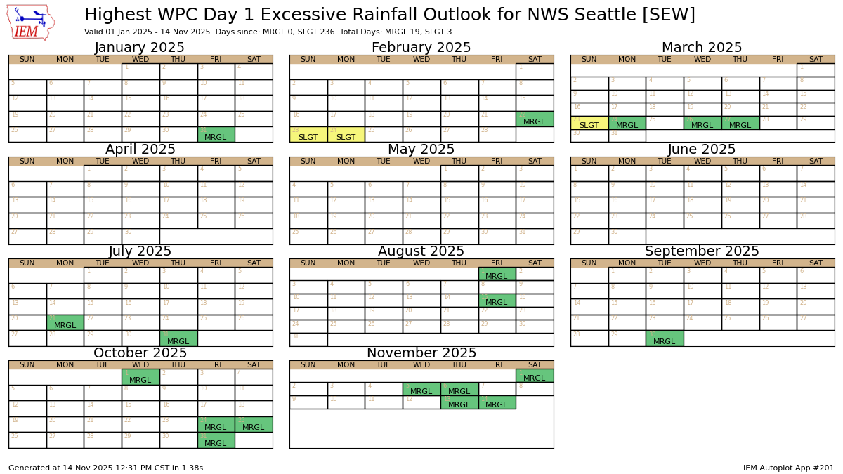
NOAA Weather Prediction Center Excessive Rain Outlook Nov. 14.
Those who regularly peruse weather maps may see one for Friday from NOAA’s Weather Prediction Center that paints a large swath of Western Washington in a green shade for “Excessive Rainfall.”
Among its duties, the WPC monitors for the potential for flash flooding from heavy rains and will highlight risk zones on a 1-4 scale: “Marginal”, “Slight”, “Moderate” and “High.”
The atmospheric river storm that has been moderately drenching Western Washington Friday had enough rain in the forecast to warrant a level 1 “Marginal” flash flood risk. It covers the Puget Sound area, Olympic Peninsula and the Northern Cascades.
“Potential for an additional 1 to 3 inches for the Olympics and Cascades through (4 a.m.) Saturday,” the WPC wrote. “The lower end of that 1-3 inch range is anticipated for the Olympics with maxima of 3 to perhaps 4 inches in the Cascades with rates likely staying below 0.5 in/hr. However, wet antecedent conditions will continue to warrant a Marginal Risk for the region.”
Level 1 risk zones are actually not that uncommon. This is the 10th time somewhere in NWS Seattle’s jurisdiction there has been a Level 1 risk just since Sept. 30, though we haven’t seen a Level 2 risk since March.
Some issues are already popping up around the Puget Sound area as a particularly stubborn band of rain was stuck right over the region late Friday morning. It’s causing some low-lying areas to flood and thus the NWS has issued a Flood Advisory for essentially the Seattle/Puget Sound area and Kitsap Peninsula.
Already about 0.8 to 1.5 inches have fallen with another half inch or more due in the rest of Friday.
Flood advisory has been issued for the south sound till 3:15 PM this afternoon for urban and small stream flooding.
Rainfall amounts through 11 am:
NWS Seattle: 1.15″
Bremerton: 1.11″
Boeing Field: 1.10″
Olympia: 0.33″
Everett: 0.10″
Bellingham & Chehalis: 0.00″#wawx pic.twitter.com/5AvJWdiAYU— NWS Seattle (@NWSSeattle) November 14, 2025
WOW! WHAT’S WITH THE RED BLOB OVER LOS ANGELES?
The rainfall situation is more dire over Southern California, where the brunt of the AR is focusing its wrath right on top of the Palisades burn scars and the heart of Los Angeles. The WPC is giving a Level 3 out of 4 risk for flash flooding there.
Rainfall rates could reach 1 inch per hour in the surrounding hills and several inches for a storm total by later Saturday. The level 3 risk persists into Saturday and the NWS says “numerous flash floods are likely” in that zone.
WHEN DOES OUR RAIN END?
March? April? Oh you mean literally…
This storm will taper off by Saturday morning with just kind of spilled leftover showers mulling around the rest of the day. Another weak system will bring light rain at times Sunday into Monday and then the pattern takes a little change…
The long range models suggest a brief dry break mid week, but also some cooler weather filtering in. Nothing significant yet, but we could drop to highs only in the upper 40s with lows in the upper 30s. Rain looks to return toward the end of the week.
Super long range models are still trending even a bit cooler as we get into Thanksgiving week. That bodes well for starting to get some snow to stick in the ski resorts!