Where have these storms been all winter?
It’s about to really look and feel like January out there for the next few days, but really, it should be welcomed with open arms. Even the sun fans should be able to get on board because, spoiler alert, you’ve got a payoff in the works soon.
The only ones frowning will likely be those who have to drive over the mountains because that is about to get challenging.
We have two storms coming in back-to-back out of the Gulf of Alaska this week. For the record these are NOT atmospheric river storms, just to quell the notion that we now call every storm an AR. (But really, most of those in November and December WERE atmospheric rivers.)
But they ARE going to be big snow makers… in the mountains. Winter Storm Warnings are up there from Monday night through Thursday to cover both storms.
The first storm is coming early Tuesday morning and will be a cool, windy day in the lowlands with even potential for some stronger, gusty winds up north along Bellingham/Whatcom County and over into the San Juans, where a Wind Advisory is in effect for gusts of 40-50 mph. For the rest of us, including the Seattle/Puget Sound area, it’s not windy-worthy enough for any alerts (about 25-35 mph), but it’ll make for a noticeable wind chill (by our puny winter standards).
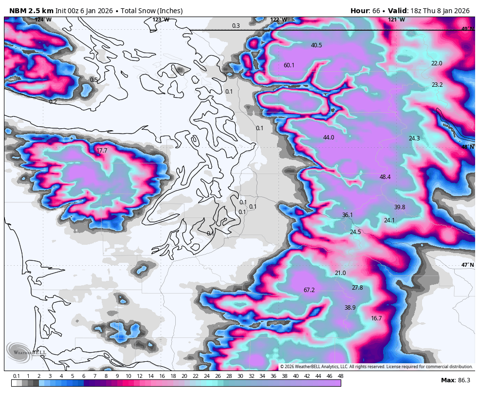
Adding to the chill, a steady rain at times for much of Tuesday while the first round of gobs of snow pummel the mountains. We’re looking at about 10-20 inches at Snoqualmie Pass and 1-2 feet+ at Stevens Pass.
And that’s just Round 1!
Storm No. 2 comes right on the heels Wednesday into Thursday for renewed lowland rains and mountain snows. We’re looking to add another 1-2 feet on top of the first storm, with storm totals then of 2-4 feet across the Cascades and Olympics.
But this storm taps into a little bit of even colder air, dropping snow levels down as low as 700-1,200 feet in the far North Sound. With likely active Puget Sound Convergence Zones running around in the northwesterly winds behind the storms, we could see some areas of rain/snow mix or even wet snow in the higher lowland elevations later Thursday into Thursday night.
Alas, this is not the “snowstorm” you are looking for; any snow will be wet and brief and won’t last long after the snow or rain stops. We’re not exactly going into a deep freeze. But areas from Snohomish County northward, especially with a few hundred feet elevation and in the usual Convergence Zone spots may see a little snow at times. Elsewhere, more chilly rain! (And maybe some rumbles of thunder along the coast.)
I DIDN’T FORGET ABOUT YOU, SUN FANS
By Friday morning, we’ll have had a few days of soaking, chilly rains with maybe some jealousy-inducing snow showers, so it’s time to start giving sun fans their due. It won’t be a quick process, but high pressure will slowly build in on Friday and Saturday, leaving just a few showers Friday and a mostly dry Saturday on tap.
The long range forecasts have been in general agreement that next week may feature a switch to dry and warmer weather (Dare we say sunny?)
There are still a few model runs trying to nick the area with weak systems at times that may toss a few spot showers our way, but many others are thinking dry. And mild. There would be some areas of morning fog and frost to deal with but the afternoons could be quite pleasant. Hopefully the storms this week get enough snow up in the mountains to be able to weather a dry stretch guilt free.