Storm promises rainy, windy start to Seattle’s ‘meteorological autumn’
 Scott Sistek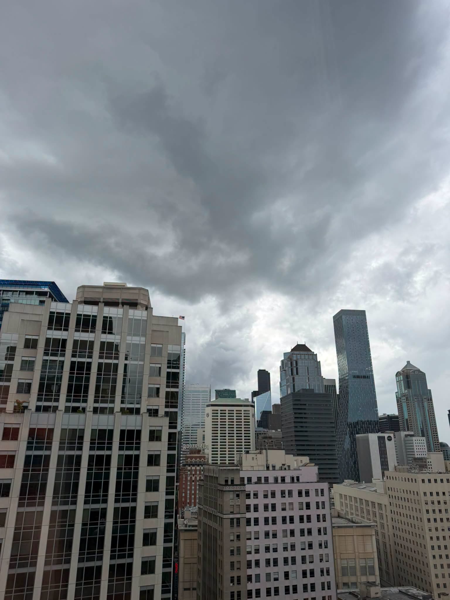
Storm clouds over Downtown Seattle on Sept. 2, 2026. (Photo: Benjamin Jurkovich)
Hours of steady rain? Gusty winds? Low-hanging clouds? There’s a storm a-brewin’!
I am not sure it rises to the level of any hatches that need battening down, but Western Washington’s first autumn storm of the year is on track for Wednesday.
(Yes, I get to say “autumn” storm because I’m a meteorologist and as far as I’m concerned, it IS now autumn. “Meteorological Autumn” runs Sept. 1-Nov. 30 for record-keeping ease, as opposed to those silly astronomers who continue to insist fall begins on the autumnal equinox on Sept. 22. Clean records > Earth equal daylight day 😉 )
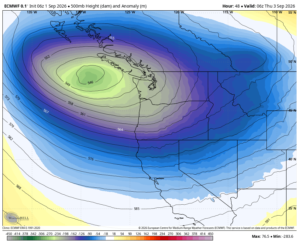
A potent area of low pressure will slide down from the Gulf of Alaska and along the B.C. coast this week, then spend days swirling around the Pacific Northwest. It’s sort of like an Alaska cruise in reverse where instead of leaving Seattle to spend a week in the Alaska Panhandle, it’s coming from Alaska to spend nearly a week around Seattle. (Just don’t make it too breezy near the flying fish at Pike Place Market…)
Clouds will increase around Western Washington on Tuesday as the storm begins its journey south, with even a few showers possible out in advance of the front later Tuesday.
The main event arrives Wednesday as the storm’s cold front begins to move through the region, bringing steady rains for several hours and eventually gusty winds.
The rain is exclusively beneficial — yay! We’re looking at about a half inch or more around Seattle and the Southern Puget Sound area plus the Cascades, with 1-1.5 inches in the Olympics. No real flooding concerns, just the perfect amount of rain to begin recovering from the summer dry season.
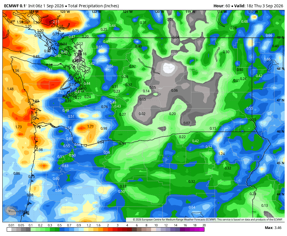
The North Sound will get a little less, thanks to the Olympic Rain Shadow getting its first workout of the season, but still plenty to get lawns and plants a nice drink.
OKAY, FINE, MAYBE BATTEN DOWN A *FEW* HATCHES….
Instead, the North Sound (and coast) will be the wind champions for this event.
All of Western Washington will be blustery through the day Wednesday, with frequent gusts of 20-30 mph. But winds will surge a little in the afternoon and evening as the main front passes through.
Peak gusts still look only to reach about 25-35 mph in the Puget Sound area, but could touch 40 mph along the coast and northern islands.
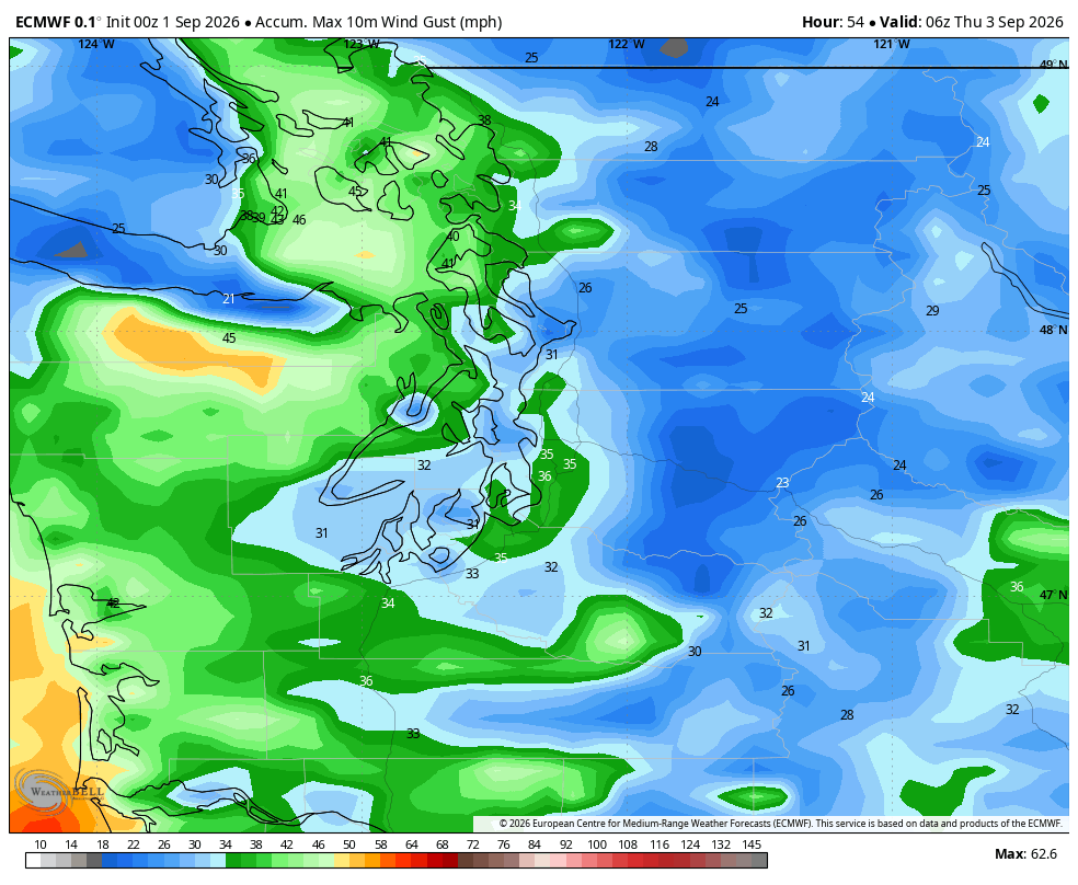
That’s enough to bring the first Wind Advisory of the season for the coast, San Juan Islands and Whidbey Island for much of the day Wednesday — until 5 p.m. on the coast and 8 p.m. on the northern islands.
Those wind speeds by autumn standards are pretty paltry — 8 weeks from now these kinds of wind gusts will barely rate a mention or a worry. But the first gusts of the season tend to be a little more impactful since the trees are still leafy and any dead branches that didn’t survive the dry summer haven’t had a chance to blow off and maybe mess with power lines.
Even still, for the Puget Sound area, 35 mph is pretty low-end wind for any impacts, even for the “first autumn storm power outage” worries. So I’d say impacts should be pretty isolated. (Hatches? Probably OK to leave un-battened…)
Thus, I reserve the right to re-play this card about first-wind-of-the-season-carry-more-impact in a future, stronger early season autumn storm (though none loom on the horizon after this one.) I’m usually not thinking impacts until 40-45 mph for early season issues. (Once we get into the heart of fall and winter, then I’d say impact threshold needs to get over 50 mph.)
The cold front will even bring beneficial, wildfire-blunting rains and blustery winds to Central and Eastern Washington too, just more into later Wednesday evening and Wednesday night there.
In the West, winds and steady rains will taper off Wednesday night, but there’s plenty more tricks up this storm’s sleeve.
YOU’VE GOT FRIENDS IN ‘LOW’ PLACES?
Once the front passes through, that will bring an end to the steady, widespread rains for this event, but in its wake will be days of a battle between showers and sunbreaks as the low pressure center gets stuck meandering around the Pacific Northwest, slowly fizzling as the days go by.
The most active day will be Thursday when the low still has most of its strength. This will switch the pattern to something similar to what we’ve seen over the summer before, where it’s roaming random showers that could graduate to thunderstorms — even in the Puget Sound area — as the low brings cool, unstable air to the local atmosphere.
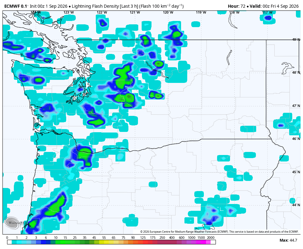
The forecast models are on the pretty low-end range for thunderstorm coverage and intensity though, and thus any storms should be more the “Northwest garden variety thunderstorms” and nothing severe. But those cells could bring brief periods of heavy rain, gusty winds, and even some small hail. Highs will stay in the 60s.
The forecast models are still having a difficult time trying to determine where that low is going from there. It’s becoming cut off from the main flow of the regional atmosphere, so it’s trying to predict a storm that is sort of wandering around like a wobbling spinning top that is nearing the end of its spin.
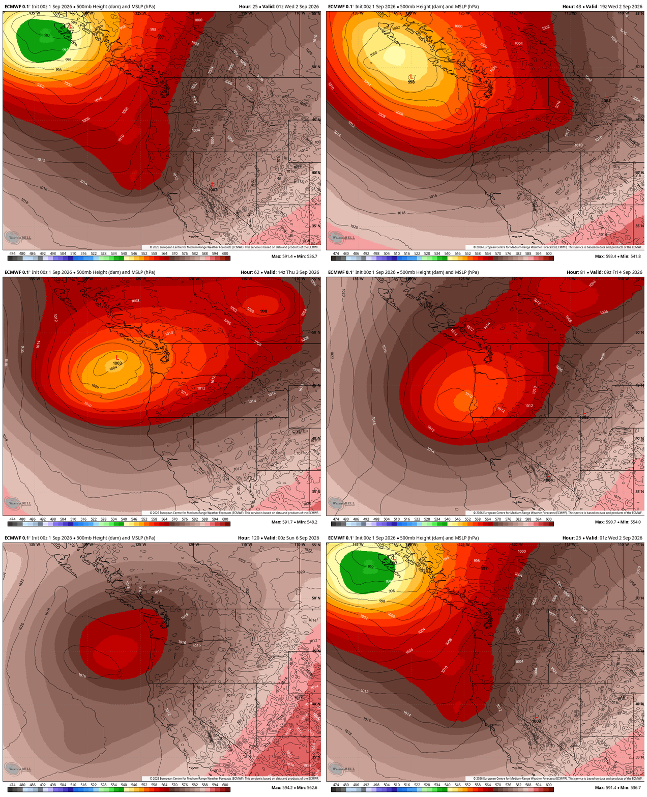
It appears at some point over the holiday weekend it will start to move inland from somewhere off the Washington or Oregon coast and be out of the Northwest’s hair by Sunday or Monday.
About the only consensus is that the low will be weakening as we get through Friday and Labor Day Weekend, increasing the ratio of sunbreaks to showers as the days progress.
So overall, call Friday through Monday gradually decreasing shower coverage and increasing sunbreaks, but any showers that do find you could bring a brief downpour. Also one caveat: The area where the low tracks may see a period of increased showers as the low center passes by. (And sadly, these hit-and-miss showers have a better chance at being thunderstorms across central and eastern Washington.)
Sounds like a typical maddening three-day holiday weekend Seattle forecast to me: Sunny at times with surprise and random drenchings. Maybe get in that hair gel refill order in now before the crush.
WHAT HAPPENS AFTER THAT? EL NIÑO WEIRDNESS?
The long range forecasts are pretty much worthless right now since the models still can’t even get a good grasp on the wandering low’s intentions, which affects what happens next.
But that’s not to say they haven’t been interesting…
A glance at the Pacific Ocean satellite image over the tropics shows something straight out of a surreal Super El Niño villain montage: Not one, not two, but THREE tropical storms and hurricanes swirling out there: Hurricanes Lowell and Karina, and future Hurricane Marie.
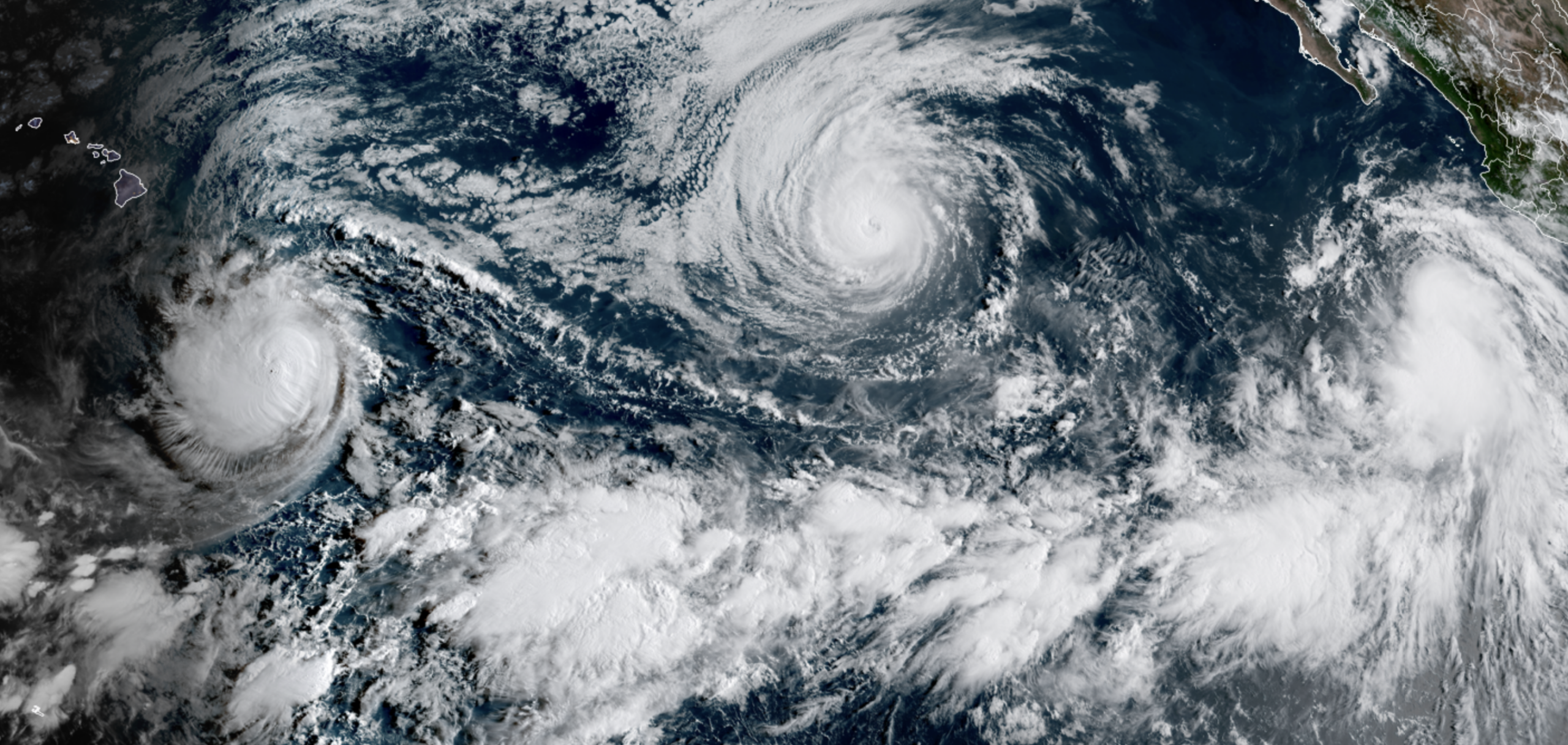
An active Pacific tropics season is expected in El Niño years as wind shear weakens in the Pacific, combining with warm ocean temperatures to fuel tropical systems.
Somehow, Hawaii is acting like Keanu Reeves in the Matrix and dodging all those tropical bullets for now — none of those storms are forecast to trek close enough to have any significant impacts to the islands.
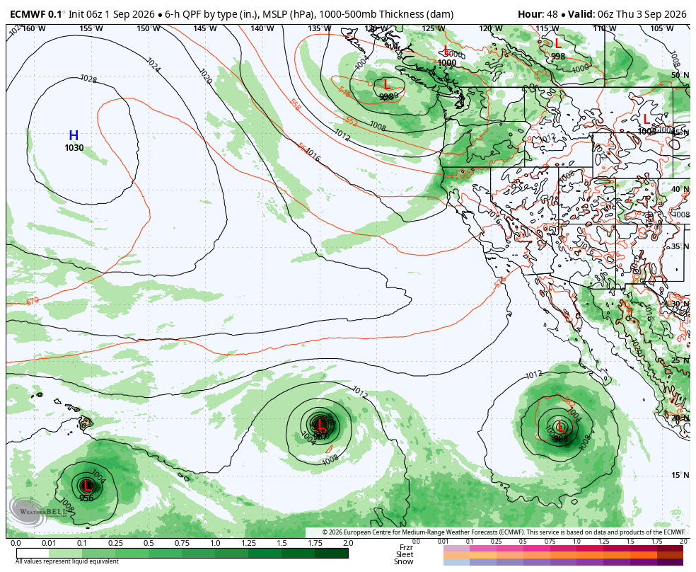
That part of the forecast is pretty solid. The next part, not so much. But since it’s been percolating across other social media feeds…
*Some* forecast model runs had latched onto an idea of moving Marie (the eastern most of the tropical trio) north up near Southern California over the holiday weekend, where its moisture could bring heavy rain to the Desert Southwest — that in turn could get vacuumed up into the Pacific Northwest for a new round of rain that would be more tropical/monsoon fed.
More recent model runs have instead pushed Marie harmlessly out to sea to the west leaving California tropical-rain free and in turn, the Northwest too. But feels like even if this particular scenario turns out to be a miss this time, that sort of pattern could emerge at some point during our budding El Niño autumn…
THEN, maybe you can batten down all the hatches.
LEARN MORE ABOUT SUPER EL NIÑO AND ITS EXPECTED EFFECTS ON NORTHWEST WEATHER:
Speaking of El Niño, I was invited to come on to KUOW’s Seattle Now podcast Tuesday morning to chat about what makes El Niño and what are some of its potential impacts across the Pacific Northwest:
MORE TO EXPLORE:
- Seattle took just 10 minutes to thwart a rain record Saturday
- What are some scenarios a historic ‘Super El Nino’ could present for the Pacific Northwest and California?
- Sunset and severe thunderstorms spawn spectacular sights over Vancouver Island