Strong atmospheric river system threatens flooding, winds as Hurricane Hunters may now investigate
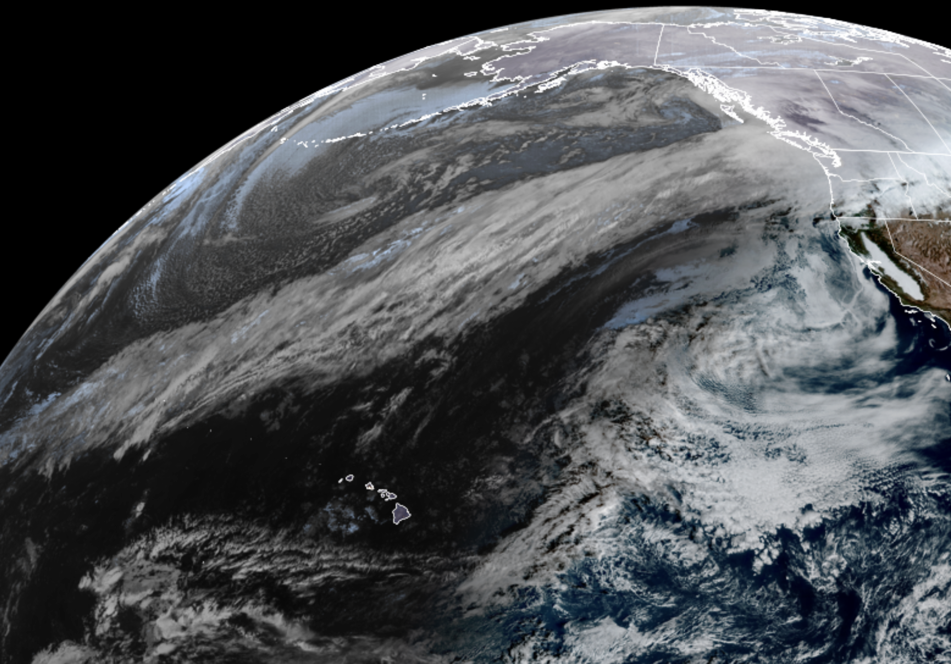
GOES 18 Satellite Image Dec. 8
The start of a 3-day period of really wet weather is under way as a strong atmospheric river revs its engines and begins its onslaught on western Washington and northwestern Oregon.
MORE: What is an atmospheric river?
The forecast is still holding steady of heavy rains through Wednesday with several inches of rain both in the lowlands and especially the mountains, with widespread river flooding commencing as early as Monday night and peaking in the middle of the week.
This morning’s satellite loop of water vapor in the mid levels of the atmosphere. That’s a pretty substantial feed of moisture aimed at southern British Columbia and the Pacific Northwest. It extends roughly 3500 miles offshore…or well to the northwest of Hawaii. #wawx pic.twitter.com/I3HfwIhaij
— NWS Seattle (@NWSSeattle) December 8, 2025
The AR rating folks are still going Category 4 (out of 5) on the storm.
It’s enough that NOAA has requested an Air Force Hurricane Hunter (TEAL 71) make a flight into the storm on Monday to gather data and feed into our forecast models.
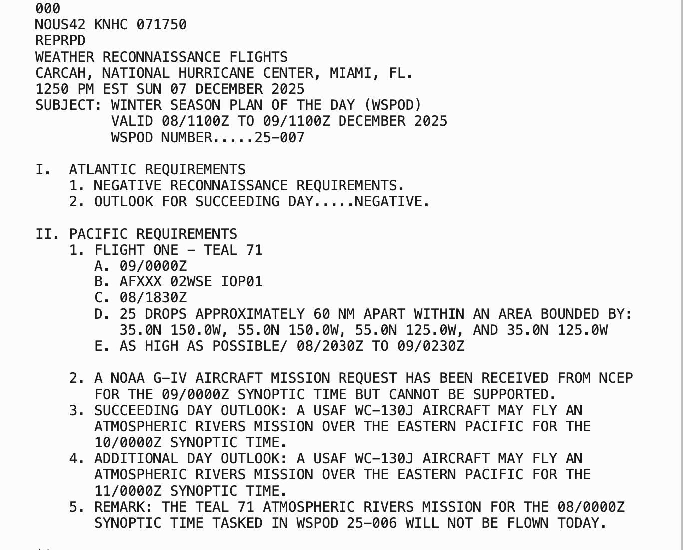
“25 drops” means dropping “dropsondes” — small cylinders that collect and transmit weather data as they fall through the storm. Think of it like a reverse weather balloon.
The results would provide crucial real-time weather data to feed weather forecast models over an area where weather observations can only came form satellite sensors or occasional ship and buoy reports.
WAIT, ‘HURRICANE HUNTERS’ ON THE WEST COAST? FOR ATMOSPHERIC RIVERS?
Yes! But it’s not unusual, nor does it signal a particularly dire storm.
Now that the Atlantic hurricane season is quickly winding down, it’s the West Coast’s turn to take advantage of the hearty aircraft and storm expertises of the research teams and their pilots to go “hunting” some of the West Coast’s most powerful storms.
While there isn’t an “eye wall” to punch through and get dramatic scenes of stadium effects like in a hurricane, atmospheric river storms still carry strong winds and torrential rains fueled by a stream of tropical moisture and an intense jet stream that makes for anything but a smooth flight.
With the hurricane season over (ended Nov. 30), the Hurricane Hunters are available on “resources permitting status” in the Pacific through December, then usually fully assigned to the Pacific in January and February, according to Scripps Institution of Oceanography.
TIMING OF ATMOSPHERIC RIVER SYSTEMS:
The first wave is under way and will last through about midnight Monday night, then it temporarily shifts its plume to the south. There will be a brief lull in the rain pre-dawn Tuesday morning before the plume returns north on Tuesday and soaks us again into Wednesday.
Storm total rainfalls according to the NWS are still looking at about 3-6 inches from the central Puget Sound area and to the south, with about 2-3.5 inches north of Seattle, with the lower totals as you get closer to the Canadian border.
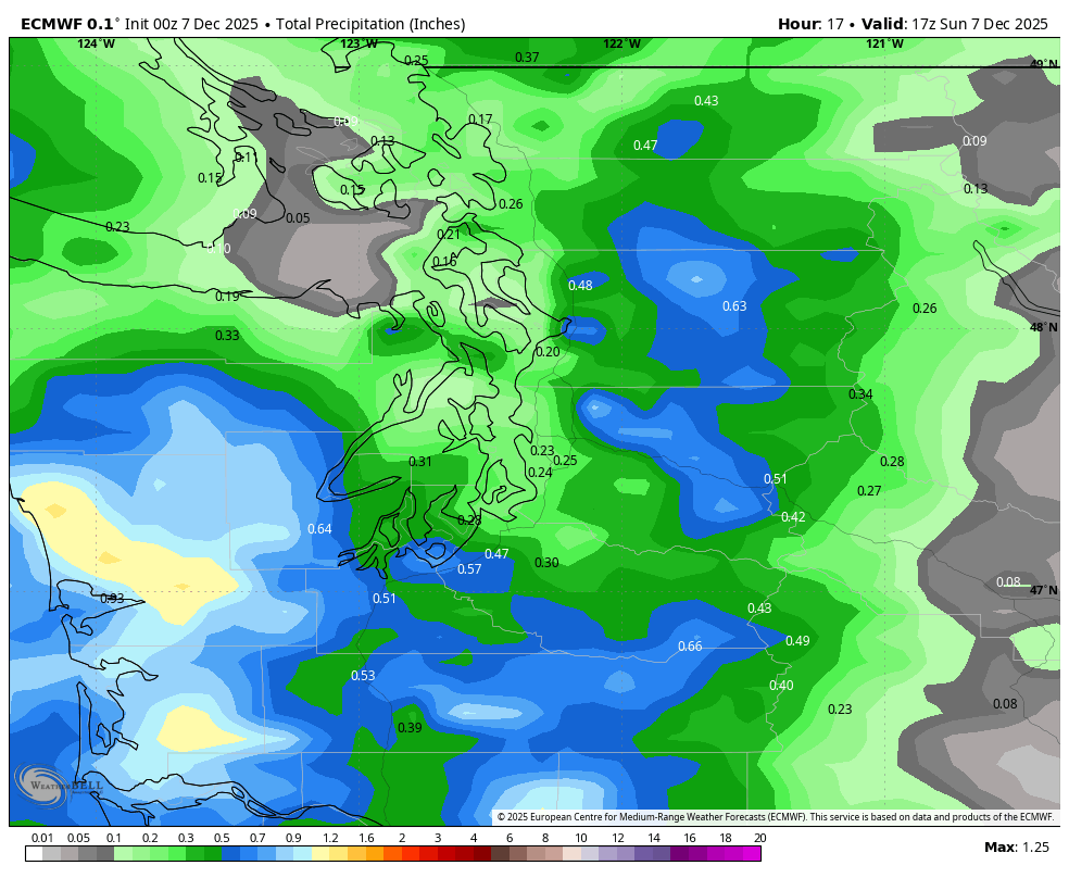
The Cascades are expecting 6-10 inches of rain with some spots getting over a foot. With the tropical moisture source, snow levels remain quite high and almost all this precipitation is coming as rain. That means still a very significant amount of rainfall and several rivers will flood, plus it’ll still cause widespread risks of landslides and mudslides and lead to areas of urban flooding.
GUSTY WINDS ON MONDAY TOO
We’ll also see a period of rather gusty winds starting around midday Monday and lasting into Monday evening as an area of low pressure rides the atmospheric river train and slides through right over the Olympic Mountains.
This will keep the strongest from about Seattle/Bellevue and maybe as far north as Everett, and then to the south into Southwestern Washington through the afternoon. Predicted gusts are of 40-45 mph — maybe even some rogue gusts to 50 mph. One the low passes in the evening, a surge of west wind will chase the low and come down the Strait of Juan de Fuca and into Whidbey Island and western Snohomish County for a second round of wind gusts in the 40-45 mph range.
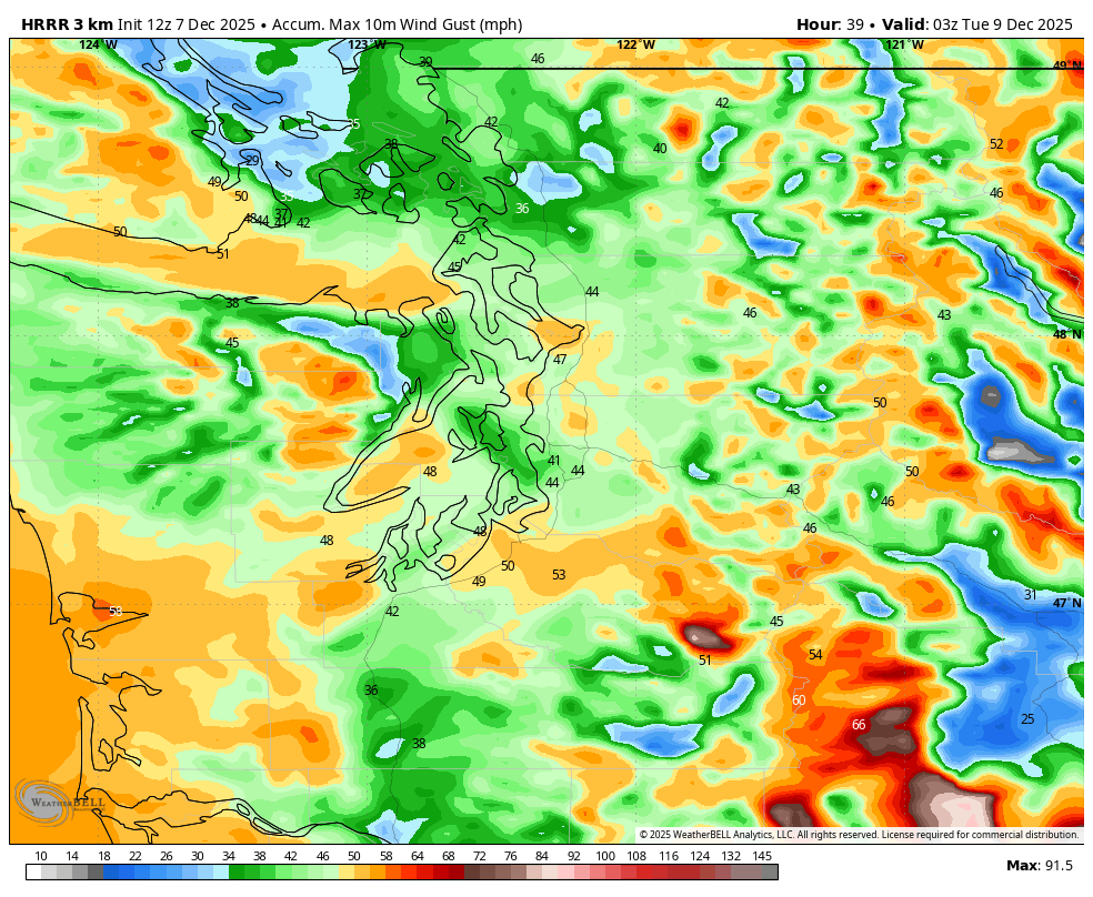
The region should be able to handle these wind speeds without too many issues, though the gusty winds of similar speeds Friday sneakily left over 10,000 without power in Seattle for a bit so just be ready. It’ll also make driving that much more challenging with all the rain.
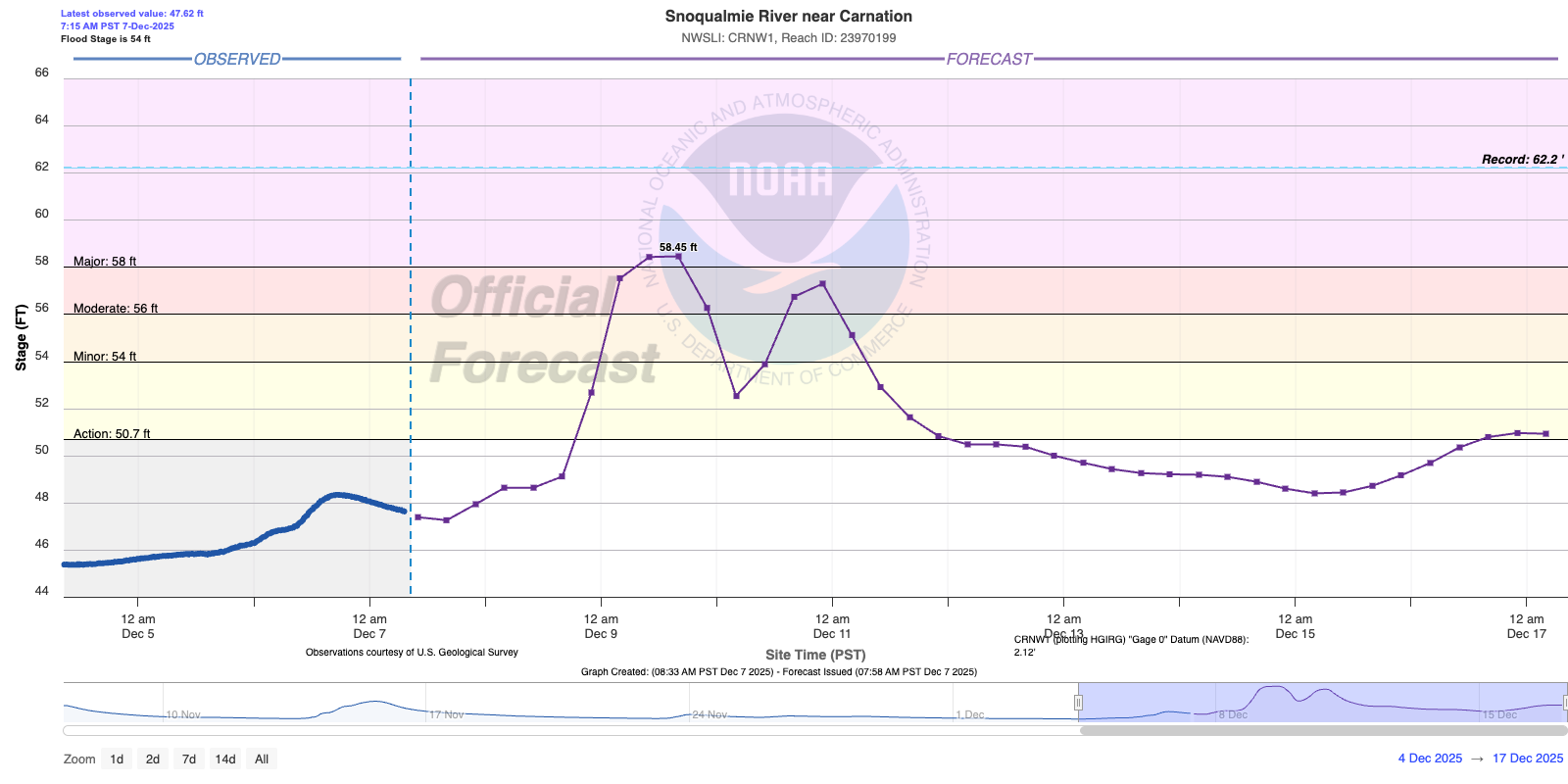
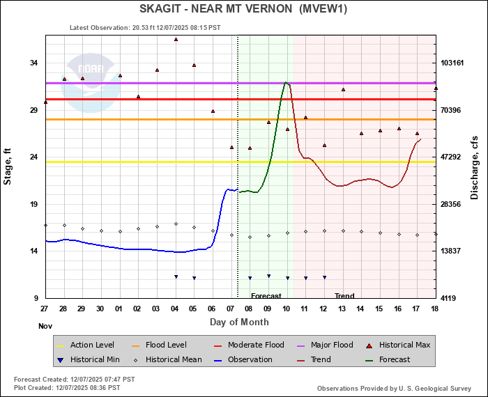
WHAT’S THE LATEST ON RIVER FLOODING IN CASCADES?
There is still widespread flooding risk across many Cascade rivers, even those in the north.
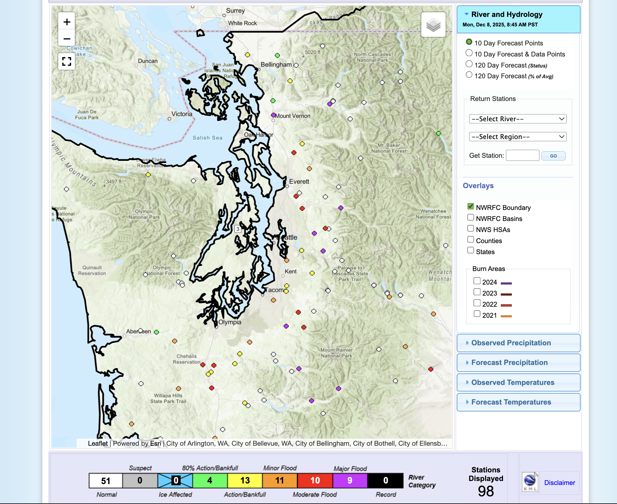
As of Monday the rivers still with the greatest flood potential are the Snoqualmie, Skagit, Skykomish, Nisqually, Puyallup and Cowlitz with all expected to reach or exceed major flood stage on Tuesday.
LINK: NOAA River Forecast Center / Latest river levels & flood forecasts:
Several other rivers, including the Snohomish, White, Carbon, Skookumchuck and Newaukum just to name some, are predicted to reach at least moderate flood stage.
Flood Watches remain in effect for all mountain-fed rivers in Washington through Friday morning.

WHEN DOES THE SOGGY PATTERN END?
This atmospheric river will start losing steam on Wednesday but long range forecasts indicate there may be even more rain in store later in the week.
These rainfall amounts would be much less than the main storm this week, but could slow the receding of swollen rivers. The 8-14 day long range outlook continues to look mild and wet for the Pacific Northwest.