FILE photo. (WSDOT)
(TL;DR: Quiet through Saturday. Pass travel issues loom Sunday into Monday, and again to start Thanksgiving weekend. Then it gets cold. Also: Duck puns.)
Happy Apple Cup Da…..oh drat, that’s right. That’s not a Saturday-before-Thanksgiving thing anymore. It’s now a “we aren’t even ready to get out the pumpkins yet” thing.
But one tradition remains for the kickoff to Thanksgiving week: Fretting about Cascades pass travel. Snoqualmie Pass is currently tied with Miami for amount of snow on the ground (actually, Miami might be ahead — the gauge at Snoqualmie is somehow reporting -2 inches of snow…) but that tie won’t hold long. Spoiler alert: There is no snow in the forecast for Miami.
Pass travel is fine through Saturday. Right now, we have a front stalled in southern B.C. where Friday and Saturday are rainy days across like Vancouver, and some light rain will leak over the border into Washington down to about Mount Vernon or Everett. Down in Seattle and the Central Puget Sound area, it’s foggy then gray but mostly dry into Saturday night.
That front gets unstuck Saturday evening and will slide south through Western Washington, now giving us a rainy Sunday. Snow levels will start well above pass level but will drop down to about 2,500 feet or so by later Sunday. That means snow will begin falling in passes starting Sunday evening and about 4-6 inches will be on the ground by Monday morning (take THAT, Miami!). But there is also a likely Convergence Zone Sunday night into Monday that could bring extra snow to either Stevens or Snoqualmie Pass depending on where it sets up (probably Stevens).

Thus if you’ve got kiddos at WSU coming home for Thanksgiving, have them come back Saturday or on the earlier side Sunday and should be snow free, with increasing chances of snow later in the evening and night. (Though again not looking like a big storm… yet.)
“YET?”
The weather pattern is now starting to look a lot more active as we get closer to the actual Thanksgiving weekend, and the start of the holiday is looking radically different than the end of it, where we begin stormy and end in our first chill of the season.
Monday is your calm days to get your Thanksgiving ducks in a row. (Ducks: “WAIT, WHAT? I THOUGHT IT WAS TURKEYS?!?” I mean… “QUACK? QUACK QUACK QUACK QUACK-QUACK?!?”) Just a few showers Monday and then generally quiet to start Tuesday.
But a wetter storm comes in either later Tuesday or Wednesday into Thanksgiving Day and that presents some potential issues:
1) With a little batch of cooler air seeping into Eastern Washington ahead the storm, it could trigger a period of gusty east winds in the Cascade foothill communities on Wednesday as the storm approaches from the Pacific. Not major winds, but could be enough for potential scattered power issues.
2) The Wednesday evening before Thanksgiving is usually among the messiest commutes of the year. Now add in steady rains across the region.
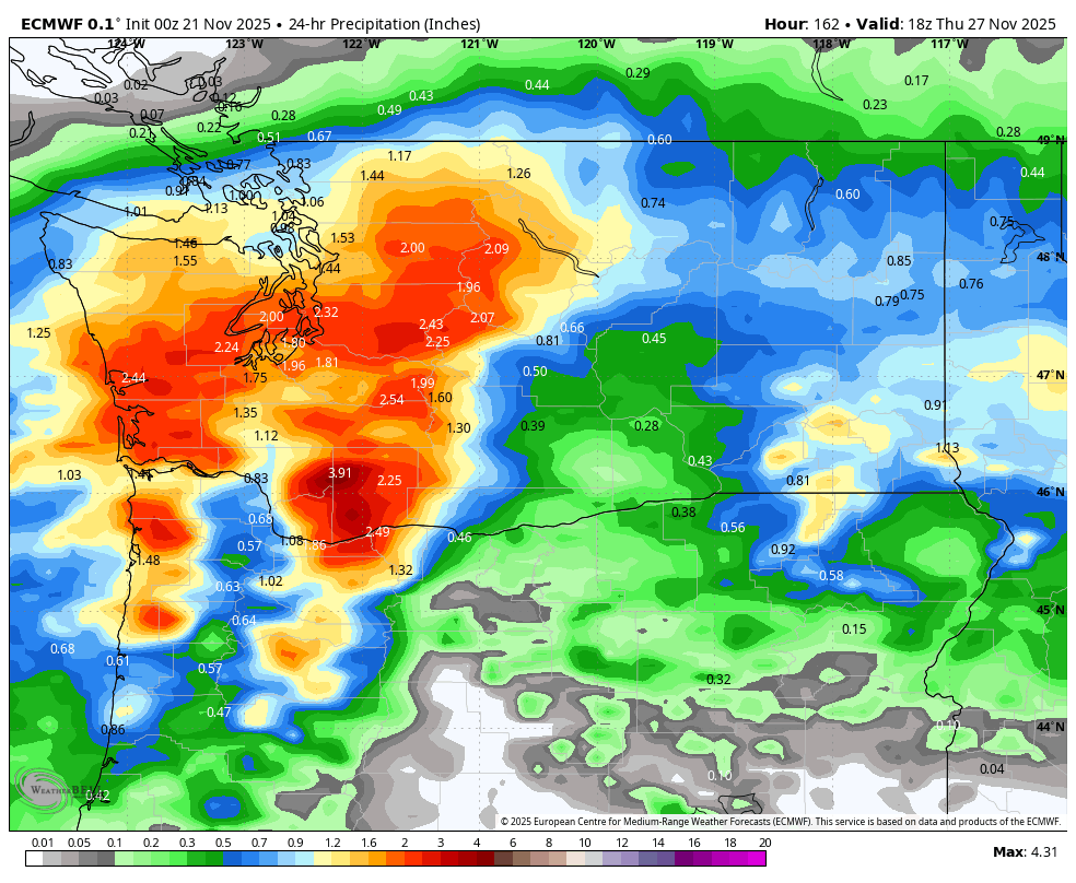
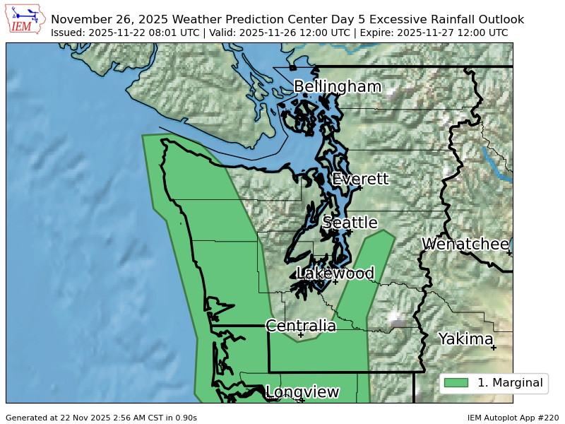
NOAA’s Weather Prediction Center has now even issued a Level 1 out of 4 risk of excessive rain for Wednesday/early Thursday for parts of Western Washington.
3) The storm is a bit cooler than the ones that have preceded it, and this one looks like It could bring moderate to heavy snows in the Cascade passes. We’re still uncertain on the timing and amounts — snow could start as early as later Tuesday but more likely Wednesday and hang into Thursday.

This is probably the most impactful part of the Thanksgiving weekend forecast that will bear watching. (Bears: “DON’T *EVEN* THINK ABOUT IT”… I mean: “RAWR!”) If your travel is local to Western Washington or on a flight, should be OK, just wet.
WHAT ABOUT ALL THIS COLD AIR I’VE BEEN HEARING ABOUT?!?
The long range models are starting to grab onto a more consistent signal for a colder pattern now arriving during the second half of Thanksgiving weekend. The Wednesday-Thursday storm will push off to the east Thursday night, ushering in cold air behind it.
The forecast is trending dry Friday through Sunday but increasingly colder. It’s not at this point looking super-DUPER cold, but definitely chilly with highs only in the low 40s and lows in the 20s to low 30s — our best chances of our first freezes of the year. Ducks may be safe on Thursday, but Husky Stadium could be a raw, chilly, breezy but dry Saturday as UW works to get its Thanksgiving weekend Ducks in a row.

The cold air looks to last through at least the first week in December. Precipitation-wise, there’s not a lot as we get into a drier flow, but there are a few weak systems drifting in from the north at times that could bring a little snow to Eastern Washington and the mountains.
Here in the west, it looks like chilly light showers at times; maybe some fringey flakes in the higher elevations but we’re looking way out into the future. Long range model accuracy is better but 10+ day forecasts still aren’t what they’re quacked up to be.
Great job Scott love the blog