What would a ‘Super’ El Niño mean for Seattle and the Pacific Northwest?
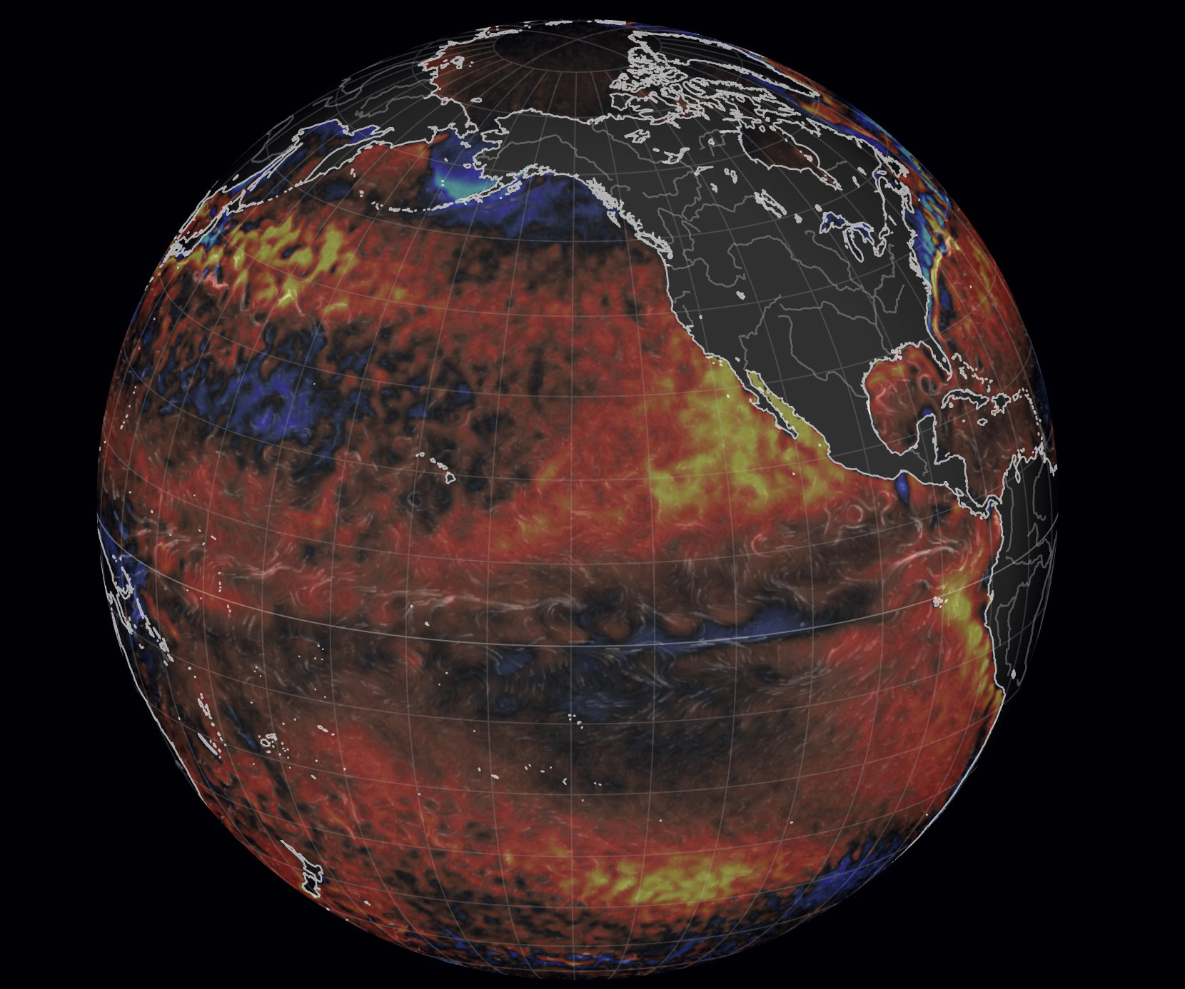
Current SST Anomaly (Via Null.EarthSchool.Net)
OH, LOOK! IT’S ANOTHER SUPER EL NIÑO POST! 😮
I’m sure if you’re someone who follows the weather on the internet — and guessing if you’re reading my weather blog, you are — your browser has likely been full of posts talking about a SUPER EL NINO coming later this year.
Well, here is one more!
I figured I’ve give my take on this budding event focused on what it might mean for Seattle and the Northwest, FAQ style.
IS THIS SOME NEW MADE UP WEATHER TERM TO GET CLICKS?
NO! Well, kinda no…
(OK, so… maybe.😂)
“El Niño” has been around for decades. It’s the paired cycle with La Niña, only this time the water temperatures in the tropics of the central Pacific Ocean are above average. La Niña is when they’re below. (“Neutral” or, informally, “La Nada” is when they’re close to average).
We’ve been in La Niña the past few winters but just Thursday, NOAA declared La Niña as La Muerta. (WARNING: I took French in school — and a lot of good that has done for me besides being able to sometimes read food packaging twice while in Vancouver, so I’m hoping I’ve got the Spanish right. If not, Say La Vee*. (Second warning: I wasn’t very good in French…)
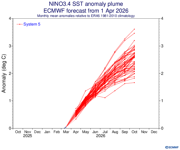
So now we’re officially in the “neutral” phase, but several of the forecast models that we use for predicting such El Nino-ey things are not only adamant that we’ll rocket right into the warm El Niño phase soon, but perhaps reach strong to even “super” El Niño strength — or even, dare we say, record strength, if the latest European models are on the right track.
An El Niño is considered “strong” if the waters warm to between +1.5 to +2.0 Celsius (+2.7 to +3.6 degrees F) above average.
While there is no official weather term for when El Nino warms beyond 2.0 C besides “very strong”, we in the media have happily filled the gap, now running with “Super El Niño” for those type of events. NOAA, for its part, says don’t blame them, they didn’t come up with that. (“Polar Vortex” and “Atmospheric River” though…)
The all-time record El Niño (data back to 1950) on the recently adjusted “RONI” scale (don’t ask) is +2.5 set in 1982-83, with +2.4 reached in the infamous El Niño winters of 1997-98 and 2015-16. (You might recall the winter of 2015-16 was given the nickname “Godzilla El Niño” by some.)
The raw Euro model suggests there is a decent chance of getting close, or even exceeding +3.0 C!
3.0?!?! IS THAT A SUPER…. *DUPER* EL NINO?
Ummm… sure. Dibs on the TM though.
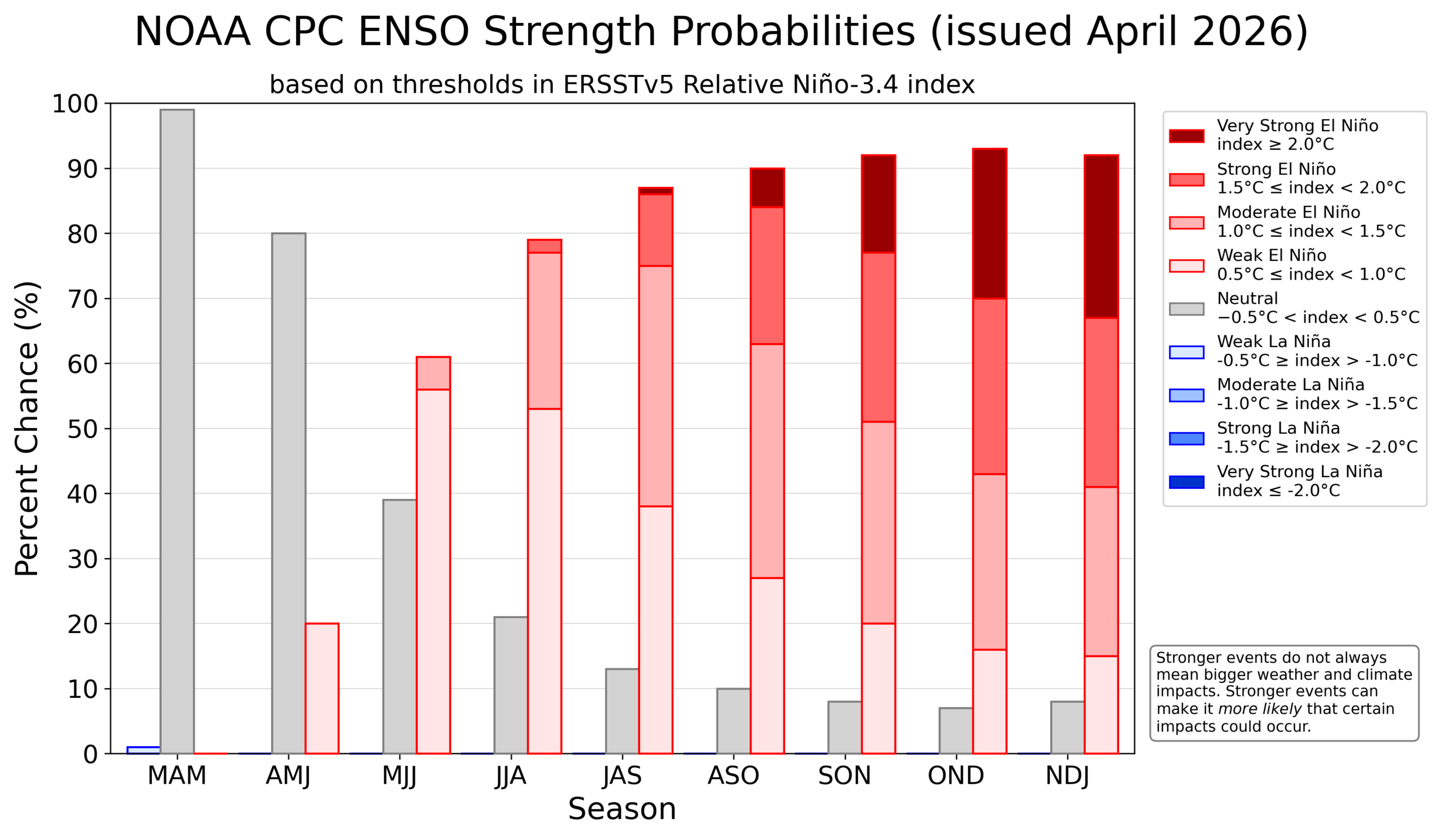
FWIW, the human forecasters at NOAA have so far instead only given a 25% chance of El Niño going into “super” mode, but overall a 92% chance of El Niño and 77% chance of it reaching at least moderate stage (<+1.0 C).
SO WHAT DOES A SUPER DUPER EL NINO MEAN FOR ME?
El Nino’s usually don’t have much summer or early autumn impact in the Northwest, saving its impacts for late fall and winter.
But in the general sense, an El Nino fall and winter is usually not good news for the Pacific Northwest, unless you’re one of those weirdos (and I mean that in the most loving way possible) who want winter cancelled and like mowing their lawn in early February.
Most El Niño winters play out by shifting the storm track well to the south into California, soaking them with frequent torrential rains but leaving the Pacific Northwest high (as in temperatures) and dry.
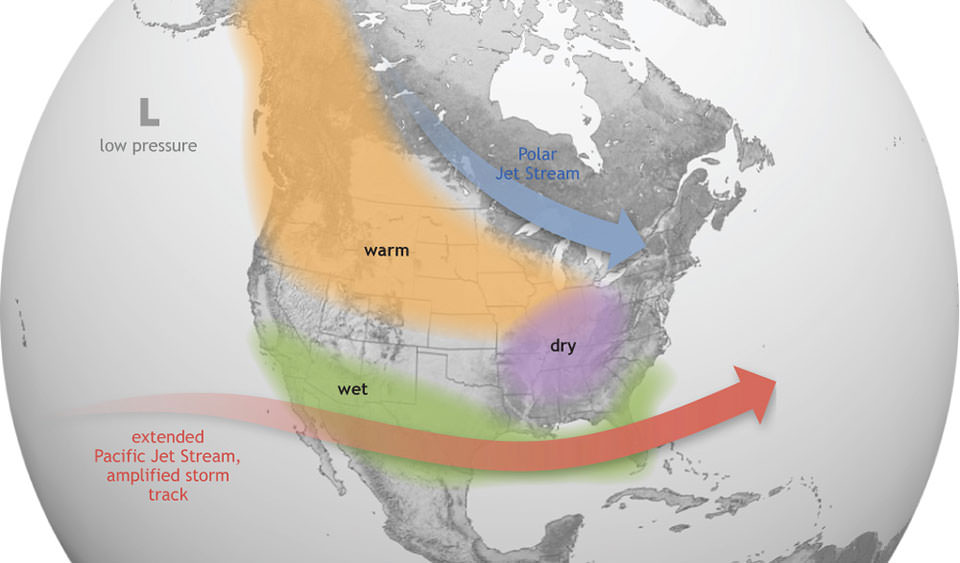
While there certainly can be brief periods of un-El-Nino-ey winter (it can still snow during an El Niño winter! Just…not as likely), overall we’d expect below-average rainfall and snowpack and much warmer than average temperatures — though the warm signal seems more reliable than the dry signal.
On average, strong El Ninos have ended up with snowpack in the Washington Cascades at about 75% of normal.
IS THAT A SUPER SLAM DUNK?
No! And there is your morsel of hope. You can look all the way back to… just this past winter for examples of when the El Niño/La Niña prophecies failed. We just came out of a weak La Niña winter that would usually portend a decent winter snowpack… or at least not one so far below average. So that test case failed in spectacular fashion.
MORE: Seattle finishes warmest La Nina winter on record
Of course, going past +2.5C would be literally uncharted territory and so there could be surprises. But even those past “Super” El Niño years, while still ending up below average for snowpack, were not “super” far below average. This chart here shows all the snows at Snoqualmie/Hyak, color coded for La Nina vs El Nino. (The record low snowpack of 2014-15 winter was more influenced by the “Blob” — a massive and persistent patch of very warm waters just off the Pacific Northwest coast that kept us very warm through the winter.)
But a mild winter is still the heavy favorite — more so than a typical El Niño year, I’d say. Underdogs still win, but I’d put this at like a 14 seed beating a 3 seed for winter to not end up warm/dry, for those of you missing the basketball brackets already. And I agree that coming off this winter that failed to live up to its billing, it would not be the best scenario :/.
And elsewhere, it could be mayhem. Just on the west coast, the strong El Niño of 1997-98 brought massive flooding to California — Santa Barbara got over 21 inches of rain just in February. From what I remember, many of the storms were so geographically large that we were making up for not getting the brunt of storms by still getting some rainfall from the northern fringes of the California storms. Globally, the World Meteorological Organization estimated $32 billion to $96 billion in economic losses from El Niño-fueled weather impacts that year.
El Niños — particularly strong ones — also release a lot of heat into the atmosphere with the warm waters and extra sunshine making the globe more prone to heat events and likely going to push 2026 and perhaps even 2027 into hottest years on record.
THE REST OF MY FEED IS TALKING ABOUT A NEW HURRICANE FORECAST OUT TODAY?
Yes! El Niños — particularly strong ones — tend to suppress hurricane activity in the Atlantic Ocean basin but supercharge the season in the Pacific by warming waters and weakening wind shear.
But despite that, I am bucking the national trend and calling for an average hurricane season in the Pacific Northwest of 0.0 storms 😉. Still, 0.0 storms would still place this season in a 100+ year tie for most active seasons on record around here!
(The Pacific Northwest has never had a landfalling tropical storm, nor within like 1,000 miles. Baja California is about as far north as they can go, though there appear to be three historical cases of a tropical storm or remnants reaching extreme southern California.)
DO I HAVE TO WORRY ABOUT EL NINO THIS WEEKEND?
No! It’s sunny again Friday with temps in the upper 60s(!). But a storm moving into California will spin some showers up our way on Saturday and maybe even a few thunderstorms with temps dropping into the 50s. Next week looks much cooler and occasionally rainy with highs in the low-mid 50s.
Ironically, next week end up more “wintry” than some of our actual weeks this winter!
DO I NEED TO WORRY ABOUT ANYTHING ELSE THAT’S ‘SUPER’?
Not unless your name is Bowser and you’ve got a princess stashed somewhere.
(*- Yes, I know it’s “C’est La Vie” — I got a C, not an F 😂)