Seattle may face heat, smoke, then remnants of Tropical Storm Elida?
 Scott Sistek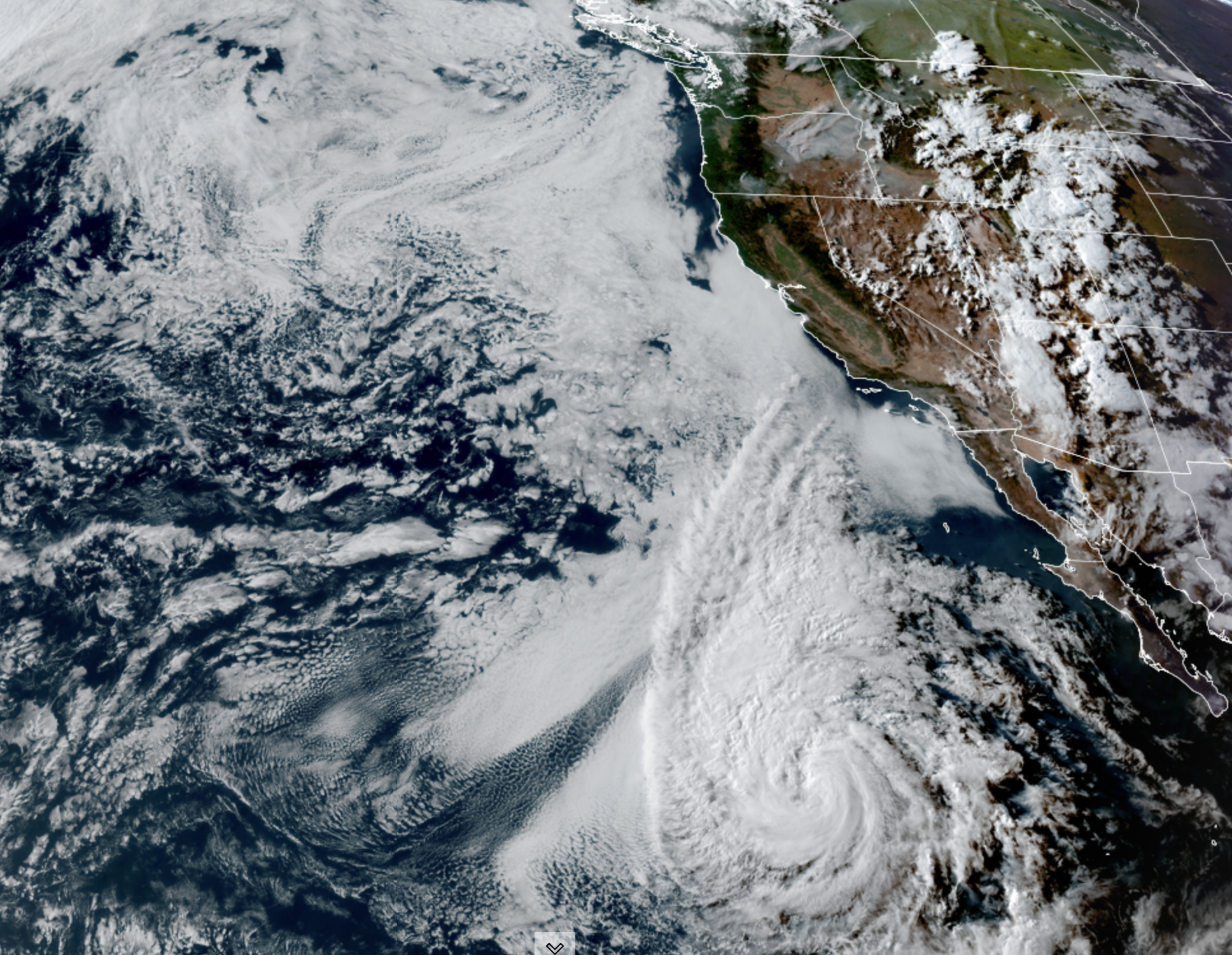
GOES 18 Satellite image showing Tropical Storm Elida of the Mexico coast (NOAA / CIRA/ RAAM-B)
(TL;DR: About to get pretty hot in Seattle next week with 90s likely Tuesday and Wednesday. Then maybe some smoke moves in, and then possibly some thunderstorms from a former tropical storm (!!) later in the week.)
“I’ve got good news and bad news, which do you want first?”
“How about the good news?”
“I lied. I only said that to make you feel better…”
The forecast this week has three main features, and none of them I’d say are eagerly awaited. First up, it’s going to get hot, then it might get smoky for some, and THEN it seems we could attempt a repeat of last Thursday’s thunderstorms, thanks to the remnants of a tropical storm. Oy. This just might warrant Emergency Kittens?
We’re in the middle of a warming trend now as high pressure pushes into the region. I guess if you need a morsel of good news is that Sunday will end up also pretty comfortable as Saturday was — some variable morning marine clouds that will burn off quickly and lead to a sunny day with highs a bit warmer into the upper 70s and low 80s.
As upper level winds shift to the north, the heat keeps building on Monday where we should reach the mid-upper 80s in Seattle. But with the heat comes another unwanted guest: Wildfire smoke.
Western Washington is finding itself in an unenviable position as some past summers where we have wildfires burning to our north (in Canada), east (in Eastern Washington) and southeast (in eastern Oregon.) That’s a large swath of the compass that if the wind blows from that direction, it’s going to push smoke our way.
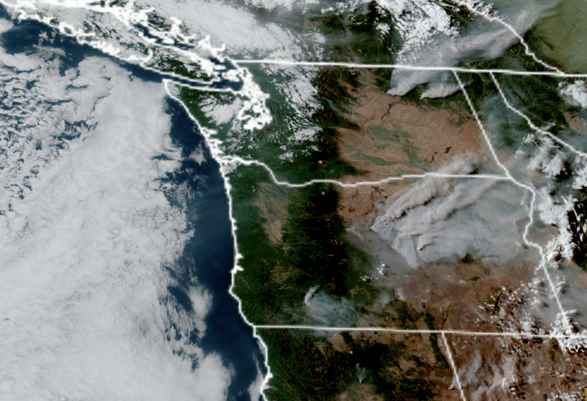
The good news (Hey, found some more!) is that a majority of the time, the winds here blow off the Pacific Ocean which, as of this writing, isn’t literally on fire. (Metaphorically though with the budding Super El Niño?). The marine breezes not only act as a natural air conditioner, but also keep the smoke away (most of the time). But when we get hot, it means a wind shift and wind shifts are not what we want in this situation.
So in this case with a north wind, the smoke models indicate some smoke will move from Canada into northwestern Washington, covering the northern Olympic Peninsula and from about the Seattle/Puget Sound area north through the border. (Smoke in Eastern WA, southern B.C. and Vancouver Island too…)
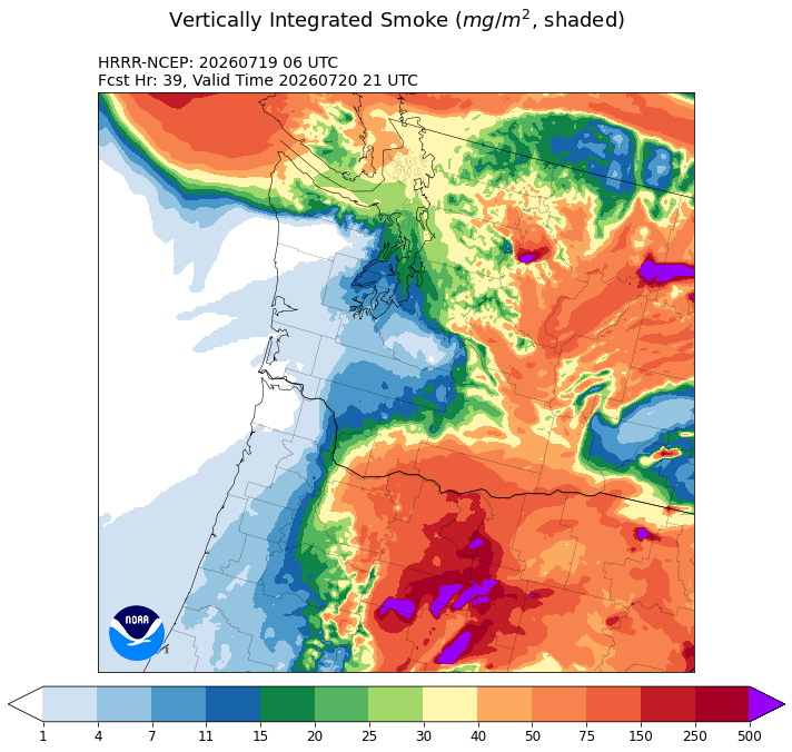
The coast, and Southwestern Washington from about Olympia south looks like the place to be to avoid the smoke — at least as of now. Double bonus with the coast where it’ll be cooler.
It doesn’t look like thick, dense, surface smoke so far — more of a haze, but may reach toward the surface. So heat + air quality may be a concern and make it a very difficult choice whether to keep window open for cooling or closed to keep out the smoke 🙁
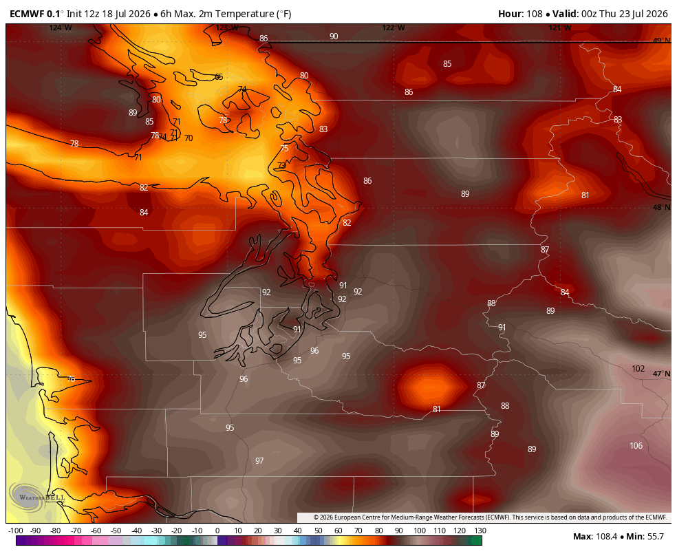
The choice gets more difficult Tuesday and Wednesday as temperatures climb to around the low 90s in Seattle and go even hotter away from the water. The smoke will likely be around through then but may thin a little.
HOW COULD THIS GET ANY WEIRDER? LET’S TOSS IN A TROPICAL STORM
OK so first, it’s not like a tropical storm is actually coming to the Northwest. But we *might* trade the heat and smoke for another round of thunderstorms later in the week if some forecast models are on the right track. How?
If you look at the satellite image here, you’ll see Tropical Storm Elida spinning off Mexico’s Baja California coast. But forecast models indicate this storm will eventually move due north well off the U.S.’s Not-Baja California coast. The storm will eventually hit our cold Pacific Ocean waters (the waters are warm but aren’t THAT hot…) and fizzle out of tropical storm status to just a remnant low, but some models show that the remnants will keep spinning their way north offshore — and perhaps close enough to spin some moisture and convection our way into the Northwest.
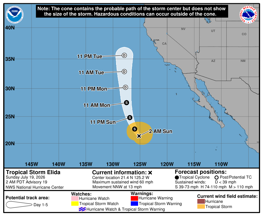
This is sort of the playbook that happened last Thursday with our thunderstorms (minus the “tropical storm” remnants part) and so depending on how close those remnants get to us, we could see a repeat performance of some thunderstorms on Thursday.
This is still very low confidence and highly uncertain at this point, but something we’re watching. The good news is it would break the heat wave and cool us off, and flip the winds around to push the smoke back. So we may trade heat and smoke for cooling and thunder.
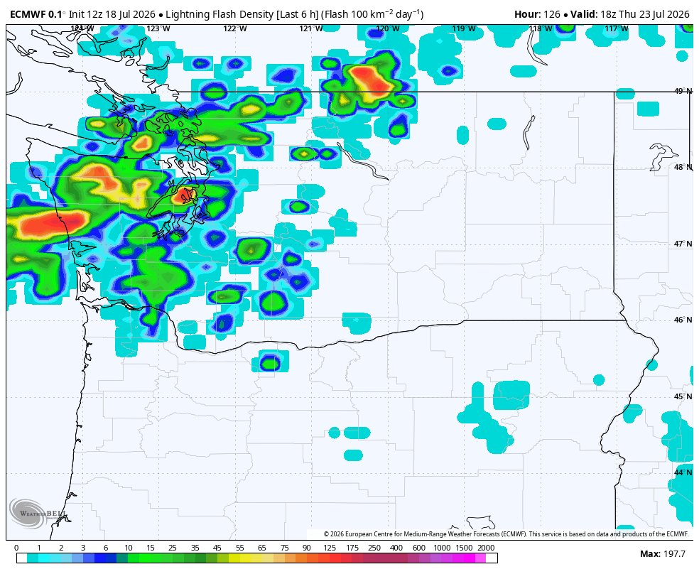
But lightning is the last thing we need with all the wildfires already burning around here :/
The long range models do show once we get past Thursday’s mayhem we may be more “Seattle summer normal” with highs in the 70s next weekend.
“HMPH. YOU GOTTA FIND AT LEAST *SOME* GOOD NEWS FOR US COOL WEATHER FANS TO FEEL BETTER…”
OK, I dug deep and found some morsels of good news:
- Sunsets just came back inside 9 p.m. in Seattle a few days ago. No more 9 p.m. sunsets until next summer!
- We’re about to pass one month since summer solstice. Fall is 60-ish days away!
- From the “it could be worse” dept.: Some places in the Northeast on Saturday simultaneously had a Tornado Watch, Heat Advisory for 100+ heat index, Flood Watch and Air Quality alert for hazardous amounts of wildfire smoke.
- Super long range models are hinting at maybe some cooler weather again toward the end of the month.
AND…EMERGENCY KITTENS?
Yeah, I think this qualifies.