Coastal flooding, windy weather on tap as storms land 1-2 punch against Pacific NW
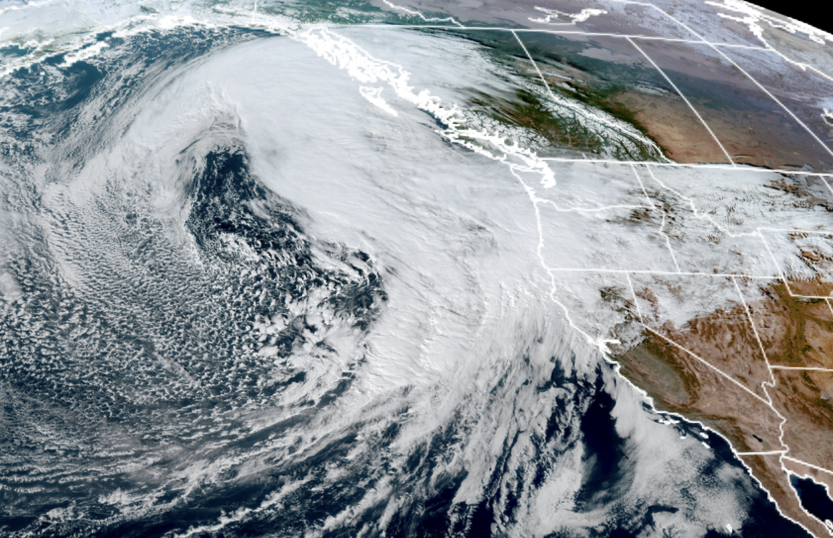
GOES 18 Satellite Image for Nov. 4, 2025.
The forecast for this week has become a little… challenging — at least in the communications realm.
The Pacific Northwest is staring down back-to-back storms coming in a quick 1-2 punch this week, promising flooding for some areas, strong winds for others — but probably also confused shrugs of “what was all the fuss?” for, oh, just a few million in the city.
There’s various impactful weather events on the horizon for areas to the west, north, east and south of Seattle. But for the main urban Puget Sound core area, the forecast can be summed up pretty quickly: Break Tuesday, wet and blustery Wednesday and Thursday, drying Friday, and perhaps a dry weekend (!).
There’s your unintentional TL;DR segment, folks! Seattle folks can safely click over to Seahawks trade deadline news in your feed if in a hurry. See you tomorrow!
But since you’re probably only two sips into your coffee by now (unless you’re like me and are like: “What? I’m already halfway through my second cup…”) if you want more weather info (there’s lots!) join me as I dive into the other weather issues at hand.
I HAVE A WHOLE POT OF COFFEE HERE AND AM PREPARED TO BRAVE PAST TL; DR. WHATCHA GOT? (SIP…)
Let’s start with Tuesday which will for just about all of us be a break from the stormy weather — maybe even a little sun around the edges at times. However a deep low pressure center that is anchoring the “Storm 1” of the 1-2 punch for Wednesday is going to roll by well offshore today on its journey north.
As it passes due west of us, it will create a few hours of gusty east winds in the Cascade passes – for the usual windy spots like North Bend, Emumclaw, Gold Bar, Black Diamond. A low-end Wind Advisory is in effect there from Tuesday evening through the night for gusts of 40-45 mph.
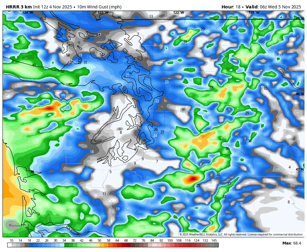
The low center isn’t very deep and we don’t have the cold air in Eastern Washington to enhance the higher pressure to the east so we’re not expecting any major winds, just noticeable. Winds will quickly ease Wednesday morning as the low goes farther north.
For Wednesday and Thursday, our greatest attention turns to our friends on the coast, where moderate to even major coastal flooding is looking likely.
WHAT’S CAUSING THE COASTAL FLOODING? (SIP…)
The eastern Pacific Ocean remains a cauldron of bustling activity with a very strong jet stream, loads of tropical moisture and multiple deep low pressure centers swirling around out there. Aside from peppering us with storms and fronts from all those weather systems, all that activity is churning up the water and creating large, pounding surf along much of the West Coast.
Add to that we’re entering a period of astronomical high tides with the close alignment of the sun and moon AND the lower atmospheric pressure adds even more height to waters (think of the atmosphere, when in lower pressure situations, applying a gentle “suck on a straw” effect on the water levels to pull them a little higher.)
So heavy surf + high astronomical tides + high tide + low atmospheric pressure equals a recipe for coastal flooding.
Coastal Flood Warnings are in effect from Wednesday morning through Thursday evening for the northern Washington coast and Grays Harbor County Coastal areas. Right now, projections are as much as sea water reaching 2-3 feet above ground level, especially during the midday high tides on both days.
Wednesday’s tides are higher but the surf is a little lower to start — about 10-14 feet. Thursday’s tides are slightly lower, but the surf is expected to increase to 14-17 feet making Thursday even more ripe for impacts. Those around Westport know this drill but be ready for flooding along the coast.
NWS Seattle says “there is high confidence in the water levels reaching moderate to major flood inundations coincident with the midday high tides, particularly in Westport and La Push. Wave activity is expected to peak on Thursday, potentially resulting in as many or more impacts than the high tide on Wednesday.”
Elsewhere Wednesday, it’s mostly just a rainy day, a little blustery with east winds dying down early in the morning and non-impactful breezes elsewhere. The wrath of this storm is still focused on southern Oregon and Northern California where much heavier rain and stronger winds await.
OK THAT WAS A LOT AND I SEE THERE’S MORE… AM I GONNA NEED A SECOND POT? (SIP…)
Maybe try switching to decaf because we’ve still got Thursday to wade through…
The second storm – technically an atmospheric river storm but on the lighter side — will still be rainier and windier for Western Washington Thursday as the jet stream takes closer aim here. But for the core Seattle Metro/Puget Sound area this is just another rainy and blustery day.
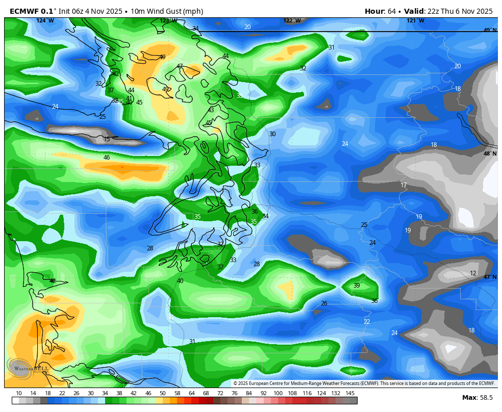
The strongest winds look to stay confined to the coast and Northwest Interior — they’ll probably get some Wind Advisories out of this for gusts of 45-50 mph, but no different than the windy days of the last few storms up and over there.
It does look like it’ll be enough rain in the Olympics to send the Skokomish River over its banks. Shocker, I know.
So if you’re scoring at home that is:
* Gusty east winds for Cascade foothills late Tuesday into Tuesday night (Wind Advisory; 45 mph gusts)
* Coastal flooding likely Wednesday and Thursday
* 40-50 mph wind gusts likely Thursday along coast and NW Interior
* Skokomish River may flood (again) Thursday into the weekend.
* Rainy, blustery in Seattle area Wednesday/Thursday and…. that’s about it.
WHAT ABOUT THE WEEKEND? HOPE IT’S SHORT THE CAFFEINNE IZ GETTONG TOO MEE
Short and sweet: Drying Friday, still looks dry Saturday and most, if not all of Sunday! Wow! Also: Don’t ask about next week!
OK I AM UP TO SPEED, TOTALLY CAFFEINATED AND…NOW JUST REALIZING I AM 20 MINUTES LATE FOR WORK
But at least you’re informed! Send this to your boss as an excuse and if so daring, ask if they’ll subscribe: