Weird weather: Seattle faces rain, wind and near-record heat as Friday the 13th week kicks off
 Scott Sistek
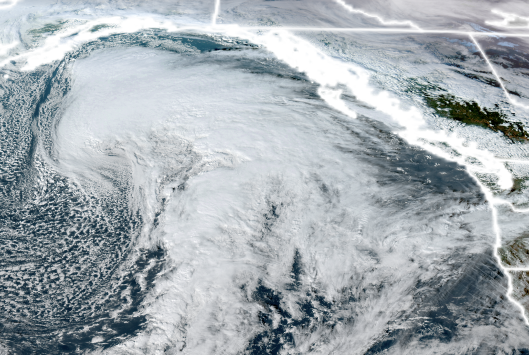
GOES-18 satellite image showing the first of several potent storms in the northern Pacific Ocean on Nov. 8, 2026. This one is heading into Anchorage but the front will stretch over 1,500 miles along the West Coast. (NOAA / CIRA / RAAM-B)
There’s some rather oddball features in the weather this week around Seattle and the Northwest, from storms that aren’t too windy, to storms that are kinda windy, to maybe a storm that gets pretty windy, mixed in with some potentially record heat along the way…
If there was ever a week of weather befitting a Friday the 13th, this just might be it…
The weather pattern is VERY active in the Northern Pacific Ocean, but luckily for us, it’s *too* far north to bring severe wind storms down here.
To begin the week, there are two very deep and strong low pressure centers that are rolling across the Gulf of Alaska Monday and Tuesday. Geographically speaking, both are going to be HUGE, but they are going to make landfall far, far away.
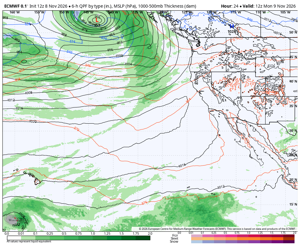
Monday’s storm center is heading for Anchorage, Alaska, but it will spawn a cold front that will stretch the entire Alaska Panhandle, British Columbia Coast, Pacific Northwest coast, and even down to about Crescent City, California — roughly 1,700 miles.
That will bring rain into our neck of the woods Monday afternoon into Monday night, but with the front stretched out so far, it’ll just be some routine Seattle rain and blustery-but-not-severe winds (a little gustier on the coast since they are still exposed to the pressure gradient even with a distant low, but not as windy as Saturday.)
Weird Factor: 6 — Anchorage, Seattle and California share a storm?
A second storm is right on the heels of Monday’s to where it may be difficult to discern the break between the two, especially since it looks like the break will come in the middle of the night Tuesday morning.
This storm is about the same strength for a low pressure center, but coming inland slightly closer — like the Alaska Panhandle. However, this one those is going to aim more of an atmospheric river-type plume into B.C. and northwestern Washington.
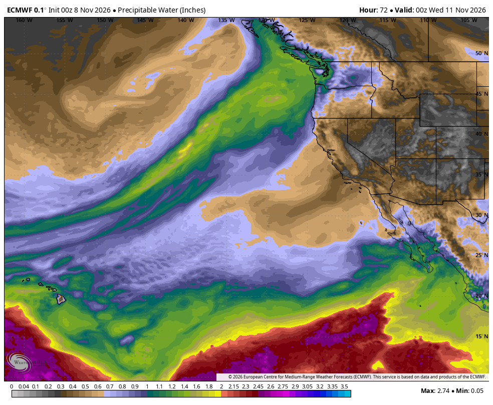
So it’ll be wetter and a little windier for the coast and Northwest Interior with some gusts to 45 mph — though the Seattle/Puget Sound area won’t see much besides a breezy day.
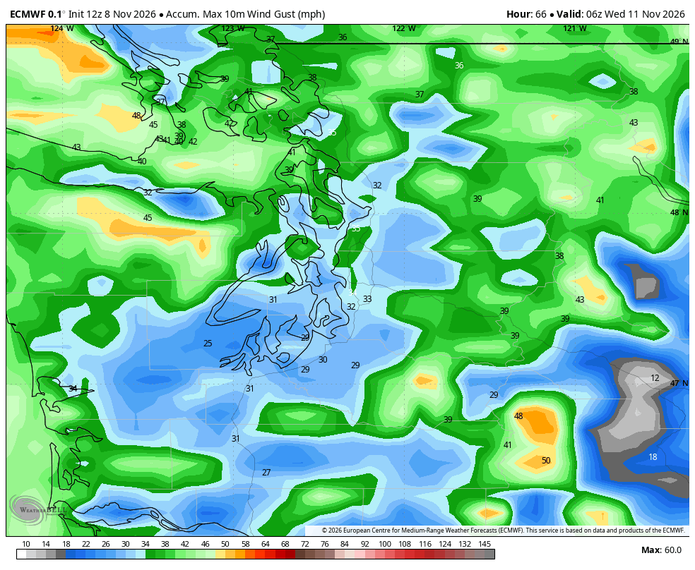
So wet and windy again Tuesday, but not extreme amounts of either.
Weird Factor: 5.5 — only because it’s so close to the other one and has a long front again. And we get to say “atmospheric river.”
Tuesday’s AR rains fade by dawn Wednesday morning (or for those of you in British Columbia, dawn…plus an hour 😉 ) The next storm system start to spin up offshore on Wednesday, but this one begins to weaken and as it gets pulled north, the front is going to stall well off the coast and start to shred a bit.
Much like what happened Saturday, this will instead spend the day “pulling” up warm air from the south like a magnet as the storm swirls and the front spins off the coast. If you enjoyed Saturday’s “freaky” warmth, here’s another chance on Wednesday, only without the soaking rain and power outages hours later.
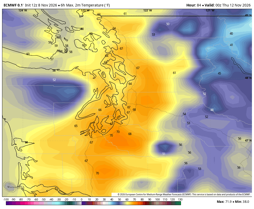
It’s actually timing out not just the warmest, but driest day of the week — and right on a holiday, so that’s weird in itself. But even weirder? It might be *record* heat. Seattle’s predicted high at the moment is 64 degrees for Wednesday and the record is 65 set in 1990. Seattle “only” reached 62 on Saturday at Sea-Tac but many other places in the Puget Sound area reached the mid-upper 60s. (Hey remember like just a couple months ago we’d all be freezing at the notion of 62 degrees?)
So to get one record warm day is weird enough. Getting a second in the same week from a *different* meteorological event is very weird. (Doing it the week of Friday the 13th? :O )
Weird Factor: 9.5. I suppose if it somehow snowed too it’d get the full 10.
Thursday’s looking cloudier and a little rainy as what’s left of that splitting front finally staggers ashore.
Weird factor: 2.0
Then Friday the 13th into the weekend is looking… questionably stormy. The long range models are pretty much in agreement it’s going to be a bit stormy again, but lots of disagreements on which is the stormiest day between Friday, Saturday or Sunday (leaning more the weekend at the moment).
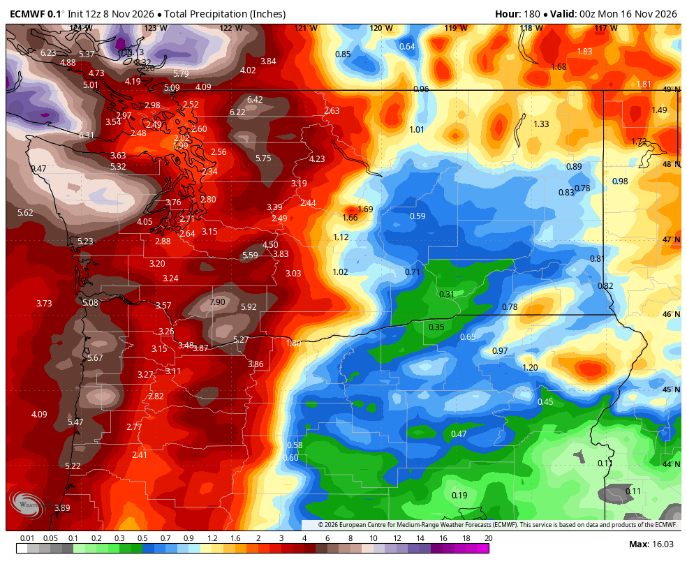
The pattern they are hinting at is conducive to more traditional stronger storms where we have a low pressure come make landfall closer to home and we all get windy for a while. But right now they haven’t really homed in on any particular storm to actually *do* that yet.
So it’s like the door is open, but will any storm come inside? We’ll keep an eye on it. Right now the answer is a tenuous “no” though I would bet on it at least being rainy and breezy at minimum over the weekend.
But one thing it likely won’t be is snowy in the mountains. None of the storms this week are cool enough for pass level snow.
Weird factor: 6.5: Will it or won’t it storm on a November weekend in Seattle when we’re getting a warm dry day on a midweek holiday, plus the Friday the 13th “Weirdness” Bonus.
(Also, side note: This Friday will be the 45th anniversary of the historic Friday the 13th storm of 1981 that slammed into Oregon and Washington…and the storm that as a kid living on the Oregon Coast at the time, is “that storm” that got me into weather, especially when your Dad was in the Coast Guard. I’ve blogged about this storm extensively in the past, but this storm is usually mentioned in the Top 5 worst windstorms to strike the Northwest, and you could argue a case for Top 3 behind the Columbus Day storm in 1962 and the Hanukkah Eve storm of December 2006.)