Rain is coming to Seattle this week. Then it gets complicated.
 Scott Sistek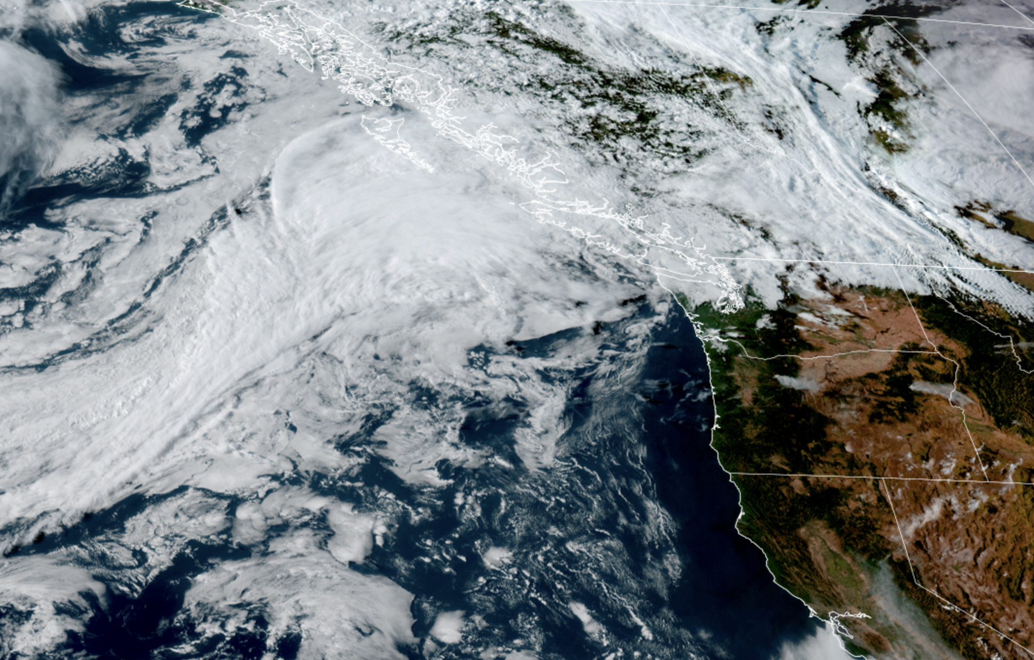
GOES 18 satellite image from Aug. 30, 2026. (NOAA / CIRA/ RAAM-B)
It’s a very strange week for Seattle meteorologists trying to get a good feel on the forecast, which features a weather pattern that is both a slam dunk and yet has maddening uncertainty.
(Then again, we’re heading into a holiday weekend, so I would expect nothing less…)
THE SLAM DUNK PART: IT’S GOING TO RAIN. EVERYWHERE*. FINALLY.
(*Everywhere like, in our region. Not like the entire planet…or any other planet. Even for you too, Pluto: Labor Day weekend looks dry! Just, not very sunny!)
You’ve got two more days to soak up the last morsels of summer vacation with some semblance of summer weather. Both Monday and Tuesday will be dry and comfortably warm in the mid 70s.
But a strong (for early September) low pressure system will glide down from the Gulf of Alaska and along the B.C. Coast Tuesday, sending some clouds out ahead of it. First they’ll arrive into Western Washington as Tuesday progresses, then showers will develop Tuesday night as an opening salvo.
On Wednesday, the storm center will swirl off the coast where it will spin a cold front through the region.
The “slam dunk” part of the forecast is that the front will bring widespread light to moderate rainfall across Western Washington (aka, “everywhere”) for a chunk of the day.
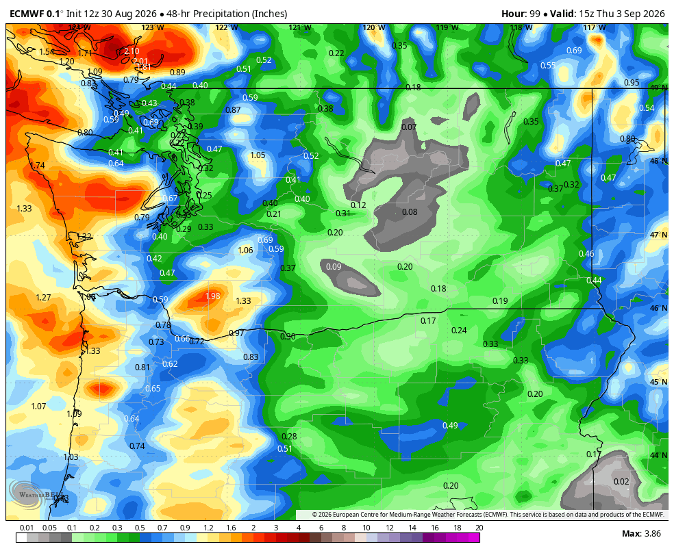
This isn’t like the hit-and-miss showers we’ve had of the summer so far. This will be: The radar looks like someone spilled green and yellow paint across the landscape and the ducks (LOWERCASE “d”!!) will be happy**.
(**-As a UW alum, how do we petition the Doppler radar folks to use purple instead?!?)
By the time the front passes, everyone will have had a nice, wetting rain. It’ll be a bit breezy too, with gusts generally 30-35 mph — maybe 40+ in the Northwest Interior. So rainy, cool and breezy but not a significant amount of any of the three — a true autumn sampler, but not a main dish.
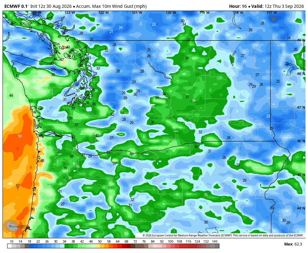
And yes, even the Cascades and Eastern Washington are expecting a nice wetting rain out of this. First time the weather will really be an assist to those battling the wildfires!
NOW COMES THE HARD PART…
What isn’t a slam dunk is the timing… or what comes next. The forecast models — even with the event pretty close — seem unsure if the front will arrive during Wednesday morning into midday, or if it’ll be more of an afternoon/evening/night deal.
Get used to the uncertainty, it’ll be a theme.
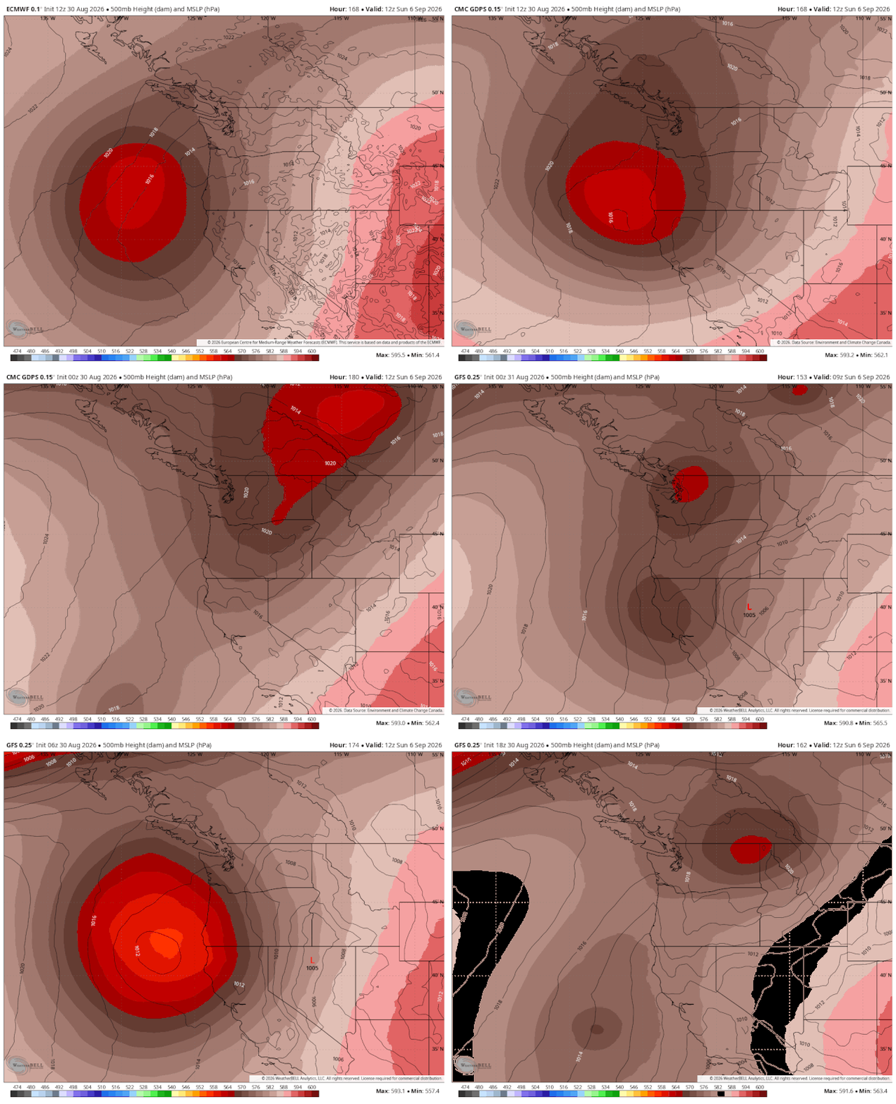
Because after that front passes, all the forecast models are having a VERY difficult time deciding what happens next to the low pressure center.
The wetter scenario is that the low hangs out just offshore until Thursday, then turns and spends Thursday, Friday and maybe even Saturday staggering inland across Washington.
That would push us back into the hit-and-miss showers routine as the low destabilizes the atmosphere. But this time, there would be plenty of showers and some of them heavy at times, with even a chance of a few rumbles of thunder (especially in the mountains.) And also— sun breaks! But generally while not steady, widespread rains, it would keep a cool and wet theme going into the start of the holiday weekend.
(Those kind of showers would also reintroduce the risk of scattered lightning in central and eastern Washington though :/ )
The drier model runs show the low instead turning south and moving away from the Northwest — likely still some lingering showers Thursday but generally decreasing showers and mostly dry Friday and Saturday.
There’s several iterations in between with seeming random predictions of when it’ll rain vs. be dry. What’s even more maddening is the models are flip-flopping amongst themselves.
As an illustration: Between the European (“Euro”), American GFS and Canadian models, they have forecast the center of the low and its concentration of rain showers on Sunday morning in the following places over their last few model runs:
- Off Crescent City, California
- Off Astoria, Oregon
- Hood River, Oregon
- Seattle (as part of a double-low)
- Yakima, Washington
- Spokane
- Near Edmonton (Yes, Alberta, Canada — after it cuts across Vancouver Island on Friday)
- Pluto(?) (Well, sorry, now your Labor Day Weekend forecast is in flux too…)
It’s as if all the models got together and said:
Euro model: “Hey look! A storm coming toward the Pacific Northwest. Any of you remember how we deal with these?”
American GFS Model: “Hmmm… it’s been so long, honestly, I was just expecting to just hoist up another ‘smoke and 80’ forecast and call it good. Ask the HRRR?”
HRRR short range model: “You all know while my short range vision is excellent, I’m blind as a bat beyond 36 hours…”
GFS: “Maybe we can just ask our dozens of ensemble model family members what they think?”
Euro: “I already checked and we’d have better luck getting a consensus on what flavor ice cream for the big end of summer retreat.”
Canadian model: “Maybe TikTok can help?”
Suffice to say, plan on scattered showers lingering Thursday through Saturday at this point and be (pleasantly?) surprised if they don’t materialize. Though I’d think we’ll have a better handle on where the low is going before then.
The long range models are just as scrambled with the short term and middle-term uncertainty so they’ve of no help. We are highly confident though it won’t be hot over the next 10 days, at least.
(Also highly confident Pluto is still a planet 😉)
MORE TO EXPLORE:
- Seattle took just 10 minutes to thwart a rain record Saturday
- Sunset and severe thunderstorms spawn spectacular sights Saturday over Vancouver Island
- What are some scenarios a historic ‘Super El Nino’ could present for the Pacific Northwest and California?