As remnants of Tropical Storm Elida loom, why Seattle never gets ‘real’ tropical storms
 Scott Sistek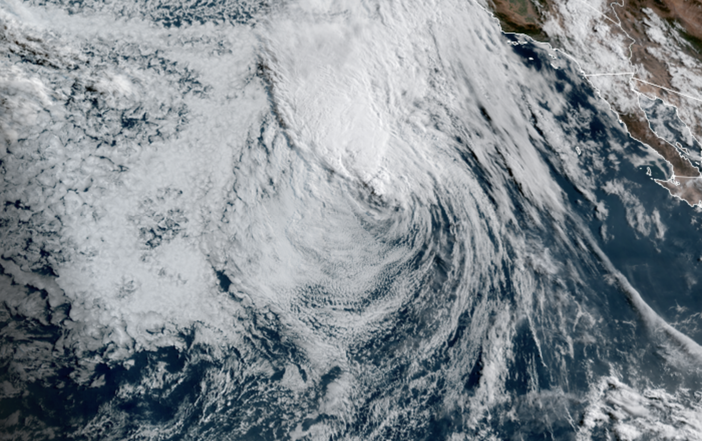
GOES 18 Satellite image showing Post-Tropical Storm Elida of the Mexico coast on July 20, 2026 (NOAA / CIRA/ RAAM-B)
Heat and smoke are still capturing the weather headlines to start this week around Seattle and Pacific Northwest. But for me I’m still intrigued by the possibility on Thursday that we *could* get a few scattered thunderstorms from the remnants of former Tropical Storm Elida.
Elida will be a shell of its current self, which as of Monday morning had just lost official tropical storm status (now a “post-tropical storm”) with 40 mph gusts and was some 1,000 miles off the coast of Mexico’s Baja California. It is, as we say in official weather parlance, “a fish storm.”
The storm is expected to move due north as the week progresses, meandering off the coast of California where, like the bank accounts of hopeful home buyers, it will eventually meet its demise.
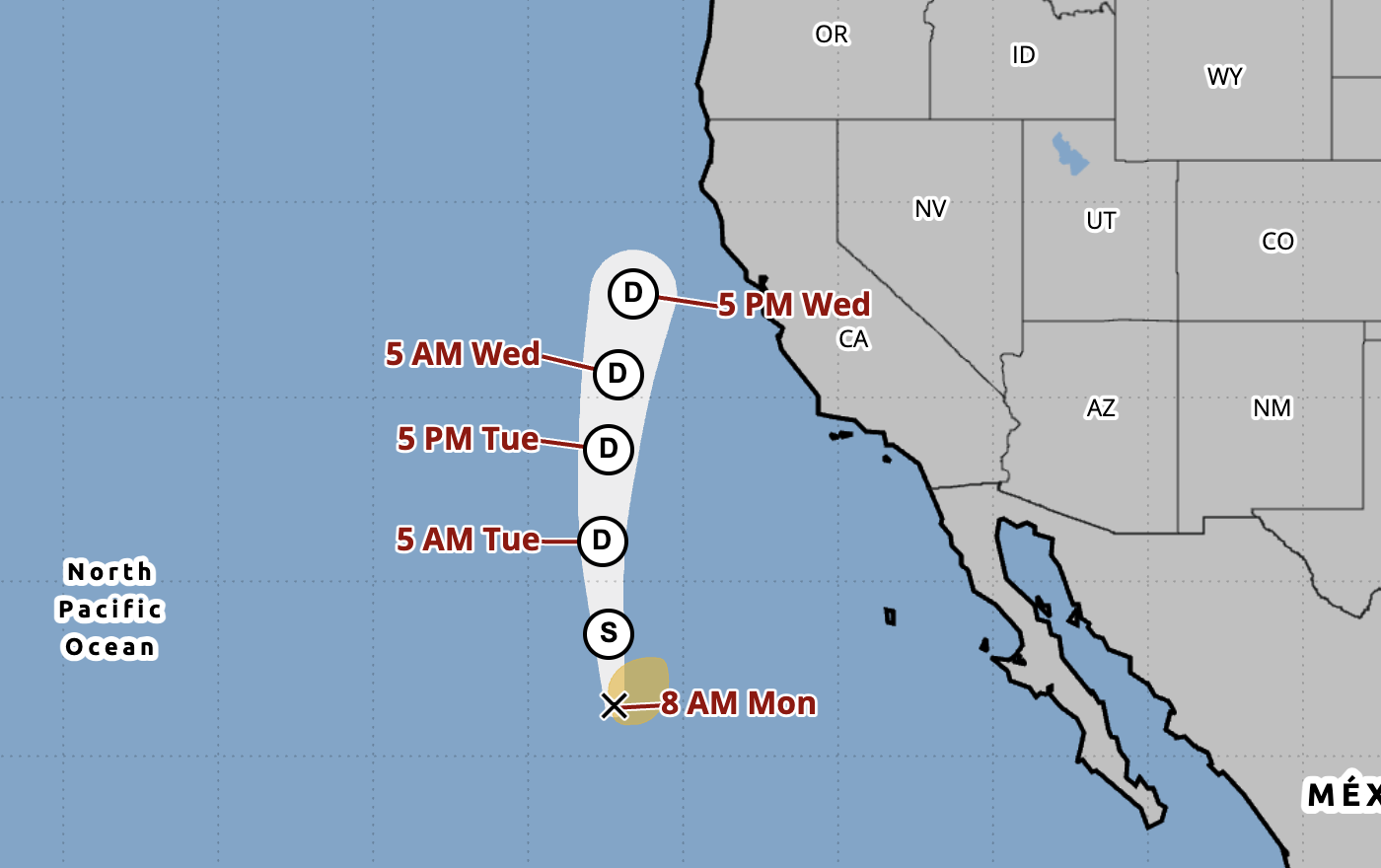
But while the “tropical storm” part of the storm is no more, the remnant low pressure and moisture will continue north along the Pacific Northwest coast, and a mix of forecast models indicate some of that moisture will mix into our heat and could trigger some scattered thunderstorms across Western Washington on Thursday.
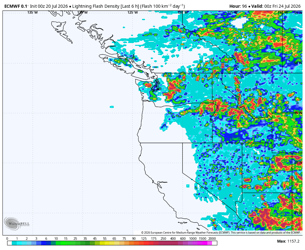
However, it’s also important to point out there are other models that suggest the remnants won’t bring much more than clouds.
WHY COULDN’T ELIDA MAKE IT ALL THE WAY TO SEATTLE?
Quite simply, the ocean water is (still) too cold. Tropical systems need water temperatures of at least about 78 degrees and anyone who’s gone swimming along the coast – even the California coast — knows that the water temps are nowhere near that. They’re usually in the low-mid 50s off the Oregon and Washington coast and low-mid 60s in SoCal. (Also why Seattle and the I-5 corridor have a temperate climate and why thunderstorms and severe weather are rare.)
While the Pacific is running quite warm with respect to average these days, it’s still nowhere within shouting distance of the warmth needed to maintain tropical systems. Thus, it acts as an impenetrable force field against tropical storms and hurricanes ever reaching the Washington or Oregon coast that I think even despite our warming climate, I can safely say it should hold through all our lifetimes. Because getting +25 degrees of ocean warming would take a cataclysmic event…or a really long time to get there. (We’ll see effects of climate change but hurricanes into Seattle won’t be one of them.)
However, as the ocean warms, I could see scenarios where tropical storms can survive to reach Southern California some day. There have been two recorded in history — a likely hurricane that hit San Diego in October of 1858, and a tropical storm that reached Long Beach (near Los Angeles) in 1939. Both those instances appear to have featured a hurricane that formed well south in warmer waters, then raced for Southern California and survived long enough to make it ashore despite weakening in the cooler waters.
(Could it happen again soon? This year with Super El Niño – which aside from warming the waters, weakens the wind shear in the Pacific Ocean and traditionally allows more tropical development — could be a good eventual candidate? We’re already up to the “F” named storm in the Pacific basin, and more storms are percolating, though nothing now suggests this will happen in the immediate future.)
ELIDA’S JOURNEY IS RARE IN OTHER WAYS TOO…
Getting remnants of former tropical systems isn’t exactly unheard of around the Pacific Northwest, but this current path is rare. Usually we get distant ancestral tropical remnants instead. Our most common type is in the fall and winter when moisture and energy from ex-typhoons that swirl in the western Pacific get caught in a robust jet stream and scream across the Pacific, helping fuel new and strong low pressure systems that can bring intense wind and rain storms here.
The Columbus Day Storm was famously tied to the remnants of Typhoon Freda in 1962. There have been others in more recent years that you could trace back to a typhoon heritage. That would be like the typhoon’s ancestry is akin to being our storm’s grandparent.
Sometimes we get distant ancestry of tropical storms or hurricanes that move into western Mexico and its moisture gets caught in the Desert Southwest monsoon conveyor belt. Then you’re tracing a long line of descent from like the Gulf of California through the Desert Southwest and then maybe the upper winds move some moisture back into the Northwest. That would be like the former tropical system was a great-great grandparent — you can see hints of ancestry but it’s quite distant.
Elida coming up the Pacific Coast and still clinging to being a “post-tropical” depression when it’s passing well off the coast of San Francisco is a type of tropical system journey I don’t really remember happening very often. While Elida will be no more, in my ancestry analogy, it could almost be considered just the parent of what’s to come through here (heh, new meaning to the term “parent low” 🙂 )
As it stands now, it doesn’t look like Elida’s remnants are going to bring any particularly potent weather here. As I said earlier, the models aren’t even in agreement there will be enough power to produce showers and storms from it, and what storms do form don’t look severe or intense. Though as we say it only takes one poorly-placed lightning strike to ruin someone’s day.
The pattern shift should at least push away the heat… and the smoke.
SPEAKING OF WHICH, WHAT’S UP WITH THE SMOKE?
The smoke forecast is getting complex because there’s smoke essentially surrounding us — at least to the north, east and southeast. The upper air pattern seems to swirl a bit but bottom line is it looks like unfortunately some smoke will move in soon.
We could see hazy skies start to filter in later Monday, with more noticeable smoke Tuesday and Wednesday along the I-5 corridor — including the Seattle/Puget Sound area. The good news, such as it is, is most of it looks to stay aloft — the near surface smoke maps look not quite zero smoke, but pretty light.
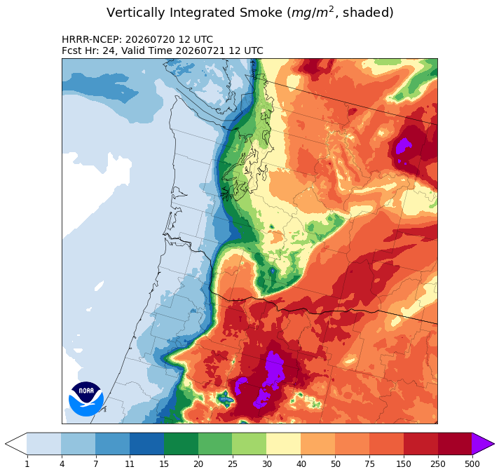
The return of ocean breezes Thursday into the weekend should bring us a reprieve from the smoke on the west side with temperatures getting back to usual summer comfort levels in the 70s by Friday and the weekend.
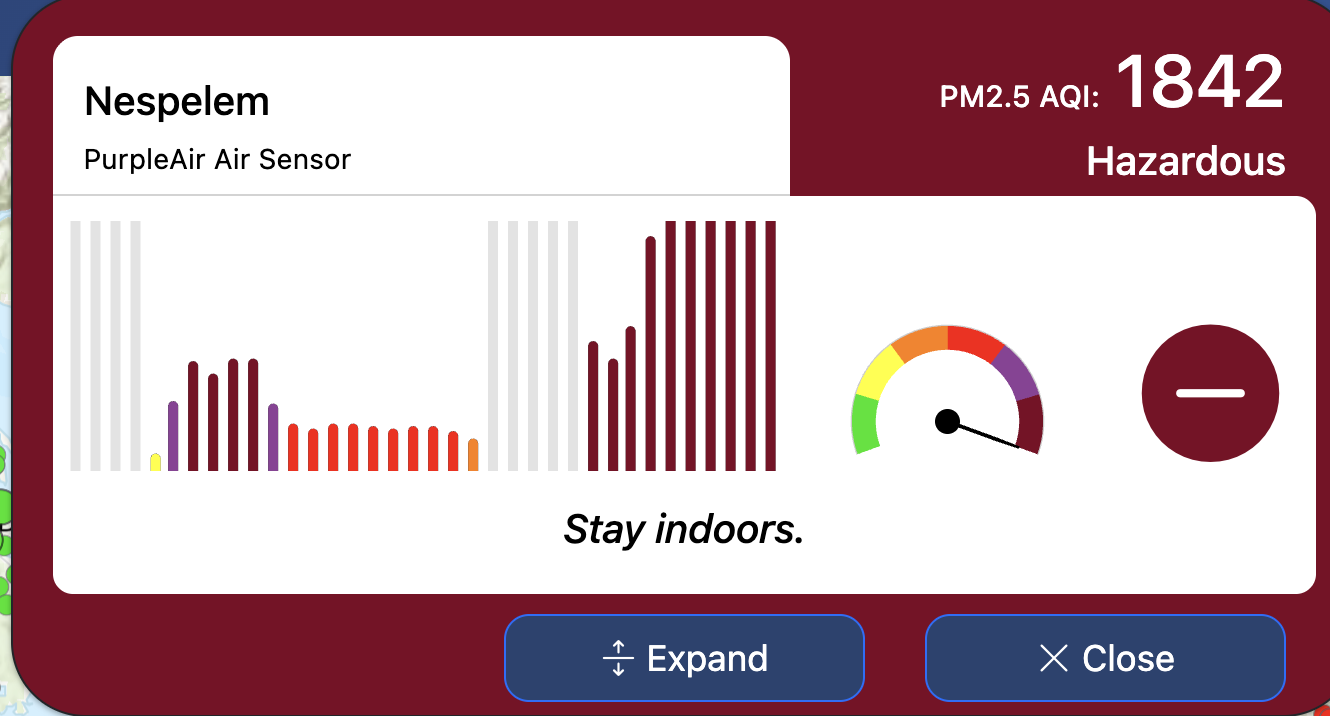
East side of the Cascades though it’s a mess. An air quality sensor in Nespelem near the wildfires reported an AQI of 1842 Monday morning. Anything over 500 is considered hazardous.
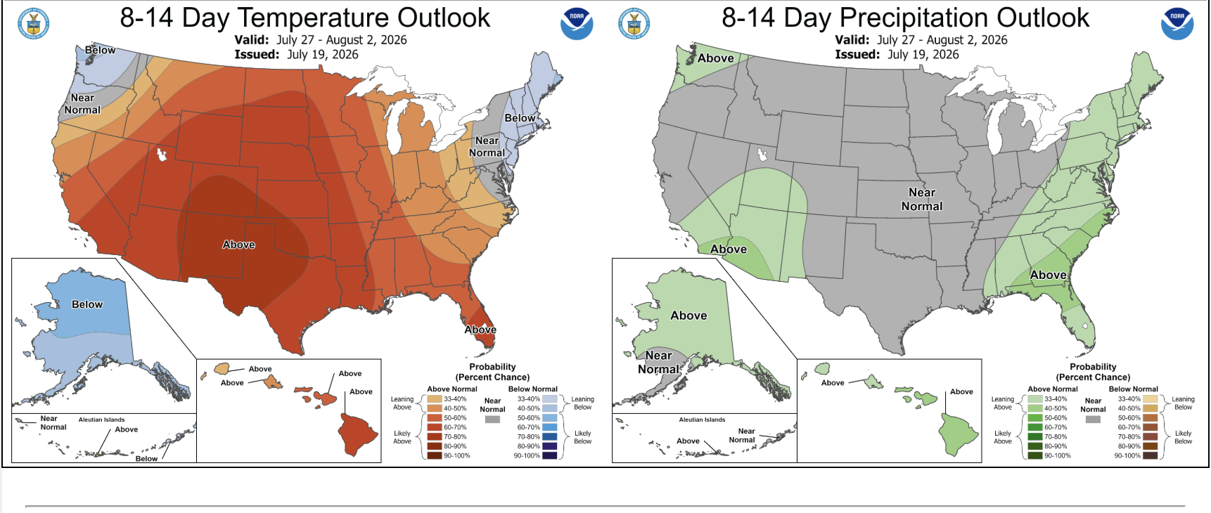
Long range models are showing some hope to finish July on the cooler and wetter side. Both the 6-10 day and 8-14 day outlooks from the National Weather Service have the Pacific Northwest under “cooler” and “wetter” than average.
(P.S. Surfers: Hurricane Fausto looks like it’ll pass safely well north of Hawaii in about 7-10 days but could get some decent waves on the north shores if the models hold.)