ECMWF 850 mb temp anomaly
(Non-math majors: “What?”)
(Math majors:….”Ummm, yeah Scott… What?”)
(CAUTION AHEAD: This post is rated “M” for… “Math”. Yes, this forecast uses obscure math vocabulary. If you were thinking you were coming to Facebook explicitly to avoid having to think about — or learn about — math, here is the TL;DWM (“Too Long; Don’t Wanna Math”) version: It’s going to get hot on Sunday and Monday, then it’s not. Thanks for stopping by!)
As you’ve probably heard, it’s going to get hot around Seattle. Yes, avoiding record heat is likely the preferable choice for a vast majority of people, especially in a region where air conditioning is about in similar abundance to Capitol Hill street parking.
BUT! If you were going to have to endure a heat wave, this is about the best version you can hope for, as there are a number of ways it could have been worse.
AND SOMEHOW YOU’RE GOING TO TELL ME USING ALGEBRA OR SOMETHING?
Maybe more like geometry.
First, the forecast: We’re already into the sunny phase, now it’s just the temperature climb. Highs on Friday will reach the low-mid 70s around Seattle, then reach close to 80 on Saturday.
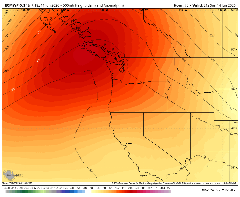
As a ridge of high pressure intensifies in the region over the weekend, we’ll start to bring in some warm, easterly winds that are the key to our local heat waves. The air undergoes a dual process of heating and drying as it blows over and then sinks down the western slopes of the Cascades, bringing a California/desert-like heat.
That heating engine starts to rev up on Sunday, with highs reaching the mid-upper 80s, and peaks on Monday with highs now pegged to reach the low 90s around Seattle; hotter toward the foothills and a little cooler along the coast.
91 DEGREES IN SEATTLE SEEMS PRETTY YUCK. HOW WAS THIS BETTER?
There’s what I count as at least five items in our favor with this heat wave that will help ease the impacts.
1- It’s a dry heat. With the easterly wind component, it won’t be humid at all, so your sweat will be more effective at keeping you cool (especially if, say, you’re playing soccer in front of billions of fans…)
2- While there will still be some fire danger with the hot and dry winds, it certainly helps that we had all that rain just a few days ago and have had occasional rain the past 6 weeks as opposed to a weeks-long bone dry streak leading into this heat.
3- It could have been hotter. The initial long range models were suggesting perhaps mid to even upper 90s were in the realm for the peak of the heat (some Euro ensemble models had 101-103!). We’ve already seen other heat waves around the planet in the first few months go well beyond the norm with the record-obliterating heat in the Desert Southwest at the end of March and the intense heat wave in Northern Europe a few weeks ago. We still have scars from June 2021 around here. But this will NOT be that kind of heat. (Though I do give kudos to the models for correctly sleuthing out a heat wave pattern for us 11-12 days in advance!)
4- There are places to escape the heat that aren’t far. It’ll still be warm on the coast on Sunday and near the shorelines, but more like upper 70s to low 80s.
And 5: It’s not going to last very long. Really, it’s just one day of the hottest heat. And then unlike stubborn Heat Domes that last for days, this ridge breaks down pretty quick and marine breezes start to cool us off as soon as Tuesday, increasing their cooling power through the week.
In fact, if you were to chart the high temperature forecast this week on a graph, it would look much like a parabolic curve (aaah! Math!)
What’s a parabolic curve? Essentially in this case, it’s an upside-down “U”.
The high temperatures gradually ramp up, peak, and then ramp down almost equally as fast.
The true math majors would look at the forecast and say it’s not *truly* parabolic — for that to happen the highs before the heat wave would have to equal the highs behind it. Right now we’re at 72-80-86-91-83-76-73. But since when do we have to be exact with math?
But more importantly, the forecast is mimicking a parabola, and not a flat ridge of days-long heat. The Monday Belgium-Egypt World Cup match will indeed be broiling. But by the time the USA match against Australia arrives next Friday, we should be back down in the 70s — perfect weather to turn that parabolic “frown” upside down 🙂