64 degrees in early February? Long range forecasts keep trying to pummel Seattle winter to oblivion
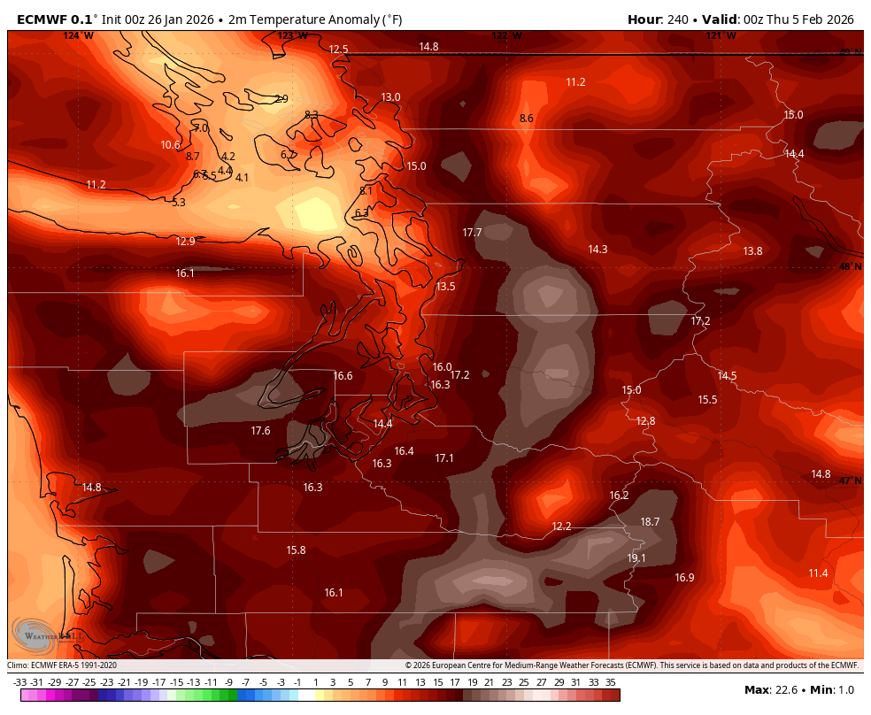
ECMWF High temperature anomaly map for Feb. 4, 2026.
64 degrees in early February? Really?
Winter weather fans, let’s hope the forecast models are engaging in some reverse psychology.
Coming off a two week dry stretch that had some winter chill at times, but definitely no winter precipitation, we snow fans have been desperately waiting for signs of when a lowland snow pattern would materialize.
There have been multiple occasions this winter when models in their 10-14+ day forecasts have hinted at Arctic air, and have even painted swaths of snow accumulations across the lowlands — Thanksgiving week comes to mind; and some in mid-December hinted at a possible white Christmas.

And then of course, as the days get closer, the Arctic air gets cold feet (bet that happens a lot) and moves harmlessly (for us) off to the east.
Then came: “Just wait till December….” “Maybe January will be better”…. “Well, February has been the winter savior the last several years when winter’s lagged at the start…”
And yet even now, when we have the mother of all Arctic air masses over North America…again, it shoves off to the East. Dallas and the Florida Panhandle are out winter-ing Seattle again for the second year in a row.
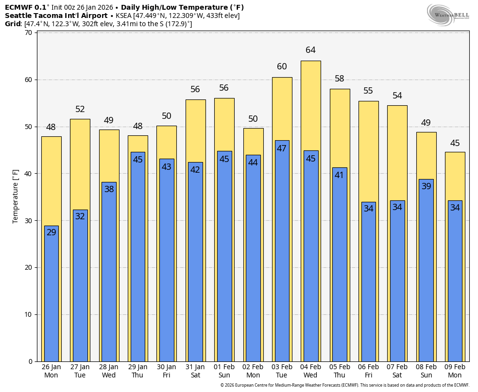
As mentioned in my previous forecast, the dry streak is coming to an end this week with even a return of an “atmospheric river”-type storm, albeit one that is weak to moderate strength and is not expected to cause any significant impacts. It just brings rain back in the forecast at times through the weekend, leaving January to end on a VERY WIMPY winter scale — heck, highs may reach the upper 50s on Saturday.

But then next week, the last few runs of the Euro model are showing a return of a very warm ridge of high pressure.
How warm?
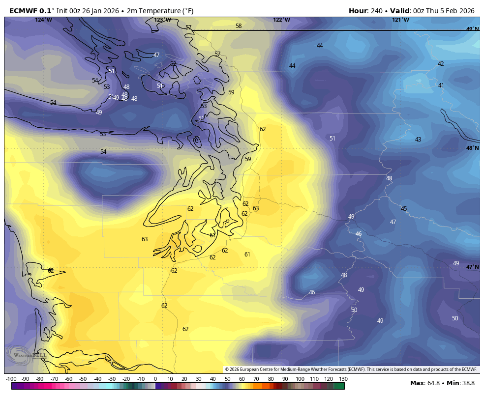
The Euro has pegged highs in Seattle of 62-64 degrees on next Wednesday. Wut? That would be right around the record highs for the date.
Now, normally I would be like “hey, don’t trumpet forecasts that far out, it’s just a few models runs; a lot can change, confidence is low, yadda yadda…”
All true.
But since it’s not like we’re predicting/hyping a hurricane or blizzard or significant winter storm or anything impactful or dangerous — just “dangerously pleasant” I guess — I’m making an exception, if only to say….
OK, long range models. You’ve teased us and teased us and teased again this winter on the cold air always at an arm’s length, never getting closer, leaving us mild instead. Perhaps this time, reverse the script and make it so it’s the mild air that instead gets switch back to cold air as it draws near?
Cascade snowpack is running only 40-60% of normal. A world-famous snowboarding contest at Mt. Baker just got canceled due to lack of snow. The first school semester is coming to an end and my kids have yet to use any snow days this year.
Can we get some more winter-like weather before winter is gone? Please?
-Signed: Snow fan in Seattle
iv been watching for 3 yrs about 20 differant times in a row high pressure ruins any chances for arctic air.. on the flip side mid west to the east coast have seen a brutal winter. what is really going on?