Why Seattle shouldn’t have to worry about this historic Polar Vortex event in the making
 Scott Sistek
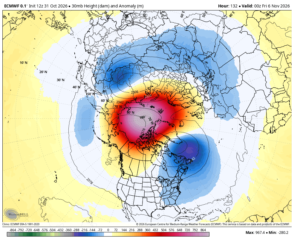
ECMWF 30 mb height anomaly for mid November
First it was “Super” El Niño. Then he got a sidekick: Kelvin Wave. Now it feels we’re staring an entire Meteorological Justice League with new media buzz terms “Sudden Stratospheric Warming” (SSW) and its “rime-might-ing” duo: the Polar Vortex!
OH NO! NOT NEW WEATHER BUZZ WORDS AGAIN! DO I HAVE TO WORRY ABOUT THESE EVENTS IN THE PACIFIC NORTHWEST?
Short answer: No.
(You can go “whew!” and stop reading here if you want… But if you’re a fan of the Price is Right, it’s worth your while to keep going.)
OK, I’LL BITE: WHAT IS ALL THE FUSS?
Let’s start with simply defining what these events are, beginning with the Polar Vortex. That is a wall of strong winds in the higher layers of the atmosphere (about 10-30 miles up) that circle both the North and South Pole, starting in the autumn as daylight fades and temperatures drop, and lasting through the winter. These winds act like a tall barrier, bottling up frigid arctic air around the poles. (“Polar” = around the poles. “Vortex” = circling wall of fast wind).
Think of the Polar Vortex like the outer walls of a castle, only in this sense, you’re keeping cold air inside the walls instead of preventing invaders in from the outside. The Polar Vortex will just spin up there for most — if not all — of the winter season keeping the coldest of the cold air stuck behind its “spinning” walls, sparing the populated lower latitudes from its frigid wrath.
But sometimes, big weather changes in the lower and mid-latitudes can propagate into the upper atmosphere of the polar regions and start messing with the Polar Vortex. One such effective way results in an SSW event where, as its name implies, the stratosphere (the layer of the atmosphere above where the weather happens) suddenly warms — sometimes 50 degrees or more.
While “yadda yadda”-ing most of the science involved, let’s just say that this sudden warming can begin slowing down its wall of wind, or in some stronger, extreme cases, even make the Polar Vortex reverse wind direction.
COLD AIR? COME ON DOWN!
This weakening of the Polar Vortex has the effect of dropping the castle walls.
What’s next? Now it’s a meteorological game of Plinko.
As that arctic air escapes its fortress and begins to sink south out of the polar regions, it’ll interact with the jet stream and weather patterns in the lower latitudes. Those interactions will dictate where the cold air goes – much like the chip bouncing its way down a Plinko board. (Only your prize isn’t $10,000+ in cash, it’s a $500+ heating bill?)
For the U.S., these arctic air masses tend to most frequently reach the eastern half of the continent (think of them as more the center area of the “Plinko board”), which is why you’ll see a WHOLE lot of national media attention (like now) during these events because more often than not, the cold air is heading for the larger populated areas of our Midwest and East Coast.
Typical scenarios would be that somewhere in the Great Lakes/Upper Midwest or Northeast/mid-Atlantic would expect a bout of cold weather some 2-4 weeks after the event begins. So everyone’s eyes get peeled to watch the models for signs of an arctic intrusion. (Spoiler Alert: Probably not this time though….)
But while these polar vortex-wobble arctic intrusions aren’t unheard of for the West Coast, they are much more infrequent, and thus why “polar vortex” and “SSW”s don’t get as much attention out here.
YEAH, BUT THIS EVENT SEEMS EXTRA-HYPEY?
Indeed, because much like the hot ocean temperatures and “Super” El Niño are doing something we’ve never seen before, this SSW is also doing something we’ve never seen before: Making an appearance in early November. (And yes, we think they’re related.)
Usually if an SSW event is going to happen (and it doesn’t happen every winter, though they have become more frequent in recent years) they’ve all occurred in the heart of winter when the poles are at their darkest and coldest. The earliest an SSW event has been observed is currently November 28.
But meteorologists have been staring in utter disbelief at the recent forecast models indicating an SSW is imminent in early November — right now, pegged for between Nov. 4-10. Find any news article on this, and you’ll find a quote from some researcher expressing some magnitude of shock.
But the models’ confidence has only increased with time, to where now it’s getting close to near 100% certain it’s going to happen.
SO YOU’RE SURE I DON’T NEED TO WORRY ABOUT THIS IN THE NORTHWEST?
Correct. This is likely a nothing-burger for Seattle and the Pacific Northwest. And it may not mean anything for the East either.
Instead, using past SSW events as a timing guide, East Coast meteorologists would then start looking around Thanksgiving time for some sort of arctic blast somewhere in the eastern half of the U.S.
Great timing, eh?!? Not like anyone has to fly through Chicago or New York or D.C. around that time, right?
BUT there’s another very important wrinkle with the event coming so early: It’s just not that cold up there yet (relatively speaking). Northern Canada is totally not-arctic right now. So while air may “spill” from the north, it may not be all that cold, or at least just “cool” not “cold.”
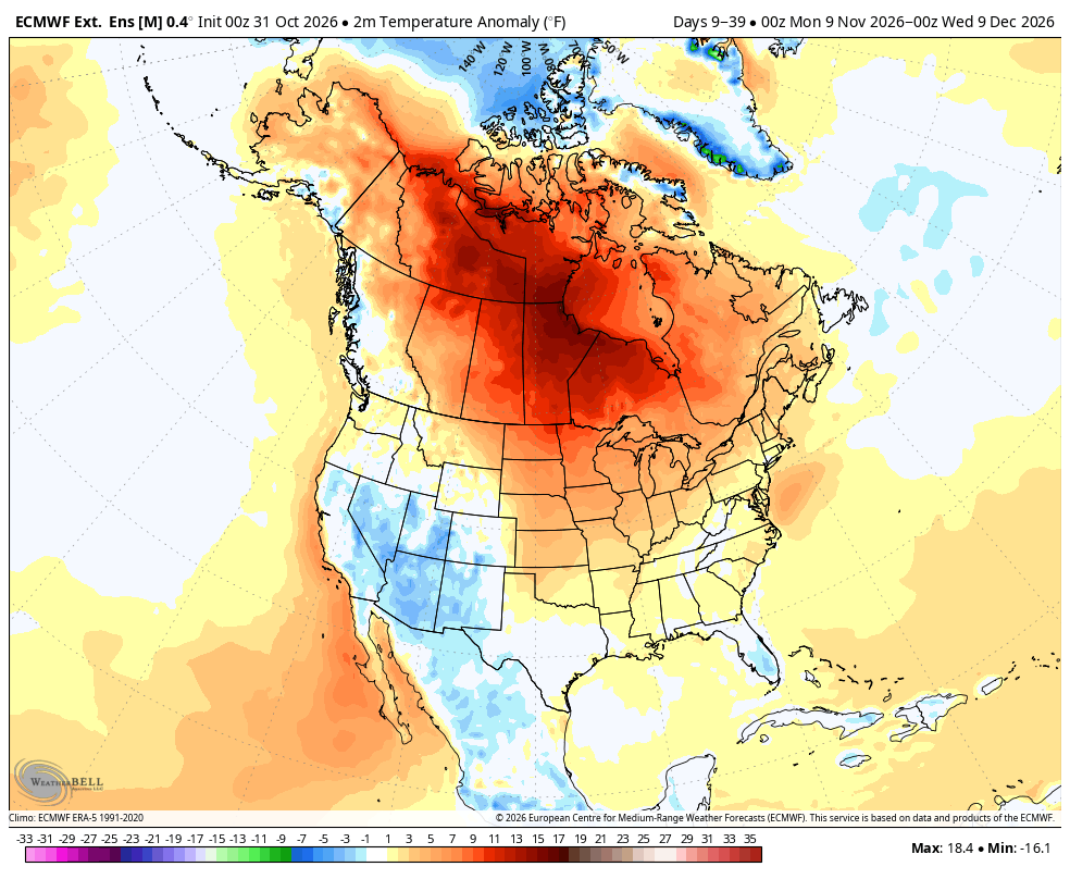
Plus, Super El Niño and its super warming powers are still a thing and it’ll be fighting that influence as well. For what it’s worth, the actual longer range models are still depicting widespread above-average warmth across northern Canada in November. So despite the historically early arrival, there may not be any impactful cold air to go with a SSW event this early.
Suffice to say, we’re not sure how this will all play out as it’s a whole lot of “unprecedented” events mixing together. What does look reasonably confident to say is that we in the Northwest will be on the sidelines.
NOT SNOWY, BUT… WINDY?
But that’s not to say our weather won’t be active. While Thanksgiving is too far out to get any kind of feel on a forecast, the weather pattern is starting to look more active as we get past next weekend — right on time for mid November.
So don’t worry too much about snow around here with the SSW event. To go back to The Price is Right analogy, if anyone starts bidding on lowland snowfall totals in the Northwest for the end of November, I’d go with $1.
LET’S RECAP WEATHER BUZZ WORDS THAT MATTER TO THE NORTHWEST:


MORE TO EXPLORE:
- Las Vegas rallies to beat Seattle in October rainfall with just minutes to spare
- What is a Kelvin wave? Why Seattle shouldn’t need to worry much about El Niño’s sidekick
- Here’s the ‘script’ Super El Niño’s have used for past Seattle winters. Now, toss it out.