The legacy of Seattle’s ‘Rule of 9’ when it comes to forecasting 80 degree heat
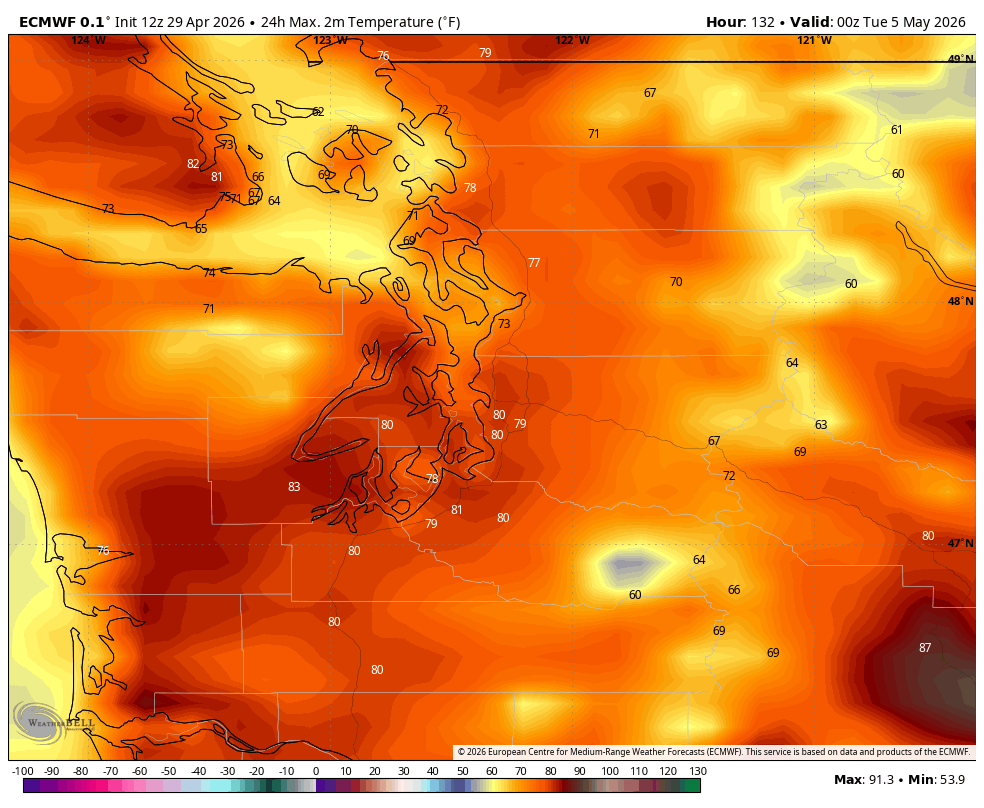
ECMWF forecast model showing (finally) highs of 80 degrees in Seattle on Monday.
Sunday and perhaps even Monday are looming as the warmest days of the year so far in Seattle. But will it hit 80? Many forecasts I’ve seen are going just shy at 79.
But is it *really* a forecast of 79? Or just a psychological hedge?
This brings back fond memories of working all those years with KOMO’s legendary weathercaster Steve Pool. Early in my career there as his weather producer I learned the ways of the “Rule of 9”. When you’re coming into spring and/or early summer and you are on the edge of that first 70 or 80 degree day of the year, best to keep expectations lower and go with ’69’ or ’79’ instead of the more psychological barrier of 70 or 80 — ESPECIALLY the “80.”
We even wrote about it our 2005 book (which for some reason is $198 on Amazon?!?! It was $14.95) — on page 6.
“Those numbers with a ‘0’ on the end seem to have magical powers on a weather forecast,” Steve wrote. “Think about it: Sunny and 70 sounds a whole lot nicer than Sunny and 69.”
In that sense, we’d use it as a way of managing expectations — if we forecast 70, or 80, but it only gets to 69 or 79, we’d hear about “the big forecast miss.” But forecast 69 or 79 and it hits the big 7-0 (or 8-0) and it’s “bonus warmth.”
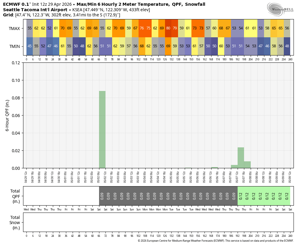
I’ve been watching as the official NWS forecast for Seattle has been hovering right at 79 for Sunday or Monday for a few days now. They have yet to pull the 80. Looking at the local media sites right now: KOMO, KING, KIRO and KCPQ? All going 78 or 79.
Somewhere, Steve is grinning.
Me? Don’t tell anyone but I think we’ll hit 80 at Sea-Tac on Sunday and maybe even Monday though that day is a wildcard with the marine winds in flux.
No 80s yet though. We’re still in the Goldilocks Zone for temps. We’ll see highs in the low 70s around Seattle Thursday then a slight cool down Friday as a weak front reenergizes the marine layer for a day and we end up mostly cloudy.
But high pressure begins to reestablish over the weekend, leading to highs back into the low 70s on Saturday.
It’s Sunday and Monday(ish) where we get the peak of the heating now, with sunny skies as the ridge moves close to overhead. The record highs are well into the mid-upper 80s this time of year and while this is not a record-heat pattern, that does suggest we’ve got wiggle room with a building ridge overhead to at least punch 80 on at least one of the days, especially if we can get a little offshore wind. The latest Euro model agrees and now has 80 for Seattle’s Monday high at least.
HOW RARE IS 80 DEGREES THIS EARLY?
Not ultra rare.
Seattle’s average first 80 degree day is around May 16-20. Last year we had to wait until May 28, the year before was May 10 and then April 28 in 2023. So reasonably in line with Seattle climate if we do get there, which we probably will .
Good news for those who would rather flirt with the 69/70 barrier for temps, this “heat wave” won’t last long, with Monday being a transition day back to cooler, onshore flow. There is still some uncertainty in the timing to where Monday could end up 80 ish before the marine winds arrive or if we cool off sooner, but by Tuesday we’re back to more “usual” May temperatures.
Next time it’s relevant: The psychology behind “partly sunny and mostly cloudy” (That’s on Page 7…)