Atmospheric river may bring some slushy snow to Seattle and Puget Sound region Friday
HRRR 3-hour snowfall map for Friday early morning. (NOTE: These calculations do not factor in warm ground temps that would melt much of this snow on impact but gives an idea where snowfall may be the heaviest)
So, about that Friday the 13th…
To say this week’s weather has been wacky is to sell “wacky” short. Now after all the rain and wind and even a few isolated flashes of lightning this week, the storm may now pull the lowland snow card from its apparent deck of chaos.
OOOH! OOOH! OOOH! SO YOU’RE SAYING WE ARE *FINALLY* ALLOWED GET TO GET OUR HOPES UP!!!!!
Well…. maybe a *little* but not too much! As lowland snow goes, this is still probably going to be very disappointing. But I feel snow fans are to the stage of even on a scale of 0-10 and this might rate a ‘1’ or a ‘2’ — it’s better than the 0.001s we’ve been dealing with all winter.
(Skipping ahead for the “Too Long; Don’t Wanna Read So Give It To Me In One Sentence” folks: We may see some wet snow between the pre-dawn hours Friday until about mid morning — yes, including the Friday morning commute — with slushy accumulations on grassy surfaces and maybe a couple inches in the higher elevations above 300-500 feet that could pose brief travel challenges during the snowfall but will quickly melt once the snow stops and the day warms.*)
(*You didn’t say it couldn’t be a run-on sentence…)
WHAT IF I AM ONE OF THE “IDCHL;WR” (‘I DON’T CARE HOW LONG; WANNA READ’) FOLKS?
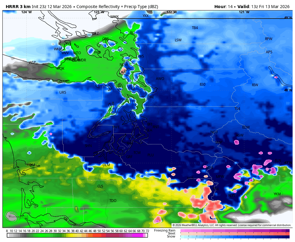
Much like our prior wimpy snow chances, this one is predicated on fringey freezing temps and moisture trying to find us at the same time. This time, the moisture is here. That band of persistent rain (technically a weak atmospheric river) that has been soaking Northern Oregon and southwestern Washington for two days has moved back north into Western Washington and it looks like it’s going to hang around through the night and into Friday morning.
Thursday afternoon temps were in the 40s, and for the evening and most of Thursday night, we’re going to still be too warm for snow, just more of the same rain.
But two things start to chalk up some points for mixing in to snow or even turning to wet snow: Temperatures will cool overnight into the low-mid 30s, and precipitation intensity may increase a bit.
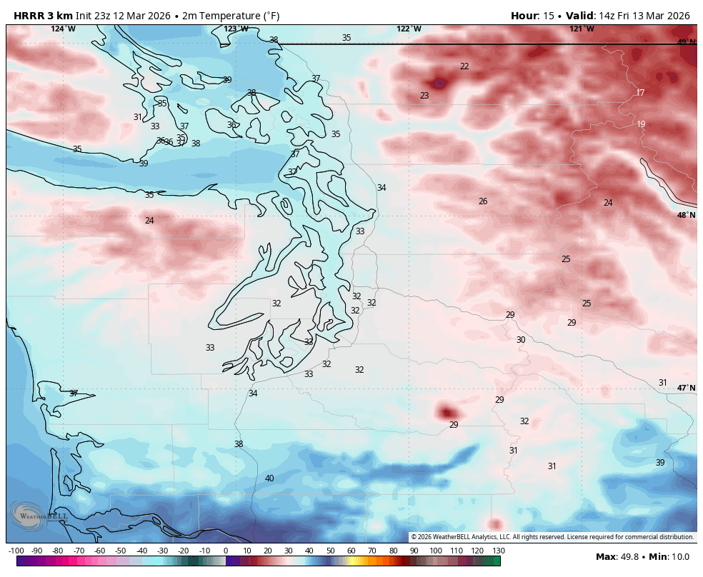
It doesn’t look like we’re going to get to solid freezing — more like generally low-mid 30s for lows so snow levels will likely not quite make it to sea level; instead maybe to around 300-500 feet or so. That means wet snow or rain/snow mix In general around Seattle Metro, unless you live in higher elevations in the outlying areas, in which case you may see some slushy wet snow for a while.
But the high resolution models are picking up on a core area where the “rain” will be heavier between about Seattle and Olympia — so essentially the Central and South Sound — where the increased intensity in the precipitation can push down snow levels to the surface.
This is an area where I could see a temporary few inches of snow during the event, which yes, includes the entirety of the Friday morning commute.
HOWEVER, for the drivers (as in of cars, not golf clubs) don’t forget we haven’t been freezing at all lately, so the roads are warm — The City of Seattle’s “SnowWatch” page shows road temps around Seattle Thursday evening were 46-48 degrees. It’s going to be hard for this stuff to stick, especially the well-traveled roads.
The ONLY way this is going to work is if it snows so hard that it accumulates faster than it can melt — possible, but temporary.
So a scenario that I could see as plausible is it’s snowing outside – WOO! YAY! SNOW! – but it’s not really sticking to much of anything for a while, then maybe you start to get some accumulations on the grassy surfaces and stuff, but the roads I think in general will be OK, especially like the I-5s and I-90s and I-405s and 167s of the world. However, the snow could make for low/foggy visibility and even slush is slippery so no driving like Mario Andretti out there, or Mario Kart.
Those of you in the North Sound aren’t out of the mix either — you have the bonus that it’ll be cooler up there being on the northern side of the precipitation, just you aren’t expected to be quite as wet. So the snow may be lighter, but a little better chance of it being snow/slush than rain.
Of course, the higher you are in elevation, the better chance you’ll have of seeing snow with slushy accumulations.
I SAW SNOW MODEL MAPS ON SOCIAL MEDIA HYPE FEED THAT ARE SHOWING 3-4 INCHES OR MORE? AND… IT GOT MY HOPES UP MORE (SORRY!)
Remember those models calculate how much snowfall potential is there by atmospheric conditions, not ground conditions. The model might think there’s 2-3 inches worth of snow falling, but it’s melting on impact, it won’t actually measure 2-3 inches where it counts.
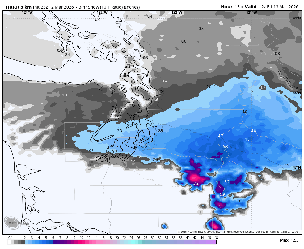
So in these fringey temperature situations, snow model maps will overestimate snowfall totals.
HOW LONG WILL ANY SNOW STICK AROUND?
Not long. This snow is only on the board during the coldest part of the night and early morning. Friday’s high temperatures are still expected to reach the low 40s, so whatever slush manages to survive the morning won’t survive lunch or afternoon coffee.
In that sense I don’t suspect we’ll have any school closures tomorrow in near sea-level districts, but maybe a few 1-2 hour delays? We’ll all be safely back to rain by midday if not sooner… except in the mountains and passes where Winter Storm Warnings last into Saturday and more gobs of snow keep falling.
(Btw, we are in a similar fringey temp situation again Saturday morning where this wet, slushy snow could fall, but much less moisture around then, so it’ll be way more isolated and sporadic.)
COLD WEATHER FANS, REMEMBER THIS CHILLY FEELING
There is still SO much to talk about in the long range forecast — renewed atmospheric river shenanigans, temperatures maybe near or crossing 60 degrees next week, a bonkers/historic heat wave that will bake much of the rest of the West that at least by atmospheric anomaly measurements could rival our June 2021 heat wave, and the potential return of not only El Niño but Super/Godzilla El Niño for next winter. Gross!
I’ll expand more on those items this weekend once we’re past the snow threat. I think I’m already even pushing the limits of the IDCHL;WR folks 😉
MORE TO EXPLORE:
- 134 mph gust reported atop Alpental Summit while Seattle gets its strongest gust in months
- It has finally snowed in Seattle this year… for 34 minutes (so far)
- Flip those PJ’s inside out? Some ideas to bring winter weather back to Seattle