Windstorm looms for Western Washington lowlands with blizzard conditions in Cascades
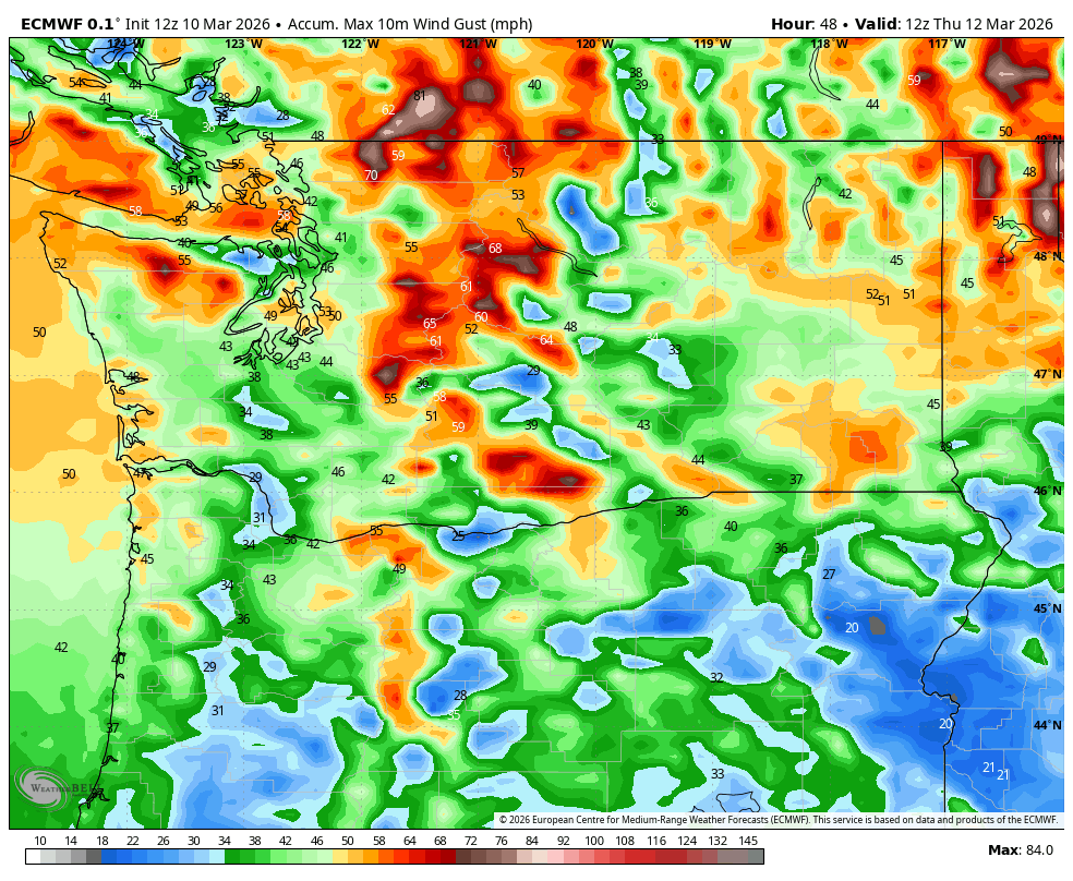
ECMWF predicted peak wind gusts for Wednesday
It’s been a while since a good storm has pushed through Western Washington, but that wait ends tomorrow.
A potent low pressure center is looking a bit stronger for when it sweeps through the region Wednesday and that means the windspeed forecasts have bumped up and wind alerts have been issued.
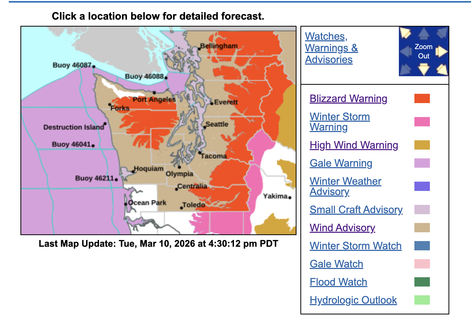
For the mountains, blizzard conditions are still likely for much of Wednesday but a very complex forecast of bouncing snow levels amid the heavy precipitation and fierce winds.
Let’s break it down.
LOWLAND SNOW: GONE
Such as it was, our lowland snow chances are now done. Thanks for playing the Western Washington snow lottery. Sorry you lost. (At least you didn’t get your hopes up, right? 😉 )
WEDNESDAY: STRONG WINDS, HEAVY RAIN, MOUNTAIN BLIZZARDS
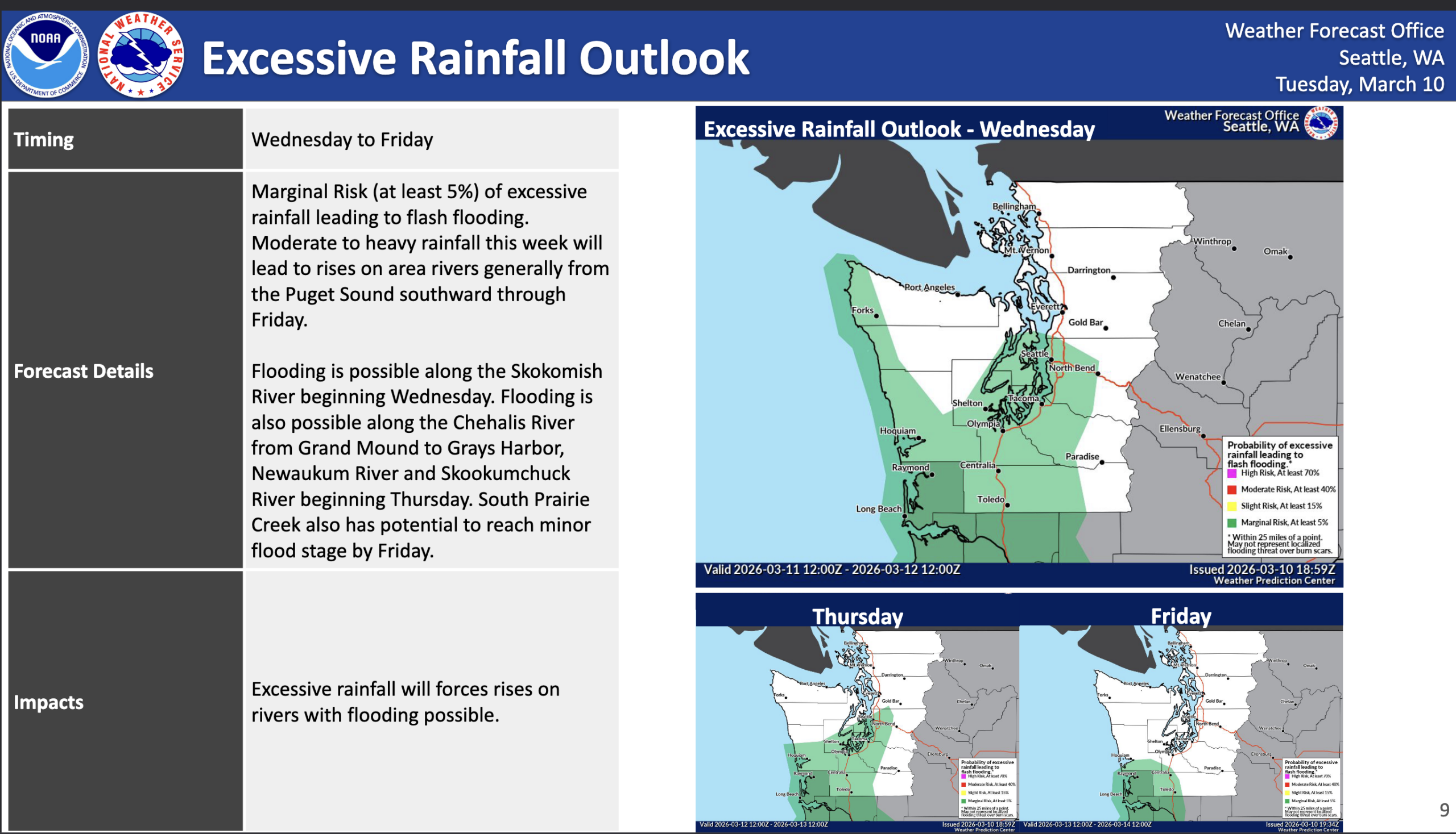
The storm starts its heavy rains in the pre-dawn hours Wednesday and for much of the day it’ll be steady moderate-to-heavy rains in the lowlands and heavy snows in the Cascades and Olympics, including the passes, as the strong westerly jet stream slams copious amounts of moisture into the mountainsides.

That westerly flow will create some rain shadowing across the North Sound so the rain will be less intense there, but will remain heavy from Seattle south and closer to the Canadian border. It may be warm enough in Southwestern Washington and northern Oregon that more rain than snow falls in the mountains and some rivers may eventually flirt with flood stage.
The low pressure center is expected to move onto Vancouver Island in the mid-afternoon and sweep across the region into inland B.C. by late evening or just after dark.
For the lowlands, this will pick up the southerly winds in the afternoon and evening with peak winds about 3-8 p.m. with perhaps a surge of really gusty winds as the storms strong front pushes through around dinner time.
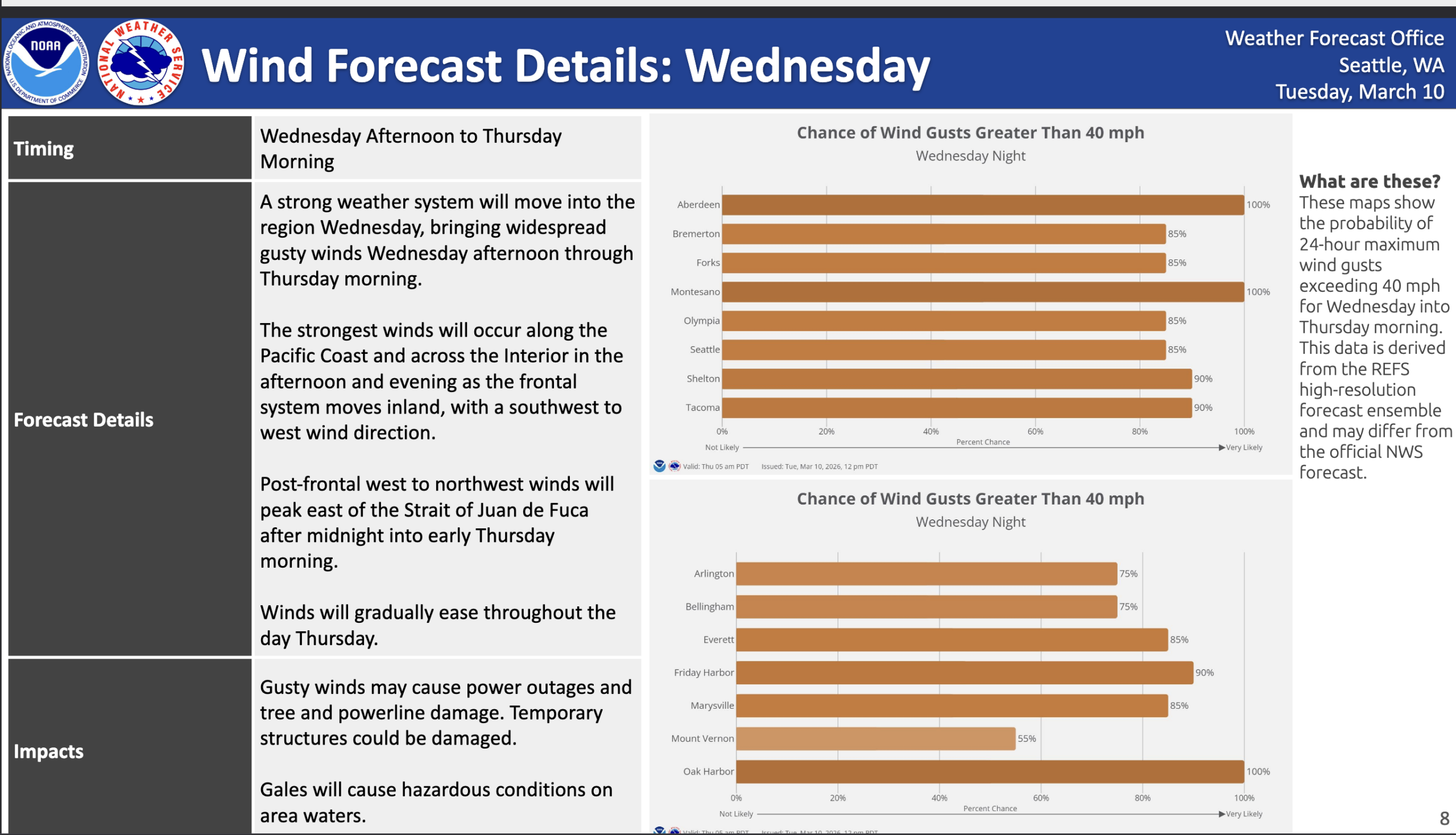
Wind Advisories are in effect for much of the Western Washington lowlands, including the greater Seattle/Puget Sound metro area, for gusts of 45-55 mph. Trees are just starting to get a little leafy in spots (at least the cherry blossoms are starting) so that could make us bit more susceptible to power outages.
WRINKLE ALERT: (No, not my laundry): High resolution forecast models are showing a westerly surge of 45-55 mph winds chasing this very strong front down the Strait of Juan de Fuca, and into Whidbey, Camano and San Juan Islands, and then into the Everett and Snohomish County areas from about 8-11 p.m.. These westerly wind surges are usually more dicey for power outages because the trees and such aren’t used to strong winds from that direction.
So while everyone should at least be on guard for possible power outages Wednesday evening, the North Sound faces this double whammy risk.
(Also High Wind Warnings for Eastern Washington too! Gusts 55-65 mph in places)
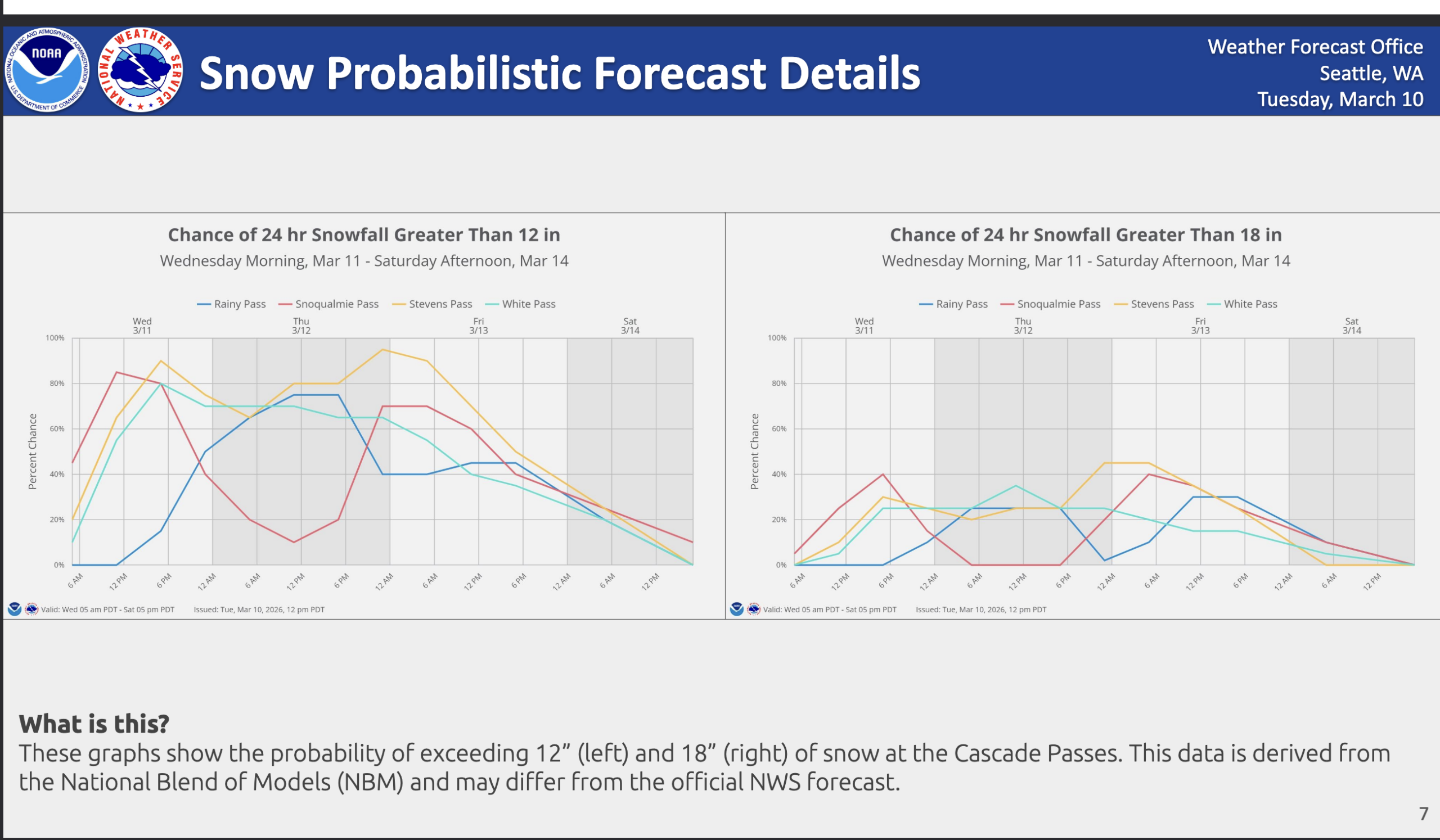
MOUNTAIN CHAOS FOR WEDNESDAY
The Cascades and Olympics will be plastered with heavy snow through much of the day, but things get even more complex when that low starts to move through.
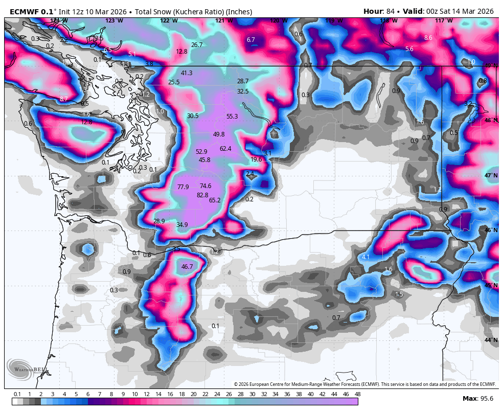
It will bring a warm front through first Wednesday afternoon that will send a punch of warm air into the region, briefly spiking snow levels up to around 5,000 feet and perhaps turning what was heavy, blowing snow in the passes to a heavy, wind driven rain (especially Snoqualmie Pass). Snow levels will crash down back below pass level once that cold front passes in the evening, turning it back to heavy snow.
Thus the passes day Wednesday will be like: Heavy snow, Heavy snow, snow snow snow + wind, LOTS OF SNOW AND WIND, “AUNTY ‘EM, IT’S A BLIZZARD!”, LOTS OF…. RAIN? AND WIND, OH LOOK IT’S BACK TO LOTS OF SNOW AND WIND and then… snow snow snow snow from there.
Suffice to say unless you really feel like you want to chance I-90 in that rain gap which will still be miserable with lots of blinding rain on top of recent snow with 45-50+ mph wind, it’s a day to skip. There could be avalanche issues too.
The weather in the lowlands calms down Thursday morning as the front passes and we just stay in frequent scattered showers into Friday (with likely convergence zones again.)
However, with the cooler air back and the jet stream still slamming into the mountains, heavy snow will continue at times. The Blizzard Warning will change back to a Winter Storm Watch starting late Wednesday night and lasting through Friday and the NWS has pegged nearly 4 feet of new snow just in that time frame on top of the several inches of snow already fallen this week.
The weekend will be relatively lull compared to this week, though the door is still open for scattered showers at times — maybe mixing with a few snowflakes again Saturday morning (HEY! NO NO NO! STILL NO GETTING HOPES UP).
We may eke out a dry-ish period Saturday afternoon Into early Sunday before rains arrive later in the day.
WHAT’S NEXT? LEMME GUESS: NOT SUNNY AND 63?
Ummmm, correct.
We’re still watching long range models pick up on a potential warm, atmospheric river event for early to middle of next week that would bring heavy rains to both the lowlands and the mountains and could trigger some flooding worries.
Still too early to hone in on it, but the overall weather pattern remains active through at least next week. But as mentioned yesterday, if you need some sun and early summer heat, it’s not too far away. California and the Desert Southwest will very hot this weekend into next week.